
Listen
| Listen / Luž | ||
|---|---|---|
 Listen from the north |
||
| height | 792.6 m above sea level NHN | |
| location | Saxony ( Germany ) / Czech Republic border | |
| Mountains | Zittau / Lusatian Mountains | |
| Dominance | 25.8 km → Černá hora ( 811 m , Jeschken Mountains , northern neighbor of the Jeschken ) | |
| Notch height | 368 m ↓ E 442 northeast of Jítrava | |
| Coordinates | 50 ° 50 '56 " N , 14 ° 38' 49" E | |
|
||
| Type | Kegelberg | |
| rock | descending phonolite , tephrite , slag tuff and sandstone | |
| Age of the rock | Tertiary and Upper Cretaceous | |
| particularities | Highest mountain in the Zittau / Lusatian Mountains Viewing platform |
|

The Lausche ( Luž in Czech , Łysa in Upper Sorbian ) is at 792.6 m the highest mountain in the Zittau Mountains and in the entire Lusatian Mountains as well as the highest elevation in Germany east of the Elbe .
Location and surroundings
The Lausche rises above the village of Waltersdorf on the north and the small settlement Myslivny (Jägerdörfel) on the south. The state border between Germany and the Czech Republic runs directly over the ridge . The Wache / Stráž pass is located 700 meters east of the summit . At the northern foot, in the Eisgasse through which the Kohlflössel flows, lies the Neue Sorge settlement with the Sorgeteich. The Finkenkoppe rises to the west and the Weberberg to the northwest .
history
Because of its conspicuous shape, the mountain was still called Spitzer Stein in the Waltersdorfer church book in 1538 , and Spitzberg was also in use. It was not until 1631 that the current name Lausche appeared and replaced the previous name until the 19th century. The name was derived either from the old Czech louče for divorce, separation, border or from luschen , which means “to lie in wait for game”, “to lie in secret”. Until the 20th century, the inhabitants of Waltersdorf, saying Großschönau from noon Barg , with lunch as a synonym for the South is to be understood.
From the 16th to the 20th century, a significant amount of sandstone was mined on the northern slope . Names like Wändebruchstiege and Steinbruchweg remind of it to this day. The natural stone was used for B. as a door frame or for stonemasonry and sculpture work . In 1719 Johann Benedict Carpzov reported in his book New Temple of Honor of Merckworthy Antiques of the Marggraffthum Ober-Lausitz of several ore mining attempts on the Lausche and the neighboring Butterberg . They should be traced back to the year 1538, was won u. a. Silver ore .
The touristic development of the mountain is closely connected with Carl Friedrich Mathes. Before there was only one steep path on the eastern slope, the Waltersdorfer shopkeeper and shoemaker laid out another hiking trail to and a rest area on the summit in 1805. Allegedly a dream inspired him to build the serpentine Lausitzer Weg and the Lausche- Baude , initially a simple wooden house, in 1823 . A pavilion was added until the license was granted on July 31, 1824 . The Lauscheborn , which was set in stone in 1823 , was a source in the central north slope for the water supply . The 120 meters in altitude were overcome by donkeys . In 2005 the edging of the Born was renewed.
With advertisements in the Priviligierte Zittauische Nachrichten , Mathes addressed nature lovers who enjoyed hiking, especially praising the view, sunsets and sunrises. The advertising led to a surge in the number of visitors. In 1825 he built a bowling alley and in 1830 a dance floor. Contemporaries reported Harfnerinnen , barrel organ players and dances for violin . From May 1831 Ignaz Krische sold glassware as souvenirs, on May 15, 1881 the Steinschönauer celebrated his 50th anniversary at the summit. The view from the small viewing platform added in 1833 has often been equated with that from the Schneekoppe .
Around the middle of the 19th century, members of the Free Church gave sermons on the Mount on the Lausche. In 1851 Ferdinand the Benevolent stayed in Zákupy Castle (Imperial City ) and went on excursions in the area. Especially for the Austrian emperor, the Bohemian Way was serpentine over the southern slope. Since this access was more convenient than the northern one, it was not only chosen later by Friedrich August II , King of Saxony, the donkey teams also fetched the water for the hut from the listening fountain .
After several renovations and new buildings by the descendants of Carl Friedrich Mathes, the guests of the Lausche-Baude could choose between the Saxon guest room and the Bohemian parlor. The names were not chosen by chance, because the state border between the Kingdom of Saxony and the Empire of Austria ran right through the hallway . Payment was made in both common currencies.
As part of the royal Saxon triangulation , Lausche was station 5 of the first-order network (Central European degree measurement). After the building permit was granted on May 8, 1863, the Saxon measurement commissioner Christian August Nagel erected one of the pillars that were later named after him in October 1863. The building site was on Bohemian-Austrian territory (today Česká republika ), the construction costs amounted to 826 marks. The Saxon surveying pillar was demolished in 1941, and there was also a second, Bohemian pillar at times. In 1936 and 1962, astronomical observations were made at the summit .
The increasing number of visitors made the old mountain restaurant too small. Thanks to the efforts of several Saxon associations, a new, larger Lausche-Baude was built in 1892, divided into a German and an Austrian part. In the former was Zittau , in the second Zwickau Czech- served beer. The guest rooms were comfortably furnished with tiled stoves , wooden walls and stuffed birds. At the same time, a ten-meter-high wooden observation tower was built right in the middle of the building and the current version of the Lausitzer Weg on the north side.
Even before 1900, the Waltersdorf children were tobogganing with their Kasehitschen ( Upper Lusatian word for a simple, wooden children's sledge ) down the steep northern slope, this is considered to be the beginning of the local winter sports area . In 1898, the host-initiated listening for models from the Giant Mountains a horns carriage race . Since the 1930s, skiers have dominated the slopes , especially on Sundays . In 1969 three alpine ski slopes were laid out, the western one for slalom , the middle one for giant slalom and the eastern one below the Hubertusbaude for downhill skiing , the latter two with a lift .
The Lausche ski jump , built in 1923 or 1928, enabled widths of 50 meters after modifications in 1955/56. The upper part of the landing was made of a wooden structure. In 1972 the sports facility was demolished because it was in disrepair. The wooden referee tower, which is today used as the ski home of the Alpinen Skivereins Lausche e. V. serves.
After the Second World War (1939-1945) barbed wire fences blocked the state border. The stream of tourists to the summit and to the mountain inn, then owner Alma Goldberg, dried up. On January 8, 1946, many people from Waltersdorf attended a country film screening . When the film roles were changed around 6 p.m., the terrible news quickly got around - the Lausche-Baude is on fire. After the fire, which was visible from afar, only the foundation walls that can still be seen today remained. The cause of the accident could and should never be clarified; arson was suspected. Reconstruction plans had existed since the 1960s but were never implemented. 1967, received at the northern middle and upper slope remained were the rest of the montane mixed forest of 11.7 hectares large nature reserve Lausche explained. After the border fortifications were removed in the 1970s, the summit was again accessible from both sides.
After many years of planning, a viewing platform was built on the Lauschegipfel around the existing transmission mast between 2018 and 2020. In this context, the summit plateau could also be redesigned. The viewing platform was released on August 21, 2020, the day of Upper Lusatia . The concrete required for construction and the components were transported to the summit by helicopter.

Listen in winter

The mountain from Bohemia

Listen as seen from Plešivec

The Lausche summit plateau in 2011
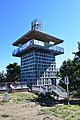
Viewing platform


.jpg)


The legend of the miracle bird on the Listen
A legend about the Lausche goes like this: Only very rarely can a bird of strange shape be observed on the Lausche. Its head and beak seem to come from a lammergeyer , the large wings from the frigate bird , the tail from the secretary and the stand from the stork . The beautiful plumage is unique in color. This strange-looking animal is nothing more than a prince from the Bohemian region who has been cursed with an evil curse. Because of his beautiful face and charming figure, his skill in all the arts and sciences of his time, his philanthropic and benevolent nature, the youth was considered the perfect model of a prince. There was only one vice stuck to him; he was a little too eager to hunt.
It happened during a foray into the foothills of the Lausche. At noon a majestic eagle circled the mountain. Sent from the prince's bow, an arrow, flying further than ever before, hit the king of the air and he fell from the sky to the ground. The unfortunate coincidence would have it that he fell into a garden of a magician, which was then on the Lausche. The man, well versed in the black arts, was startled from his afternoon nap by the noise it caused and was furious about the damage to the bushes and flowers. When he noticed the archer with his bow, the magician took up his wand, touched it with it and said the words: “Be one of the sex of which you have killed one, until you are a hunter who has never embezzled his rule , killed! ”The prince is waiting to this day for his redemption.
geology
The Lausche deposits marine sandstone series of the Upper Cretaceous , which can be assigned to the northeastern edge of the Bohemian Chalk Basin. Outcrops are located in the former quarries about 750 m north to northwest of the summit (Helleberg, Mittel and Wändesteinbruch). At the foot of the Lausche, the sandstone can be identified from a few reading stones up to approx. 710 m above sea level, but there is no evidence. It can be assumed that the sandstones found at this altitude belong to the upper Unterconiac (approx. 89 million years).
The Cenozoic development on the Lausche, explained below, is based on the findings of a geological detailed mapping and the volcanological reconstruction of the mountain based on it, which was published in 2017:
The remnants of a terrestrial granite rubble fan have been preserved at the Lausche. The rubble fan comes from the granitoid basement of the Lausitz, which only comes to light about 1.25 km north of the Lausche. As a result of extensive tectonic uplift of the Lusatian basement along the Lusatian thrust , the granite was removed and poured into the sandstone area immediately to the south at the beginning of the Tertiary. As a result of the covering of the relictic rubble fan by lavas, which erupted in the Lower Oligocene, it has been preserved from complete erosion to this day. Similar deposits are known from the Sonneberg approx. 1.5 km east of the Lausche.
The Lausche mountain cone is the remainder of two volcanoes that erupted close together in the Lower Oligocene, but at different times. The volcanic activity started through phreatomagmatic eruptions . Here, rising magma came into contact with groundwater, which led to multiple thermohydraulic explosions underground, which fragmented the magma and the surrounding rock like shock waves. Thus, an initial maar diatreme volcano was created at the Lausche, which is a collapse funnel in the underground ( diatreme ) that tapers towards the explosion point and which widens in the uppermost part to a crater ( maar ). As the groundwater supply gradually came to a standstill, the subsequent magma reached the surface of the earth. Strombolian eruptions followed about 31 million years ago , caused by the release of gas from the rising melt. Foamed scraps of lava - so-called slag - were thrown out and a slag cone formed at the Lausche . As the gas content of the melt decreased, the strombolian activities came to a standstill and there was a direct transition to the "silent" (non-explosive) lava effusion, whereby the crater of the cinder cone was filled with a tephritic lava lake. This broke through the cinder cone in the south and poured down as a lava flow onto the surrounding sandstone . At the Roten Hübel, red-colored ash and slag tuffs emerge from the hiking trail. Opposite the former judges' tower are red-brown, pale purple slag lapilli stones from the slag cone, which can be found here in contact with the Tephritic lava lake above (black-gray cliffs at the rock cut of the former ski jump). Due to their clayey, weathered ash components, the slag lapillist stones cause some water leaks, such as near the Lausitzer Hütte (source of the Black Trench), where a local spring corridor has developed, as well as on the Lauscheborn. On the Lausche ski slope, not far below the Hubertusbaude, sandstone emerges in finger-thick columns. This separation is the result of a thermal overprinting by the cinder cone, which has now been removed, whereby the columns are aligned perpendicular to the cooling front through contraction cracks. The outcrop was first placed under protection in 1939 and most recently in 2002 as a geological natural monument of sandstone pillars on the Lauschewiesen.
About 29 million years ago, volcanism set in again and phonolite lava rose. Due to its high viscosity (viscosity), which is based on the opposite to a basaltic, z. B. tephritic melt is due to a higher silicon and crystal content, the second type of volcano - a lava dome - grew through slow lava extrusions , which today forms the striking mountain cone of the Lausche. The rock is open to a large extent on the Hickelstein and covers the slopes on all sides of the mountain in the form of extensive, Pleistocene debris blankets. The Hickelstein can be viewed as a separate (possibly first) lobe within the self-contained lava dome. The petrographic composition of gray-brown breccias on the northern slope of the mountain documents explosive activity during the lava dome phase, as these pyroclastics contain phonolithic pumice and rock fragments from all previous volcanic phases of the Lausche and the pre-volcanic side rock.
Furthermore, phonotephrite at the Lausche occurs exclusively in the form of reading stones without spatial concentration, which makes a volcanological interpretation difficult. It is currently assumed that the phonolite dome was penetrated by phonotephritic lava in the late magmatic fashion.
The appearance of slightly weathered volcanic rocks (tuffs, breccias) on what is now the highest mountain in Upper Lusatia and the still well-preserved shape of the lava dome prove that the Lausche volcano was very little eroded, which can be traced back to a - geologically speaking - recent uplift of the Lusatian Mountains, which began in the upper Lower Pleistocene and its peak is assumed 0.32 million years ago. The climax of this neotectonic uplift was probably triggered by the double loading and unloading of the earth's crust as a result of the two Elster Ice Age inland ice coverings of Upper Lusatia in the Middle Pleistocene.
Flora and fauna

The geographical latitude and height of the Lausche is relatively low, but the montane climate of the upper low mountain range still prevails . The climatological special position shows itself in lower annual mean temperatures than in the surrounding area, high amounts of precipitation , long snow cover and extreme wind loads . In the plant, fungus and animal world, this is reflected in the presence of medium to high montane and even subalpine species that survive here as ice age relics . The change in soil conditions can also be clearly seen in the flora of the Lausche .
Where today on the northern slope below the former sandstone quarries there are lighter forests of hanging birch and forest pine , older postcards and photographs show forest-free sand dumps. The eavesdropping meadows on the northeast flank are rich in nutrients at the foot of the mountain despite the sandstone subsoil, which is why typical grassland species such as dandelion , meadow foxtail , common ball grass , snake knotweed , meadow sorrel and large meadow button dominate here . The meager areas up the slope show a greater variety of grass species , e.g. B. wire Schmiele , red fescue , red ostrich grass and medium trembling grass , as well as meadow flowers , u. a. Rundblättrige and Meadow Bellflower , Cerastium arvense , Meadow Daisy , Geöhrtes- , Small and Orang Red mouse ear hawkweed , Saxifraga granulata and field scabious . On an area above the Lausitzer Hütte a so-called Borstgrasrasen has developed, in addition to the Borstgras that gives it its name , arnica , tormentil , St. John's wort and beautiful carnation also grow here .
The above-mentioned source horizon leads to a wealth of water. The Laue meadows are therefore waterlogged at certain points in the upper area. From the variety of plants occurring here, marsh marigold , cuckoo's light carnation , meadow foam herb , high cowslip and brown sedge are mentioned. In the forest, the banks of the small spring brooks are lined by a corresponding spring corridor, particularly well pronounced on the Schwarzen Graben . Species such as swamp marigold, hairy calf's goiter , opposed spleenwort , brook clove root , white butterbur , swamp pippau , bitter foam herb and marsh chickweed thrive here .
The alpine vortex worm lives in the source area of the streams and requires very cold and exceptionally pure water. Therefore, the relic of the last Ice Age is being replaced by the triangular vortex worm a little further downstream . The two planarians share their biotope with the river cap snails and the larvae of the caddis flies . The amphibians are represented by the common frog .
A mesophilic mixed beech forest of red beech , sycamore and sycamore maple , common ash and mountain elm grows on the fresh to soaky and relatively nutrient-rich soil above the Klingstein . The herb layer has numerous challenging forest floor plants, including forest ringelkraut , spiked Christopher's herb , purple hare lettuce , white butterbur, chickweed, woodruff and forest violets . Upwards the soil becomes steadily shallower, poorer in nutrients and is less able to store water. The forest is therefore rich in ferns ; the dominant species are beech fern , oak fern , forest lady fern , thorny fern and common worm fern . In the summit area, the trees with their smaller growth and the treetops cleared by wind and snow break indicate the harsh conditions. The local lawn on the fine soils of the steep slopes is mainly made up of woolly riding grass , the clumps of forest riding grass are particularly noticeable . In the flat valley before Hickelstein in June bloom large stocks of Quirlblättriger's seal .
From the 1970s onwards, the air pollution from the lignite-fired power stations caused large areas of the spruce forests to die off in the Zittau Mountains , plus the severe winter of 1979/80. The exposed Lausche ridge was particularly hard hit. As a result, a peculiar plant community could be observed above the sandstone until the 1990s. Between squat, stunted birch, larch , red beech and rowan berries grew bracken , heather , Soft Honey grass , Deschampsia flexuosa, meadows Cow-wheat , blueberries and cranberry . The warmth and light-loving species of the ground flora have largely disappeared, only the whistle grass is more common. The regrown, healthy coniferous forest only has to struggle with the rough site conditions. In addition to spruces , larches and forest pines, there are isolated mountain pines . The littered coastal pines are remnants of a reforestation in the 1920s , large bare areas were created by a mass increase of the nun . Even in the 1980s, this North American species was supposed to fill the tree-free areas, but it proved to be prone to snow breakage.
The ranges of animal species of the Alps as well as the Sudetes and Carpathians overlap on the Lausche . The former include the else in the eastern Alps native earthworm Eisenia lucens and here only in 1981 discovered alpine shrew . The habitat of the hidden shrew is very small at around 10 hectares and starts at around 700 meters above sea level. In Saxony it is on the red list , the next German occurrence is in the Rhön , closer are those on the neighboring Czech hilltops of Tannenberg and Kleis . The giant springtail species Tetrodontophora bielanensis has its distribution center in the Carpathian Mountains, to the west the Elbe marks the border. On the Lausche, the deep blue-gray colored urine insect can be observed from 500 meters of altitude on wet days on mosses , ferns and the leaves of the butterbur .
tourism
During the winter sports season , the steep north-facing slopes and groomed trails attract skiers. The varied geology and biology , but especially the panorama, attract more than ten thousand hikers to the Lausche every year. The view includes the Jizera , Giant , Jeschken and Bohemian Central Mountains , Saxon-Bohemian Switzerland and Lusatian Uplands . Possible starting points for the ascent are Waltersdorf and Myslivny, on the German side the Lausitzer Weg branches off from the Kammweg and today's Oberlausitzer Bergweg to the summit, on the Czech side from the European long-distance hiking trail E3 the Böhmerweg.

| east | up to southeast high deciduous trees obstruct the view, only parts of the Jizera and Snow Mountain recognizable |
| southeast | Jeschken |
| south | Bösige , Grünberg , Ortelsberg , Dürrer Berg , Horní Světlá (Oberlichtenwalde) , Daubaer Schweiz |
| southwest | Česká Lípa (Bohemian Leipa) , Wilschberg , Kleis , Geltschberg , Zinkenstein , Milleschauer |
| west | Finkenkoppe , Kaltenberg , Tannenberg , Großer Winterberg , Lilienstein , Kleiner Winterberg , Dresden TV tower |
| Northwest | Weberberg , lakes near Rybniště (Teichstatt) , Tanzplan , Unger , Lausitzer Bergland |
| north | Varnsdorf (Warnsdorf) , Varnsdorfský Špičák (Warnsdorfer Spitzberg) , Kottmar , Löbauer Berg |
| Northeast | Waltersdorf , Großschönau , Rotstein , Königshainer Berge , Landeskrone , Hainewalde , Breiteberg , Olbersdorfer See , Zittau , Turów power station |
literature
- Eberhard Garbe, Peter Hennig: Lausche-Baude in Waltersdorf. In: Mining areas and observation towers in Upper Lusatia - then and now. Oberlausitzer Verlag Frank Nürnberger, Spitzkunnersdorf 2011, ISBN 978-3-941908-15-4 , pp. 8-10.
- Interest group Nagelsche Säulen, state enterprise geographic base information and surveying Saxony (Ed.): Station Lausche Luž. In: Historical surveying columns in Saxony. Schütze Engler Weber Verlag GbR, Dresden 2012, ISBN 978-3-936203-18-9 , p. 51.
- Andreas Gerth: A 75 (T) - The area around Waltersdorf and the Lausche. In: Journey into the geological history of Upper Lusatia, the Elbe Sandstone Mountains and Northern Bohemia. Part 2 (Tertiary to Quaternary). Oberlausitzer Verlag Frank Nürnberger, Spitzkunnersdorf 2013, ISBN 978-3-941908-44-4 , pp. 721-725.
Web links
- Old mine on the Lausche, with photos - detailed description of what it looked like on the Lausche before 1945.
Individual evidence
- ↑ Map services of the Federal Agency for Nature Conservation ( information )
- ↑ a b c d Geographical information according to TK 25 with the help of Elevation Contours in Google Maps. The notch is about 425 m high.
- ^ A b Ernst Gäbler: Walks around Waltersdorf. In: Jonsdorf Waltersdorf. (= Brockhaus Wanderheft. Issue 69 ). 6th edition. VEB FA Brockhaus Verlag, Leipzig 1971, p. 50.
- ↑ a b c d e f g h i Eberhard Garbe, Peter Hennig: Lausche-Baude in Waltersdorf. In: Mining areas and observation towers in Upper Lusatia - then and now. Oberlausitzer Verlag Frank Nürnberger, Spitzkunnersdorf 2011, ISBN 978-3-941908-15-4 , pp. 8-10.
- ↑ a b c d e f g h i Christa Rölke, Alfred Rölke, Karin Rölke, Peter Rölke: The Lausche and their Bergbaude. In: Hiking & Nature Guide Zittau Mountains. 2nd Edition. Berg- & Naturverlag Rölke, Dresden 2014, ISBN 978-3-934514-17-1 , pp. 132-133.
- ↑ a b c d Andreas Gerth: A 75 (T) - The area of Waltersdorf and the Lausche. In: Journey into the geological history of Upper Lusatia, the Elbe Sandstone Mountains and Northern Bohemia. Part 2 (Tertiary and Quaternary). Oberlausitzer Verlag Frank Nürnberger, Spitzkunnersdorf 2013, ISBN 978-3-941908-44-4 , pp. 721-725.
- ↑ a b c d e Christa Rölke, Alfred Rölke, Karin Rölke, Peter Rölke: Via Weberberg, Dreiacker and Kammweg to the summit of the Lausche. In: Hiking & Nature Guide Zittau Mountains. 2nd Edition. Berg- & Naturverlag Rölke, Dresden 2014, ISBN 978-3-934514-17-1 , pp. 90-105.
- ↑ a b Interest group Nagelsche Säulen, Staatsbetrieb Geobasisinformationen und Vermessung Sachsen (Ed.): Station Lausche Luž. In: Historical surveying columns in Saxony. Schütze Engler Weber Verlag GbR, Dresden 2012, ISBN 978-3-936203-18-9 , p. 51.
- ^ Letter K. Kasehitsche. In: Upper Lusatian dictionary. Hans Klecker Eisenbahnstrasse 43 02763 Zittau, accessed on June 13, 2015 .
- ↑ Spectacular use for the "squirrel" . In: Saxon newspaper . October 9, 2018 ( saechsische.de [accessed August 19, 2020]).
- ↑ Lauscheturm construction is further delayed . In: Saxon newspaper . May 29, 2019 ( saechsische.de [accessed August 19, 2020]).
- ↑ When will the Lausche Tower be built? In: Saxon newspaper . September 25, 2019 ( saechsische.de [accessed August 19, 2020]).
- ↑ This is how spectacular the Lausche tower will be . In: Saxon newspaper . May 8, 2020 ( saechsische.de [accessed August 19, 2020]).
- ↑ Lausche tower is growing rapidly . In: Saxon newspaper . May 13, 2020 ( saechsische.de [accessed August 19, 2020]).
- ↑ How the Lausche Tower is opened . In: Saxon newspaper . August 19, 2020 ( saechsische.de [accessed August 19, 2020]).
- ↑ a b Frank Nürnberger: The legend of the miracle bird on the Lausche. In: Large Upper Lusatian saga book. Oberlausitzer Verlag Frank Nürnberger, Spitzkunnersdorf 1998, ISBN 3-933827-01-9 , pp. 34-35.
- ↑ Voigt, T., Franke, J., Franke, S., 2013: Basics for a geological-tectonic model of the chalk deposits in the Saxon-Bohemian border area as part of the Objective 3 - GRACE project - final report. - Jena, 42 pp.
- ↑ Tröger, K.-A., Niebuhr, B., 2014: 6. Inoceramide mussels. - GEOLOGICA SAXONICA - Journal for Central European Geology 60 (1): 169 - 199.
- ↑ Wenger, E., Büchner, J., Tietz, O., Mrlina, J., 2017: The polycyclic Lausche Volcano (Lausitz Volcanic Field) and its message concerning landscape evolution in the Lausitz Mountains (northern Bohemian Massif, Central Europe) . - Geomorphology 292: 193-210.
- ↑ Sitte, J., 1934: Granite gravel on Latvians, clayey sands, coal and sandstone in the listening area. - Firgenwald - quarterly journal for geology and geography of the Sudetenland, 7th year: 158–161.
- ^ Tietz, O., Gärtner, A., Büchner, J., 2011: The monogenetic Sonnenberg Scoria Cone -implications for volcanic development and landscape evolution in the Zittau Mountains (Germany). - Journal of Geological Sciences 39 (5/6): 311–334.
- ↑ Jedzig, A., 2006: Botanical excursion through the meadows and forests of Lausche. - In: Rölke, P., (Ed.): Hiking & Nature Guide Zittau Mountains - From Lausche through the millstone quarries over the high forest to Oybin Mountain. - Berg- & Naturverlag Rölke, Dresden: 106–119.
- ↑ Kreßling, S., 1985: Three geological walks through the Zittau Mountains. - Society for nature and the environment in the GDR cultural association, district management Zittau, specialist group geology / mineralogy district Zittau: 41 pp.
- ↑ Seventh supplementary ordinance for safeguarding natural monuments in the Dresden-Bautzen administrative district. - Announced on January 17, 1939
- ↑ Landkreis Löbau-Zittau, 2002: Ordinance of the Landkreis Löbau-Zittau for the establishment of geological natural monuments in the Landkreis Löbau-Zittau February 27, 2002. - Zittau: 7 pages including appendices
- ↑ Tietz, O., Büchner, J., 2015: The landscape evolution of the Lausitz Block since the Paleozoic - with special emphasis to the neovolcanic edifices in the Lausitz Volcanic Field (Eastern Germany). - Journal of the German Society for Geosciences 166, 2: 125–147
- ↑ a b Andreas Gerth: A 28 ff. (K) - Zittau Mountains Nature Park. In: Journey into the geological history of Upper Lusatia, the Elbe Sandstone Mountains and Northern Bohemia. Part 1 (Proterozoic to Chalk). Oberlausitzer Verlag Frank Nürnberger, Spitzkunnersdorf 2012, ISBN 978-3-941908-22-2 , pp. 434-436.
- ↑ a b c Hermann Ansorge: The Lausche and its animal world - of primeval insects and ice age relics. In: Hiking & Nature Guide Zittau Mountains. 2nd Edition. Berg- & Naturverlag Rölke, Dresden 2014, ISBN 978-3-934514-17-1 , pp. 114–116.
- ↑ a b c d e Andreas Jedzig: Botanical excursion through the meadows and forests of Lausche. In: Hiking & Nature Guide Zittau Mountains. 2nd Edition. Berg- & Naturverlag Rölke, Dresden 2014, ISBN 978-3-934514-17-1 , pp. 114–116.
- ^ Hermann Ansorge: Spechte - master builder on dead wood. In: Hiking & Nature Guide Zittau Mountains. 2nd Edition. Berg- & Naturverlag Rölke, Dresden 2014, ISBN 978-3-934514-17-1 , pp. 96–97.


Old grinder pond area | Georgewitzer scale | Hammerlugk | Stallion Mountain | Hermannsdorf | Hochstein | High Dubrau | Inner dump Nochten | Jonsdorf rock town | Keulaer Tiergarten | National Crown | Listen | Loose | Monument hill | Niederspreer pond area and Kleine Heide Hähnichen | Upper Lusatian Heath and Pond Landscape | Rotstein | Landslide P | Loop | Schönbrunn Mountain | Southern area Braunsteich | Quitzdorf dam | Trebendorfer Tiergarten