
Empty place
|
Empty place
City of Leer (East Frisia)
Coordinates: 53 ° 12 ′ 55 ″ N , 7 ° 26 ′ 2 ″ E
|
|
|---|---|
| Height : | 2 m above sea level NN |
| Area : | 39 ha |
| Residents : | 119 (2005) |
| Population density : | 305 inhabitants / km² |
| Incorporation : | 1st February 1971 |
| Postal code : | 26789 |
| Area code : | 0491 |
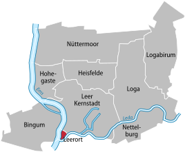  Location of Leerort in the city of Leer
|
|
 The remains of the fortress Leerort in the dike foreland at the confluence of the Ems and Leda
|
|
The village of Leerort is the smallest district of the city of Leer (East Friesland) . Leerort is located at the confluence of the Leda and Ems . Until it was incorporated on February 1, 1971, Leerort was a separate municipality.
history
Leerort is of outstanding importance for East Frisian history . On the strategically located headland between Ems and Leda, the Hamburgers built the fortress Leerort in 1435 , which was expanded from 1453 by the East Frisian counts and lords to form the strongest fortress in East Frisia.
In the Saxon feud , the East Frisians held the fortress against the Brunswick besiegers . When the projectile of the son of a gunner from the other side of the Ems finally killed Duke Heinrich von Braunschweig during a last major attack , the besiegers withdrew.
From 1611 troops were Dutch States-General in the fortress quartered . After East Frisia was taken over by the Prussians in 1744 , the Dutch cleared the fortress. The fortress was finally razed by the Prussians between 1754 and 1760 . Today only meager remains can be seen in the dike foreland .
Origin of name
The name Leerort is made up of the name of the city of Leer and the old Frisian ord which means something like lace. Leerort therefore roughly means: place at the top of the city of Leer.
Web links
- Wilhelm Lange (local chronicle of the East Frisian landscape ): Leerort (PDF file; 858 kB)
Individual evidence
- ^ Federal Statistical Office (ed.): Historical municipality directory for the Federal Republic of Germany. Name, border and key number changes in municipalities, counties and administrative districts from May 27, 1970 to December 31, 1982 . W. Kohlhammer GmbH, Stuttgart / Mainz 1983, ISBN 3-17-003263-1 , p. 262 .
- ↑ Remmers, Arend .: From Aaltukerei to Zwischenmooren: the settlement names between Dollart and Jade . 1st edition Schuster, Leer 2004, ISBN 3-7963-0359-5 , p. 140 .
Core city | Bingum | Heisfelde | Hohegaste | Empty location | Loga | Logabirum | Nettelburg | Nüttermoor