
Leohito
| Leohito | |||

|
|||

|
|||
| Data | |||
| surface | 40.55 km² | ||
| population | 3,159 (2015) | ||
| Chefe de Suco | António Martins Pereira (election 2009) |
||
| Aldeias | Population (2015) | ||
| Aiasa | 557 | ||
| Faloai | 338 | ||
| Ferik Katuas | 864 | ||
| Mohak | 914 | ||
| Rai Ulun | 486 | ||
|
|||

Leohito ( Leohitu, Leo-Hito, Leo-Hutu ) is an East Timorese Suco in the Balibo administrative office ( Bobonaro municipality ).
geography
| Leohito | ||
| places | position | height |
| Aiasa | 8 ° 57 ′ S , 125 ° 5 ′ E | 323 m |
| Beremanu | 9 ° 0 ′ S , 125 ° 5 ′ E | 175 m |
| Besakren | 9 ° 1 ′ S , 125 ° 4 ′ E | 211 m |
| Faloai | 9 ° 0 ′ S , 125 ° 5 ′ E | 279 m |
| Fauk | 8 ° 58 ′ S , 125 ° 5 ′ E | 448 m |
| Ferik Katuas | 9 ° 0 ′ S , 125 ° 4 ′ E | 448 m |
| Chamomiles | 8 ° 58 ′ S , 125 ° 5 ′ E | 324 m |
| Mauleo | 8 ° 59 ′ S , 125 ° 6 ′ E | 132 m |
| Mohak | 9 ° 0 ′ S , 125 ° 4 ′ E | 446 m |
| Nalametan | 8 ° 59 ′ S , 125 ° 2 ′ E | 610 m |
| Only | 9 ° 1 ′ S , 125 ° 4 ′ E | 268 m |
| Rai Ulun | 9 ° 1 ′ S , 125 ° 3 ′ E | 364 m |
| Remian | 9 ° 1 ′ S , 125 ° 3 ′ E | 268 m |
| Ualets | 8 ° 58 ′ S , 125 ° 5 ′ E | 303 m |
| Wiwik | 8 ° 59 ′ S , 125 ° 5 ′ E | 330 m |

Before the 2015 territorial reform, Leohito had an area of 38.65 km². Now it is 40.55 km². Across the Talau River , later called Taipui , lies the Indonesian West Timor in the southeast . The river flows northeast and meets the Malibaca River . From here the river swings northwards as Nunura . At the confluence, Indonesia and Leohito meet the Sucos Leolima (Balibo administrative office) and Tapo / Memo ( Maliana administrative office ). To the northwest of Leohito is the Suco Balibo Vila and to the west of the Suco Cowa . The Tishun waterfall is located in Suco Leohito .
In the center of Sucos are the villages of Ferik Katuas ( Feric Catuas , Ferikatuas , German old wives ), Wiwik , Mohak ( Mohac ), Faloai ( Falo Ai , Falahai , Faluai ) and Beremanu . The places Ualeten , Fauk , Maulelo , Kamileten and Aiasa ( Ai-Assa ) are in the north. In the south are the villages Besakren , Nuren , Remian and Rai Ulun ( Raiulun ). In the extreme northwest is the place Nalametan . There are elementary schools in Kamileten, Mohak and Raiulun. Only simple, small streets connect the villages with the outside world.
In Leohito there are the five aldeias Aiasa , Faloai , Ferik Katuas , Mohak and Rai Ulun .
The Mobusa water reservoir in Suco Leohito ( 9 ° 0 '40 " S , 125 ° 5' 19" O ) is also used to supply the Indonesian village Asumanu . It was built during the 1991 occupation. When a restoration of the reservoir became necessary in 2006, both countries worked together on this project, which is considered a prime example of neighborly cooperation across the border.
The mountain Leohito is outside the Sucos, east of Malibacaflusses.

The Montanhas Brancas in Leohito

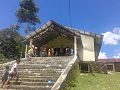
Holy House of Leohito

Cave at the Sacred Tree of Leohito
Church of Leohito

Lake Leohito


Residents

The Suco has 3,159 inhabitants (2015), of which 1,597 are men and 1,562 women. The population density is 77.9 inhabitants / km². There are 608 households in the Suco. Over 75% of the residents state that Bekais is their mother tongue. About 10% speak Kemak , about 5% Tetum Terik and small minorities Tetum Prasa and Baikeno . These languages are also spoken across the border in Indonesian West Timor.
history
As a member of the Camenaça Pact, the kingdom of Leohito took part in the Cailaco rebellion against the Portuguese from 1719 . As a result of the rebellion, the Portuguese moved their colonial capital from Lifau in the west of the island to Dili in the east.
In January 2012, Catholics attacked the followers of a "new religion". The result was 17 injured. Allegedly, the other group had previously insulted priests and nuns.
politics
In the 2004/2005 elections , Andre Mali Maia was elected Chefe de Suco. In the 2009 elections , António Martins Pereira won .
Web links
- Results of the 2010 census for the Suco Leohito ( tetum ; PDF; 8.5 MB)
- Results of the 2015 census for the Suco Leohito (tetum; PDF)
- Seeds of Life: Suco information sheets Balibo (tetum)
Individual evidence
- ↑ a b c d Direcção-Geral de Estatística : Results of the 2015 census , accessed on November 23, 2016.
- ↑ Fallingrain.com: Directory of Cities, Towns, and Regions in East Timor
- ↑ Direcção Nacional de Estatística: Population Distribution by Administrative Areas Volume 2 English ( Memento of the original from January 5, 2017 in the Internet Archive ) Info: The archive link has been inserted automatically and has not yet been checked. Please check the original and archive link according to the instructions and then remove this notice. (2010 census; PDF; 22.6 MB)
- ^ Timor-Leste GIS-Portal ( Memento from June 30, 2007 in the Internet Archive )
- ↑ UNMIT map of the Bobonaro district, August 2008 ( Memento of the original from November 8, 2012 in the Internet Archive ) Info: The archive link was inserted automatically and has not yet been checked. Please check the original and archive link according to the instructions and then remove this notice. (PDF; 535 kB)
- ↑ Jornal da Républica with the Diploma Ministerial n. 199/09 ( Memento of February 3, 2010 in the Internet Archive ) (Portuguese; PDF; 323 kB)
- ↑ Sobar Sutisna and Sri Handoyo: "Delineation and demarcation surveys of the land border in Timor: Indonesian perspective", Center for Boundary Mapping, The National Agency for Surveys and Mapping of Indonesia (BAKOSURTANAL) ( Memento of the original from September 21, 2011 in Internet Archive ) Info: The archive link was inserted automatically and has not yet been checked. Please check the original and archive link according to the instructions and then remove this notice.
- ↑ Results of the 2010 census for the Suco Leohito ( tetum ; PDF; 8.5 MB)
- ↑ History of Timor ( Memento of the original from March 24, 2009 in the Internet Archive ) Info: The archive link was automatically inserted and not yet checked. Please check the original and archive link according to the instructions and then remove this notice. (PDF; 824 kB) - Technical University of Lisbon
- ↑ Suara Timor Lorosa'e: Catholics in Balibo attacks new religion , January 17, 2012
- ↑ Secretariado Técnico de Administração Eleitoral STAE: Eleições para Liderança Comunitária 2004/2005 - Resultados ( Memento of August 4, 2010 in the Internet Archive )
- ↑ Secretariado Técnico de Administração Eleitoral STAE: Eleições para Liderança Comunitária 2009 - Resultados ( Memento of August 4, 2010 in the Internet Archive )
![]() Map with all coordinates: OSM | WikiMap
Map with all coordinates: OSM | WikiMap
The administrative borders within East Timor changed in 2015. This article must therefore be checked and updated if necessary. See New Administrative Boundaries .