
Lichtenwald
| coat of arms | Germany map | |
|---|---|---|

|
Coordinates: 48 ° 45 ' N , 9 ° 29' E |
|
| Basic data | ||
| State : | Baden-Württemberg | |
| Administrative region : | Stuttgart | |
| County : | Esslingen | |
| Height : | 467 m above sea level NHN | |
| Area : | 10.8 km 2 | |
| Residents: | 2694 (Dec. 31, 2018) | |
| Population density : | 249 inhabitants per km 2 | |
| Postal code : | 73669 | |
| Area code : | 07153 | |
| License plate : | ES, NT | |
| Community key : | 08 1 16 037 | |
| LOCODE : | DE LWA | |
| Address of the municipal administration: |
Hauptstrasse 34 73669 Lichtenwald |
|
| Website : | ||
| Mayor : | Ferdinand Rentschler | |
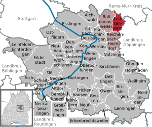
| Location of the municipality of Lichtenwald in the Esslingen district | ||
  |
||

Lichtenwald is a municipality in the Schurwald in the Esslingen district in Baden-Württemberg , on the L1151 road between Reichenbach an der Fils (4 km) and Schorndorf (7 km). It belongs to the Stuttgart region (until 1992 the Middle Neckar region ) and the European metropolitan region of Stuttgart .
geography
Geographical location
The district of Hegenlohe lies on the wooded eastern slope (also called Heuberg among the locals) of the Reichenbachtal and, like Thomashardt, which is located on the edge of the hill, is surrounded by the mixed forests of the Schurwald. The municipality extends from 342 to 480 meters in height.
On the Höhenweg (a hiking trail from the community center to the Naturfreundehaus) you have a wonderful panorama of the Alb and the areas in front of it when the visibility is good. In a south-westerly direction there is a distance of approx. 50 km, to the east of approx. 30 km.
Community structure
Lichtenwald consists of the two districts Hegenlohe and Thomashardt, which emerged from the two formerly independent communities of the same name, from which the community Lichtenwald emerged. The hamlet of Hegenlohe includes the village of Hegenlohe and the houses Bannmühle and Ölmühle as well as the abandoned town of Ritzenweiler. The village Thomashardt belongs to the district Thomashardt. Approx. 66% of the district consists of forest.

Neighboring communities
To the west, Thomashardt borders the community of Baltmannsweiler, also located on the Schurwaldhöhe, with its districts of Baltmannsweiler and Hohengehren. In the south, Reichenbach an der Fils , located in the valley, is neighboring. Again on the Schurwaldhöhe are the neighboring towns of Büchenbronn (to Ebersbach an der Fils ) and Baiereck (to Uhingen ), as well as the neighboring towns of Schlichten (to Schorndorf ) and the north-western towns of Manolzweiler and Engelberg (both to Winterbach ).
Division of space

According to data from the State Statistical Office , as of 2014.
climate
The climate in Lichtenwald is somewhat rougher than in Filstal . During the day, there can be a temperature difference of 1–3 K compared to the valley. This decreases in the evening, and in summer, as the warm air rises from the valley after sunset, a reversal of the effect can be observed. In general, it is windier in Lichtenwald than in the valley, as the places are on a mountain ridge. In winter, like all over the Schurwald, there is more and longer snow than in the Fils, Neckar or Remstal valleys . Due to the mountain location and the (almost) unobstructed view to the west and east, you can use almost the full amount of sunshine in Lichtenwald.
geology
The geological structure of the Lichtenwald follows the same pattern that can be found in most of the rest of the Schurwald.
The Lichtenwald ridge consists of a very narrow zone (20-25 m) of the Black Jurassic or (lower) Lias alpha . This in turn consists of a layer of weathering products such as dark loam , clays and sand , including a. the light gray Angulate sandstone and deeper again (but no longer visible, because it is hidden under the rubble) the psilon note . Apart from their stony edges, the lias soils are good arable soils.
The other layers belong to the Keuper. Under the Lias alpha layer, a 2-3 m thick layer of Rhät begins (dark, clayey, marly, but difficult to see). The clayey marl adjoins the Rhät as a 20–30 m thick layer and is immediately visible as a 50–300 m wide, humped meadow area between the fields above and the edge of the forest below.

The marl does not provide a good foundation and tends to swell when it rains, which can lead to landslides. Typical consequences of the ground movements are the many trees that are inclined or that grow towards the light with a kink in the lower part of the trunk, which is also referred to as cane growth or saber growth.
The lowest layer of the Schurwald consists of Stubensandstein (Middle Keuper) with a layer thickness of 90-100 m. This formation consists largely of sandstone banks in which numerous streams have cut.
tectonics
The geological layers in the Schurwald generally dip from the northwest to the southeast by about 0.5–1 °. Furthermore, today's Filstal in the Reichenbach-Plochingen area is a fracture zone caused by extreme stresses. As a result of the subsidence of the zone, in Reichenbach, for example, Stubensandstein layers lie 50–70 m deeper than north of the fault line. The tensions have not subsided to this day, which explains a tectonic earthquake in August 1940, the epicenter of which was about 10 km below Hegenlohe (although it did not cause any damage, it was felt all over the Schurwald).
history
Lichtenwald from 1971
The municipality of Lichtenwald was created on January 1st, 1971 through the voluntary amalgamation of the previously independent municipalities of Hegenlohe and Thomashardt. In a referendum on December 13, 1970, with a high turnout, more than 90% of the electorate voted in favor of the union.

The name Lichtenwald comes from the "light forest", a designation that appeared in the old forest warehouse books of the Schorndorf Forestry Office in 1555 with reference to the communities of Hegenlohe and Thomashardt. The components of the place names, Lohe and Hardt, can also be traced back to the terms pasture forest or light forest . The long-established citizen Karl Roos from Thomashardt ultimately had the brilliant idea for the naming. Other proposals that were rejected were: Hegenhardt, Thomaslohe, Schlichtenwald, Hohenlau, Schurdorf, Langgehren and Langrain.
Several public building projects have been implemented in Lichtenwald since the 1990s. After the town hall and the village square in Thomashardt had first been redesigned, the water tower in Thomashardt was artistically designed in 1996, for which over 55,000 DM had been raised through donations from individuals, from charity events and sponsors from the economy. In 1998 the youth center at the elementary school was inaugurated, and in October 2000 the community center was completed, in which the volunteer fire brigade , building yard and a community hall for clubs and cultural events are housed. In 2003 a new sports field was built. In 2012 the new multi-purpose hall (community and sports hall) was added. The old sports and community hall was demolished in 2012 because it was in dire need of renovation, far too small and no longer meets today's requirements for such a building.
Hegenlohe


Hegenlohe was first mentioned under the name Haginilo on April 26, 1173 , when the antipope Calixt III. confirmed the properties of the Sankt Blasien monastery ( southern Black Forest ) in Hegenlohe. The dukes of Teck had the bailiwick until 1364 . Later the bailiwick of Hegenlohe was handed over to the Counts of Württemberg, who gave it to the Holdermann family in Esslingen, among others. In 1457 the bailiwick fell back to the Württemberger, who then assigned the place to the office (since 1806 Oberamt) Schorndorf . The municipality has belonged to the Esslingen district since the regional reform of 1938 . Until 1379, the settlement of Ritzisweiler, mentioned around 1140, existed on the Hegenloher mark. Another settlement called Witzenweiler existed until before the Thirty Years War.
Thomashardt and Hegenlohe always formed a total parish. Around 1700 the municipality of Hegenlohe began to introduce its own school lessons, previously the school-age children (only boys, girls only from 1739) had to attend lessons in Thomashardt and Hohengehren.
Holy Cross Church
An Ecclesia (more likely a chapel ) was first mentioned in a document in 1173. The present sacristy was built after 1200, the ribbed cross vault was drawn in much later. The Protestant parish church of the Holy Cross, which is based on a rocky hilltop, was probably completed in 1479, although the interior has undergone several changes over the centuries, most recently in 1955. The stone table altar probably comes from the first chapel, there is one on the north wall Gothic baptismal font and in the flat-roofed nave again on the north wall a late Gothic sacrament niche (from 1479). The wooden altar crucifix was carved by an unknown hand around 1520 and restored in 1955. Probably the first organ already existed around 1700, the current one dates from 1835.
The church tower is 29 m high, rests on two sides on a strong, self-supporting, medieval oak construction and was completely rebuilt in 1809 on the upper two floors together with the tower roof. The first large church bell from 1501, cast by the Esslingen bell caster Sydler and weighing almost 300 kg, had to be cast in 1949 due to a crack. Previously it was confiscated during World War II and transported to Esslingen, but was returned in 1947. A small bell was last cast in 1832, melted down during the First World War in 1917 and replaced by a new one in 1922. A third bell, the christening bell, was purchased in 1949. The bells ring in ega (big bell - small bell - baptismal bell).
Thomashardt


Thomashardt first appeared in a document dated November 18, 1324 in the form of the name Dagemanshart. Part of the village was owned by the Counts of Aichelberg until 1333 , while another part was owned by the Dukes of Teck until 1367 . Later the Counts of Württemberg owned the respective rights. The third part of the village belonged from 1268 to the Adelberg Monastery , which transferred its bailiwick rights to Württemberg in 1362. The monastery itself ruled until 1535. Since 1453 the community belonged to the office of Schorndorf and from 1938 to the district of Esslingen .
Thomashardt had neither a parish nor a church building until 1966, when the Church of the Resurrection was built in 1965/66. The education sector developed earlier than in Hegenlohe, a school building was built in 1812, which was also used as the town hall.
Common history before 1971
Even before 1971 there were many similarities between Thomashardt and Hegenlohe. Between 1560 and 1819, both communities belonged to the Schlichter Forest Court and in 1819, together with Schlichten and Baiereck, even formed a community with its seat in Thomashardt. After Baiereck and Schlichten left the association, the two remaining suburbs separated on September 29, 1825 and thus found their independence again. Even before they merged again in 1971, Thomashardt and Hegenlohe formed a school association. In 1962 a school building was erected on the border of the Mark, in which the primary school is located today.
Population development
Lichtenwald from 1971
The population has grown within 30 years from 1351 in 1971 to 2572 in 2004, of which 1360 people are in the district of Hegenlohe and 1212 in the district of Thomashardt. On March 31, 2015, according to the official population statistics of the municipal administration, there were 2559 inhabitants in Lichtenwald (Hegenlohe: 1424 inhabitants, Thomashardt: 1132 inhabitants). As a result of the strong population growth, new residential areas had to be created and many new roads with supply and disposal lines had to be built. In 1999/2000 the mixed and (restricted) industrial area Ummerles Häule III in Hegenlohe was developed. In 2004/2005, the Hohenrain / Gassenäcker residential area in Hegenlohe was developed. In autumn 2013, the development of the Thomashardt-Ost building area in the district of the same name was completed with a roundabout at the northern entrance to the town, which includes a separate residential and commercial area.
Hegenlohe
From the 17th to the 19th century, the place developed very slowly. The reasons for this are on the one hand the geographical location and on the other hand the devastating wars. The population rose from 40 after the Thirty Years' War to around 80 in 1702. In the 19th century, the number of residents in the municipality fluctuated between 278 and 371. Due to the refugees after the Second World War , the population jumped by 30% 411 people (up from 316 in 1939). By 1961 the community grew by 14% to 475 citizens.
Thomashardt

Thomashardt used to have more community residents than Hegenlohe, although the percentage fluctuations matched Hegenlohe. In the 19th century the community had between 309 and 414 inhabitants. After the end of World War II, the population grew by 32% to 433 people (from 327 in 1939). By 1961 the population increased by 20% to 545.
politics
coat of arms
Official blazon : “In gold (yellow) above a green three-mountain, a red beech tree pointing obliquely downwards to the left on a green stem with a green leaf pointing obliquely to the left , crossed with an obliquely downwardly pointing red acorn with a green cap on a green stem with an obliquely upward pointing green leaf. "
The new coat of arms could only be used from December 13, 1971 (almost a year after Lichtenwald was founded). A previously announced competition in the community did not produce any useful results for the coat of arms, but important suggestions came from the Stuttgart archives. Regarding the interpretation of the coat of arms, the authority says: “The coat of arms contains simplified depicted components of the two earlier local coats of arms that were extinguished with the merger. These components, an oak leaf with an acorn for Hegenlohe and a beech leaf with a beech tree for Thomashardt, are connected in the manner of an oblique quatrefoil and are intended to indicate the commonality achieved by the two parts of the community. At the same time, this motif, derived from the virgin forest flora, can be associated with the new community name. In the new coat of arms, as in the two earlier ones, the Green Dreiberg reminds of the topographical location of the community in the Schurwald area. "
mayor
Ferdinand Rentschler was re-elected in February 2019 with 70.54% of the vote.
Municipal council

The municipal council in Lichtenwald has 12 members. The local elections on May 26, 2019 led to the following final result. The municipal council consists of the elected voluntary councilors and the mayor as chairman. The mayor is entitled to vote in the municipal council.
| Parties and constituencies |
% 2019 |
Seats 2019 |
% 2014 |
Seats 2014 |
||
| LBL | Lichtenwald Citizens List | 49.95 | 6th | 46.65 | 6th | |
| CDU | Christian Democratic Union of Germany | 28.34 | 3 | 28.02 | 3 | |
| FUW | Free Independent Voters | 21.71 | 3 | 25.33 | 3 | |
| total | 100.0 | 12 | 100.0 | 12 | ||
| voter turnout | 69.13% | 63.75% | ||||
Economy and Infrastructure
history
Up until the beginning of the 20th century, agriculture and forest use were the main sources of income for the residents of both communities, and charcoal burning was also introduced. Craftsmen met local needs. The two mills in Reichenbachtal were the largest commercial enterprises for centuries. On the one hand there was the ban mill for grain, on the other hand the oil mill, which is later used as a bone mill and today as a sawmill .
Employment in agriculture has been falling steadily since 1930. Most of the residents now commute to work in the cities (in 1987 79.6% of the 1,172 gainfully employed people from Lichtenwald worked in the cities in the Neckar and Filstal valleys). In Hegenlohe, for example, the number of residential buildings increased by 150% between 1945 and 1969. The infrastructure (such as the water supply and the sewerage system) could be significantly improved and expanded in the 1950s due to the better income situation and the resulting increase in tax revenue. By expanding the hiking trails , the opportunity for local recreation was also strongly promoted. In this way, today's Lichtenwald changed from two farming villages to a lively residential community.
Current
The resident companies offer around 130 jobs in Lichtenwald, of which the municipality is the largest employer. Thus, Lichtenwald is primarily a residential and commuter community. By designating the Thomashardt-Ost construction area with a commercial part, it is hoped that additional jobs will be created on site as well as increasing trade tax revenues. Around 50% of the existing commercial building sites have already been sold and will be developed shortly. Few large farms and part-time businesses cultivate the approx. 286 ha of arable land.
There have been shopping opportunities in town since the "Thomashardt-Ost" industrial park was completed. At the beginning of May 2014, a supermarket with 840 m² sales area, a drinks market and a bakery branch with a standing cafe was opened there. Fruit, vegetables, sausage products and fresh milk can be bought from local farmers.
In the 1990s there was still a "mom and pop" shop in every district, but they had to be closed due to inefficiency. Two bank branches (Volksbank and KSK Esslingen-Nürtingen) were also closed. There is a branch of the KSK Esslingen in Thomashardt.
Election results
|
Political party |
Federal Parliament election 2002 |
Bundestag election 2005 |
Bundestag election 2009 |
Bundestag election 2013 |
Bundestag election
2017 |
|---|---|---|---|---|---|
| CDU | 39.8% | 37.9% | 31.4% | 47.8% | 37.04% |
| SPD | 35.7% | 30.4% | 18.1% | 19.8% | 13.79% |
| Green | 10.4% | 9.8% | 14.3% | 9.8% | 12.25% |
| FDP | 8.9% | 13.3% | 23.4% | 7.4% | 16.64% |
| AFD | - | - | - | 4.7% | 11.80% |
| PDS, from 2009 Die Linke | - | 3.4% | 5.5% | 3.6% | 4.16% |
| The Pirates | - | - | - | 2.3% | 0.46% |
| Animal welfare party | - | - | - | 1.4% | 1.25% |
| NPD | 0.2% | 0.8% | 0.6% | 1.0% | 0.34% |
| ÖDP | - | - | - | 0.5% | 0.29% |
| Free voters | - | - | - | 0.2% | 0.34% |
| Animal Welfare Alliance | - | - | - | - | 0.17% |
| REP | 1.3% | 2.0% | 1.5% | - | - |
| PBC | 0.6% | 0.5% | 0.4% | - | - |
| THE PARTY | - | ? | - | ? | 0.63% |
| voter turnout | 89.2% | 87.78% | 81.4% | 84.6% | 86.22% |
The Lichtenwald community has always had a very good turnout in the last elections . For example, in the 2005 federal election , Lichtenwald had the sixth highest voter turnout of all municipalities in Baden-Württemberg, at 87.78% .
Culture and sights
Despite the rather modest size, there is a cultural program in Lichtenwald. In 2003 there were around 8,000 visitors, more than half from outside the city. The local artists have a decisive influence on the cultural program and the image of the community. The water tower is the best example of this, as it caused a sensation far beyond the district with its ceramic tile mosaic. The cultural program has a different motto every year, in 2004 the themes of Eduard Mörike and EU expansion . In June 2004, for example, there was an international inlay exhibition with artists from France , Poland , the Czech Republic and Russia .
Well-known artists in and from the town are the actor Ernst Specht, the pianist Martin Pillwein, his wife and artist Carmen Pillwein, the inlay artist Eberhard Scheihing, the artist couple Angie and René Heinze, the pianist Gunhilde Cramer, the soprano Constanze Seitz, the baritone Walter Grupp, the artist Dieter Meyer-Jacobi, the sculptor Bertram Seitz or the juggler Andreas Wittig.
Lichtenwald Adult Education Center
Due to the precarious financial situation of the community, the VHS Lichtenwald successfully spun off from the solidarity association of the VHS Esslingen in 2003/04 and is now integrated into the community administration. From a financial point of view, material costs are covered, but not personnel costs. The VHS in Lichtenwald not only stands for pure teaching, but also integrates a complete cultural program and a children's program. Around 3,000 people took part in the program in the first semester, many of them from the Waiblingen, Göppingen and Esslingen areas.
Sights and natural monuments

In Hegenlohe, the Protestant parish church , which was completed in 1479, has a parsonage and parish barn and the neighboring bakery . The main attractions in Thomashardt are the redesigned village square with town hall and the artistically designed water tower with a platform that can be climbed and a wonderful view of the Swabian Alb , from Hohenstaufen to Hohenzollern . In the upper area of the tower, the local artist couple Heinze installed a colorful ceramic tile mosaic in the shape of water droplets.
Several trees or groups of trees in Lichtenwald are considered natural monuments. This includes the village linden tree next to the church in Hegenlohe, which was planted around 1800 and has a circumference of 3.2 meters at a height of 20 meters. This tree had to be felled in spring 2012 due to the lack of stability due to an almost completely hollow trunk. A new linden tree was planted in the same place. Another natural monument is the Schönbrückleseiche approx. 800 m east of Hegenlohe in the forest, which is over 330 years old, 45 meters high and has a circumference of 4.3 meters. Also worth mentioning is the linden avenue near Thomashardt with (still) 38 trees that are around 30 m high and 170 years old.
Events
Regular annual major events in Lichtenwald are the theater performances by the theater department of TSV-Lichtenwald in January in the community hall and the Lichtenwald half-marathon, which with around 1000 participants and guests is by far the largest event in Lichtenwald. The VHS Lichtenwald (see above) also organizes numerous lectures. The various associations (Edelweiß hiking association, church choir, choral society, etc.) also contribute to community life with annual festivals.
literature
- Manfred Langhans: Hegenloher Heimatbuch. 1969
- Manfred Langhans: The Schurwald: Land u. People once u. now. 2nd edition Kohlhammer, Stuttgart, ISBN 3-17-005680-8 , 1980
- Lichtenwald, Hegenlohe and Thomashardt, pictures from days gone by. Illustrated book, Geiger-Verlag, Horb aN 1985
- Friedrich Karl Reuß (Ed.): So ebbes !, anecdotes from Hegenlohe, Thomashardt and Schlichten. Compiled by the municipality of Lichtenwald, Schneider Verlag, Hohengehren 2004, ISBN 3-89676-843-3
- The district of Esslingen - published by the Baden-Württemberg State Archives. V. with the district of Esslingen, Jan Thorbecke Verlag, Ostfildern 2009, ISBN 978-3-7995-0842-1 , volume 2, page 165
Web links
Individual evidence
- ↑ State Statistical Office Baden-Württemberg - Population by nationality and gender on December 31, 2018 (CSV file) ( help on this ).
- ↑ Main statute of the municipality of Lichtenwald from December 17, 1996 ( Memento of the original from July 24, 2004 in the Internet Archive ) Info: The archive link was automatically inserted and not yet checked. Please check the original and archive link according to the instructions and then remove this notice.
- ^ The state of Baden-Württemberg. Official description by district and municipality. Volume III: Stuttgart District, Middle Neckar Regional Association. Kohlhammer, Stuttgart 1978, ISBN 3-17-004758-2 . Pp. 243-245
- ↑ State Statistical Office, area since 1988 according to actual use for light forest.
- ^ Federal Statistical Office (ed.): Historical municipality directory for the Federal Republic of Germany. Name, border and key number changes in municipalities, counties and administrative districts from May 27, 1970 to December 31, 1982 . W. Kohlhammer, Stuttgart / Mainz 1983, ISBN 3-17-003263-1 , p. 448 .
- ↑ https://www.esslinger-zeitung.de/region/kreis_artikel,-buergermeisterwahl-in-lichtenwald-_arid,2242503.html
- ↑ Election information for the municipal data center
- ↑ KDRS: Election results for the 2017 federal election. Accessed on September 25, 2017 .

Aichtal | Aichwald | Altbach | Altdorf | Altenriet | Baltmannsweiler | Bempflingen | Beuren | Bissingen on the Teck | Deizisau | Denkendorf | Dettingen under Teck | Erkenbrechtsweiler | Esslingen am Neckar | Filderstadt | Frickenhausen | Großbettlingen | Hochdorf | Holzmaden | Kirchheim unter Teck | Kohlberg | Kings | Leinfelden-Echterdingen | Lenningen | Lichtenwald | Neckartailfingen | Neckartenzlingen | Neidlingen | Neuffen | Neuhausen on the Fildern | Notzingen | Nürtingen | Oberboihingen | Ohmden | Ostfildern | Owen | Plochingen | Reichenbach an der Fils | Schlaitdorf | Unterensingen | Weilheim an der Teck | Wendlingen am Neckar | Wernau (Neckar) | Wolfschlugen