
List of architectural monuments in Augsburg

The monuments of the Bavarian district capital Augsburg are compiled on this page . This table is a partial list of the list of architectural monuments in Bavaria . The basis is the Bavarian Monument List , which was first drawn up on the basis of the Bavarian Monument Protection Act of October 1, 1973 and has since been managed by the Bavarian State Office for Monument Preservation . The following information does not replace the legally binding information from the monument protection authority.
List of architectural monuments by city district
There are around 1250 architectural monuments and 20 ensembles in Augsburg. For a better overview, the monuments and ensembles are divided into partial lists for the individual districts of Augsburg , which are listed in the following sorted according to planning areas. You can switch between the lists of monuments of the city districts using a navigation bar sorted by the city district numbers. The city fortifications are cross-city districts and are shown on this page.
City fortifications Augsburg
A distinction must be made between the fortifications of the Roman settlement Augusta Vindelicorum , the cathedral city of the early Middle Ages, and the imperial city. The walls of the Roman complex are no longer upright.
The walling of the cathedral city from the 10th century was renewed in brick in the 14th century. Remaining wall sections on the north side of the cathedral city have been preserved at Anoßgäßchen 3, Frauentorstraße 8 and south of the Äußere Pfaffengäßchen.
The imperial city fortifications, which bordered the urban space between the cathedral city and Ortisei and Afra by 1272 at the latest and also the Frauen- und Jakobervorstadt up to the middle of the 14th century, were largely abandoned after the city was devastated in 1860. On the long west flank of the old town you can still see the former guided tour on the Konrad-Adenauer-Allee, Schießgrabenstraße, Fuggerstraße, Volkhartstraße (see Ensemble Altstadt Augsburg and Ensemble Fuggerstraße / Volkartstraße / Schaezlerstraße); The rest of the ramparts exist on Schießgrabenstrasse (see Ensemble Schießgrabenstrasse).
On the north side are preserved:
- the Wertachbrucker Tor ( location ) renewed by Elias Holl in 1605 and small remains of the wall ( location )
| location | object | description | File no. | image |
|---|---|---|---|---|
| At oven wall 2 ( location ) |
Wertachbruck Gate | Two-storey substructure with pointed arches, on the field side a low front gate with arched passage, upper storeys structured by an octagonal base with Tuscan order and tent roof with lantern, substructure from the late Middle Ages, raised and expanded in 1605 by Elias Holl
Part of the city wall, medieval |
D-7-61-000-1114 |
 more pictures |
- further east is the modernly restored Fischertor from 1924/25 (see Am Fischertor 10)
| location | object | description | File no. | image |
|---|---|---|---|---|
| Am Fischertor 10 ( location ) |
Fisherman's gate | Three-part hipped roof building with a central arched passage and side passages, built in place of the gate building, which was converted by Elias Holl in 1609, 1924/25
Apartment block, connected to the Fischertor, three-storey eaves side building with gable roof, tail gables and corner bay windows, in baroque forms, by Otto Holzer, 1923/24 |
D-7-61-000-1000 |
 more pictures |
- then a train of the city wall ( location ) to the Lueginsland bastion, which was converted into a citadel in 1702/04
- Bastion Lueg ins Land ( Lage ), high rampart at the northeast corner of the city fortifications, laid out around 1430 and 1540, expanded in 1704, Vorwerk bez. 1553
- then to the south, the city wall of the 15th century, partly with a moat

Wertachbrucker Tor, front gate

Remnants of the wall at the oven wall 2

City wall north of the Fischertor

City wall north of the Fischertor

City wall north of the Fischertor

City wall north of the Fischertor

City wall north of the Fischertor

City wall north of the Fischertor
Bastion Lueg into the country


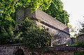
The east side of the city still shows the old north-south fortification line, which is fragmentarily documented in individual wall remains and fortification towers, and which is clearly visible in the moats:
- eastern part of the city wall, remains of blind arches on the city side, probably 15th century.
- So-called Schwedenstiege ( location ), connecting wall between the city wall on Schwedenweg and the Untere Graben
- Defense tower ( location ), brick building, 15. – 17. Century
- Defense tower ( location ), brick building, 15. – 17. Century
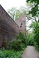
northern tower on Schwedenweg, field side

southern tower on Schwedenweg, field side

north and south tower on Schwedenweg, city side

Schwedenstiege from the north
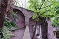
Schwedenstiege from the south


In addition, important parts of the younger fortification ring of Jakobervorstadt connected to the east have been preserved:
- City moat from the western end of Bert-Brecht-Strasse to Jakoberstrasse ( location )
- Oblatterwall, earthfill created in 1540 on the northeast corner of Jakobervorstadt ( location )
- low wall with loopholes, towards the moat, 1540
- Rest of the city wall, adjoining the wall to the south and west, partly with battlements, 15th century ( location )
- Fünfgratturm (freestanding since the demolition of the associated city wall), four-storey rectangular floor plan with four round watch towers and high tent roof, blind arches on the north side, probably around 1430/32 (dendro.dat.)
| location | object | description | File no. | image |
|---|---|---|---|---|
| Lower Jakobermauer 30 ( location ) |
Five ridge tower | Four-sided with four round watch towers and a high tent roof, blind arches on the north side, probably 1454, see also city fortifications | D-7-61-000-484 |
 more pictures |
- the monumental Jakobertor at the eastern exit of the city
| location | object | description | File no. | image |
|---|---|---|---|---|
| Lower Jakobermauer 2 and 4 ( location ) |
Train the city wall | To the north of the Jakobertor, 15th century, reconstruction after 1944 | D-7-61-000-484 |

|
| Jakoberstraße 79 ( location ) |
Jakobertor | Brick building with four-sided substructure with pointed arches, two-storey octagonal superstructure with tent roof and square front gate with gable roof, mid-15th century, reconstruction after 1944 | D-7-61-000-484 |
 more pictures |
- Fortification tower, three-storey brick building with a tent roof over a semicircular floor plan, 1540, changes in 1625 and 1742
- Jakoberwall, high earthfill with neck ditch created on the eastern corner of Jakobervorstadt, 1540/42 ( location )
- Defense tower, three-storey brick building with a semicircular floor plan, with laterally adjoining, lower residential buildings, in the core 1458, 1540/42, changed after 1945 ( location )

Defense tower on Jakoberwall

- Rest of the city wall with a covered battlement preserved over two arches, on the south side, 15th century
- City moat from Jakoberstraße to Vogeltorplatz
- Bird gate
| location | object | description | File no. | image |
|---|---|---|---|---|
| Am Vogeltor 1 ( location ) |
Bird gate | Four-storey brick building on a square floor plan with pointed arched, arched gate passage, above it on the field side wall paintings, upper floors with pilaster strips and pointed arch frieze, 1445, after fire in 1944 rebuilding with high hipped roof in 1954 | D-7-61-000-1052 |
 more pictures |
- to the west, arched wall over the city moat with covered battlement, 1485, connection to the gate 1966
| location | object | description | File no. | image |
|---|---|---|---|---|
| Am Vogeltor 1 ( location ) |
Arched wall | Across the city moat with a covered battlement, then to the west, 1485, connection to the 1966 gate | D-7-61-000-1052 |
.jpg) more pictures |
The Red Gate is the most important preserved fortification in the city, the only surviving one on the south side (see Am Roten Tor 5).
- Red gate wall and wall as well as parts of the city wall, 1545/46
- Fortification towers built in the early 17th century are also nearby
- Bridge in front of the Red Gate, two-storey
| location | object | description | File no. | image |
|---|---|---|---|---|
| Am Roten Tor 5 ( location ) |
Red Gate | Erected above a Gothic building, square substructure with pointed arches, upper floor with rounded corners, pilasters and horizontal plaster strips, tent roof with lantern, by Elias Holl , 1622 | D-7-61-000-60 |
 more pictures |
| Am Roten Tor 5 ( location ) |
Front gate | low gate with tent roof and barrel-vaulted passage, 1545/46 | D-7-61-000-60 |
.jpg) more pictures |
| Am Roten Tor 5 ( location ) |
Wallbastei | with arched casemates, 1611 | D-7-61-000-60 |
.jpg) more pictures |
| Am Roten Tor 1 to 5 (ungroup), Rote-Torwall-Straße 11 ( location ) |
Red gate wall and wall | as well as parts of the city wall, 1545/46 | D-7-61-000-60 |
 more pictures |
| Rote-Torwall-Straße 11 ( location ) |
Bridge in front of the Red Gate | two-storey with six arches, marked "1777" | D-7-61-000-60 |
 more pictures |
| Am Roten Tor 5 ( location ) |
Wall systems with bastion | After the fortress status was abolished in the second half of the 19th century, it was converted into a park, which underwent several designs (the last one in 1952 by Ludwig Römer). The open-air stage was also installed here in 1929 . | D-7-61-000-60 |
 more pictures |
File number D-7-61-000-1.
Publications
The list of architectural monuments in Augsburg is part of the Bavarian Monument List , which is maintained by the Bavarian State Office for Monument Preservation . Based on this list, Augsburg's architectural monuments have also been published in book form in the Monuments in Bavaria series .
In the first part of this series, which shows the monuments sorted by government district, the Augsburg monuments are part of Volume VII on Swabia. Volume VII.83 is dedicated to Augsburg in the third part, which provides a separate volume for the monuments of each district and each district-free city , which in turn is divided into sub-volumes. In this part there is a short description and at least one illustration for each monument.
See also
Remarks
- ↑ This list may not correspond to the current status of the official list of monuments. The latter can be viewed on the Internet as a PDF using the link given under web links and is also mapped in the Bavarian Monument Atlas . Even these representations, although they are updated daily by the Bavarian State Office for Monument Preservation , do not always and everywhere reflect the current status. Therefore, the presence or absence of an object in this list or in the Bavarian Monument Atlas does not guarantee that it is currently a registered monument or not. The Bavarian List of Monuments is also an information directory. The property of a monument - and thus the legal protection - is defined in Art. 1 of the Bavarian Monument Protection Act (BayDSchG) and does not depend on the mapping in the Monument Atlas and the entry in the Bavarian Monument List. Objects that are not listed in the Bavarian Monument List can also be monuments if they meet the criteria according to Art. 1 BayDSchG. Early involvement of the Bavarian State Office for Monument Preservation according to Art. 6 BayDSchG is therefore necessary in all projects.
literature
- Bernt von Hagen, Angelika Wegener-Hüssen: City of Augsburg (= Bavarian State Office for Monument Preservation [Hrsg.]: Monuments in Bavaria . Volume VII.83 ). Karl M. Lipp Verlag, Munich 1994, ISBN 3-87490-572-1 .
- Bernd-Peter Schaul: Swabia . Ed .: Michael Petzet , Bavarian State Office for the Preservation of Monuments (= Monuments in Bavaria . Volume VII ). Oldenbourg, Munich 1986, ISBN 3-486-52398-8 .
Web links
- List of monuments for Augsburg (PDF) at the Bavarian State Office for Monument Preservation
- Bavarian Monument Atlas (cartographic representation of the Bavarian architectural and ground monuments by the Bavarian State Office for Monument Preservation (BLfD) )
Amberg | Ansbach | Aschaffenburg | Augsburg | Bamberg | Bayreuth | Coburg | Erlangen | Fürth | Yard | Ingolstadt | Kaufbeuren | Kempten (Allgäu) | Landshut | Memmingen | Munich | Nuremberg | Passau | Regensburg | Rosenheim | Schwabach | Schweinfurt | Straubing | Willows in the Upper Palatinate | Wurzburg