
Rettenbach market
| coat of arms | Germany map | |
|---|---|---|

|
Coordinates: 47 ° 57 ' N , 10 ° 24' E |
|
| Basic data | ||
| State : | Bavaria | |
| Administrative region : | Swabia | |
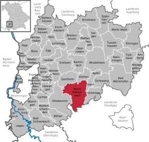
| County : | Unterallgäu | |
| Height : | 679 m above sea level NHN | |
| Area : | 51.49 km 2 | |
| Residents: | 3859 (Dec. 31, 2019) | |
| Population density : | 75 inhabitants per km 2 | |
| Postal code : | 87733 | |
| Primaries : | 08392, 08269 | |
| License plate : | MN | |
| Community key : | 09 7 78 168 | |
| LOCODE : | DE MT3 | |
| Market structure: | 35 parts of the community | |
Market administration address : |
Ottobeurer Str. 10 87733 Markt Rettenbach |
|
| Website : | ||
| Mayor : | Martin Hatzelmann ( CSU / ÜWG ) | |
| Location of the Markt Rettenbach market in the Unterallgäu district | ||
  |
||


Markt Rettenbach is a market in the Swabian district of Unterallgäu .
geography
Markt Rettenbach is located 20 kilometers from Memmingen and Mindelheim in the Donau-Iller region in Upper Swabia .
Expansion of the municipal area
The municipality consists of the districts Markt Rettenbach, Engetried, Eutenhausen (area code 08269), Frechenrieden, Gottenau, Holzerwald, Lannenberg, Mussenhausen (area code 08269) and Wineden.
The municipality has 35 officially named municipal parts (the type of settlement is given in brackets ):
|
|
|
|
In contrast to the municipality, Fleaweed has the zip code 87671, Krautenberg the zip code 87724.
The lowest points of the municipality are each about 632 m high on the northern municipality border to Sontheim, where the Schwelk and the Eastern Günz leave the municipality. The highest point is about 804 m above sea level near Fleaweed on the municipal border to Ronsberg.
history
Until the 19th century
The area around Rettenbach has been populated since the 6th and 7th centuries. A "Rotinbach" is first mentioned in documents in the Ottobeurer monastery books in 1152 . From 1547 Rettenbach was ruled by the future princes Fugger-Babenhausen. In 1790 Rettenbach received market rights with important proprietary rights. With the Rhine Confederation Act in 1806, the place became part of Bavaria, but the Fugger princes had significant reservation rights until 1848.
Name change
On December 18, 1901, the community was renamed Markt Rettenbach .
Incorporations
In the course of the regional reform on July 1, 1971, the previously independent municipality of Lannenberg was incorporated. Wineden joined the company on July 1, 1972. Engetried, Eutenhausen, Frechenrieden, Gottenau and Mussenhausen followed on May 1, 1978.
Population development
| year | 1961 | 1970 | 1987 | 1995 | 2000 | 2005 | 2010 | 2015 |
| Residents | 3279 | 3226 | 3282 | 3636 | 3652 | 3701 | 3644 | 3777 |
Between 1988 and 2018 the community grew from 3,348 to 3,884 by 536 inhabitants or 16%.
politics
Municipal council
Of the 16 seats in the municipal council, after the municipal council election on March 15, 2020 , the CSU / ÜWG and the Bunte Liste will each have eight seats. Compared to the previous term of office from 2014 to 2020, CSU / ÜWG lost a mandate to the Bunte Liste.
mayor
Martin Hatzelmann (CSU / ÜWG) has been mayor since May 1, 2020; he had no competitor and received 92.6% of the vote. His predecessor with a term of office of 36 years - May 1, 1984 to April 30, 2020 - was Alfons Weber, born in 1955 (also CSU / ÜWG). He was last confirmed in office in 2014 with 85.6% of the valid votes.
coat of arms
The coat of arms was approved on December 16, 1866 by King Ludwig II of Bavaria .
Blazon : “Divided by gold, red and blue obliquely to the left; in the red field a silver oblique wave bar, in the gold a blue star, in the blue two silver stars. "
The silver sloping wave bar in the red field stands for the place name "Rotinbach" or "Röttebach", which comes as a stream from the Rotmoos. In the zeitgeist of the time, the silver and blue stars refer to “the happiness of being a Bavarian citizen”. The field colors gold and blue refer to the main colors in the coat of arms of the Fugger family and are reminiscent of the more than 300 years of Fugger rule over the place. Probably based on the older coat of arms of the Fugger market in Babenhausen, the municipal coat of arms from 1866 was still provided with a wall crown and two pennants above the shield head. The heraldic pennant on the right is quartered gold and blue and alternately colored with the Fugger lily; the left heraldic is gold and black quartered. Both pennants are provided with a red or blue label and symbols of attachment to the former rulers.
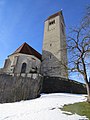
Attractions

- Fugger Castle
- Zehentstadel (formerly warehouse)
- Church of St. Jakobus the Elder , a station on the Bavarian-Swabian Jakobusweg
- Stone rock
- Schlössle in Gottenau
- Former castle mill in Rettenbach with half-timbered gable
Economy and Infrastructure
economy
In 2016 there were 18 employees in agriculture and forestry, 211 in manufacturing and 80 in trade, transport and hospitality at the place of work. In other economic sectors 201 people were employed at the place of work subject to social security contributions. There were a total of 1522 employees at the place of residence subject to social insurance contributions. There were three companies in the manufacturing sector and eight in the construction sector. In 2010 there were 111 farms with a total of 2898 ha of agricultural land, of which 2407 ha were permanent green space.
education
In 1999 the following institutions existed:
- Three kindergartens with a total of 181 kindergarten places and 152 supervised children
- Two elementary schools with a total of nine teachers and 170 students

Eutenhausen from the north
Church in Engetried
Flea herb

Gottenau and Frechenrieden
Griesthal

Günztal south of Engetried
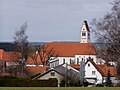
Rettenbach market

Markt Rettenbach from the west

Mussenhausen monastery church

Wineden


Personalities
- Georg Stibi (1901–1982), German politician, journalist and diplomat, ambassador of the GDR in Romania (1957–1958) and Czechoslovakia (1958–1961) and Deputy Foreign Minister of the GDR (1961–1974), born in Markt Rettenbach
Web links
- Entry on the coat of arms of Markt Rettenbach in the database of the House of Bavarian History
- Markt Rettenbach: Official statistics of the LfStat (PDF file; 1 MB)
Individual evidence
- ↑ "Data 2" sheet, Statistical Report A1200C 202041 Population of the municipalities, districts and administrative districts 1st quarter 2020 (population based on the 2011 census) ( help ).
- ^ Community Markt Rettenbach in the local database of the Bavarian State Library Online . Bavarian State Library, accessed on August 15, 2019.
- ↑ a b Wilhelm Volkert (Ed.): Handbook of the Bavarian offices, communities and courts 1799–1980 . CH Beck, Munich 1983, ISBN 3-406-09669-7 , p. 521 .
- ↑ a b c Federal Statistical Office (ed.): Historical municipality directory for the Federal Republic of Germany. Name, border and key number changes in municipalities, counties and administrative districts from May 27, 1970 to December 31, 1982 . W. Kohlhammer, Stuttgart / Mainz 1983, ISBN 3-17-003263-1 , p. 782 .
- ↑ Second votes, according to the source www.wahlen.bayern.de, accessed on March 4, 2018
Market Rettenbach | Altisried | Arlisberg | Bruderhof | Buchenbrunn | Engetried | Erlis | Eutenhausen | Flea herb | Frechenrieden | Gottenau | Griesthal | Hammer forge | Hillenloh | Kilbrakhof | Köndlberg | Krautenberg | Lannenberg | Lichtenau | Mussenhausen | Neuburg | Paradise | Ried | Rohrhof | Bacon loaf | Stone | Windenberg | Wineden
Lost settlements Buchsenhausen |
Erminentzried |
Kirlob

Amberg |
Apple trach |
Babenhausen |
Bad Grönenbach |
Bad Wörishofen |
Benningen |
Boars |
Boos |
Breitenbrunn |
Buxheim |
Dirlewang |
Egg an der Günz |
Eppishausen |
Erkheim |
Ettringen |
Fellheim |
Hawangen |
Heimertingen |
Holzgünz |
Kammlach |
Kettershausen |
Kirchhaslach |
Kirchheim in Swabia |
Kronburg |
Laughter |
Arbors |
Lautrach |
Legau |
Market Rettenbach |
Market forest |
Memmingerberg |
Mindelheim |
Niederrieden |
Oberrieden |
Oberschönegg |
Ottobeuren |
Pfaffenhausen |
Pleas |
Rammingen |
Salgae |
Sontheim |
Stetten |
Trunkelsberg |
Türkheim |
Tussenhausen |
Ungerhausen |
Unteregg |
Westerheim |
Wiedergeltingen |
Winter peace |
Wolfertschwenden |
Woringen
Municipality-free area in the district of Unterallgäu
Ungerhauser Wald