Stetten (Swabia)
| coat of arms | Germany map | |
|---|---|---|

|
Coordinates: 48 ° 1 ' N , 10 ° 27' E |
|
| Basic data | ||
| State : | Bavaria | |
| Administrative region : | Swabia | |
| County : | Unterallgäu | |
| Management Community : | Dirlewang | |
| Height : | 613 m above sea level NHN | |
| Area : | 15.71 km 2 | |
| Residents: | 1421 (Dec. 31, 2019) | |
| Population density : | 90 inhabitants per km 2 | |
| Postal code : | 87778 | |
| Area code : | 08261 | |
| License plate : | MN | |
| Community key : | 09 7 78 199 | |
| Community structure: | 5 parts of the community | |
| Association administration address: | Marktstrasse 19 87742 Dirlewang |
|
| Website : | ||
| Mayor : | Uwe Gelhardt (independent) | |
| Location of the municipality of Stetten in the Unterallgäu district | ||
Stetten is a municipality in the Swabian district of Unterallgäu and a member of the Dirlewang administrative community .
geography
Stetten is about 20 kilometers east of Memmingen in the Donau-Iller region in Central Swabia .
Expansion of the municipal area
The municipality consists of the districts of Stetten and Erisried .
The municipality has 5 officially named municipal parts (the type of settlement is given in brackets ):
- Erisried ( parish village )
- Gronau ( hamlet )
- Stetten ( Kirchdorf )
- Walchs (hamlet)
- Tree top ( village )
The settlements of Cuttiwanc , Glashütte , Weiherhaus and Wolfswanc have gone .
history
Until the church is planted
Before 1800, Stetten was the seat of an upper and lower court and belonged to the rule of Mindelheim , which was owned by the Electorate of Bavaria . In the course of the administrative reforms in Bavaria , today's municipality was created with the municipal edict of 1818 .
Incorporations
On May 1, 1978, the previously independent place Erisried was incorporated.
Population development
- 1961: 883 inhabitants
- 1970: 965 inhabitants
- 1987: 1092 inhabitants
- 1991: 1169 inhabitants
- 1995: 1282 inhabitants
- 2000: 1343 inhabitants
- 2005: 1374 inhabitants
- 2010: 1372 inhabitants
- 2015: 1401 inhabitants
- 2016: 1501 inhabitants
Between 1988 and 2018 the municipality grew from 1,101 to 1,414 by 313 inhabitants or by 28.4%.
politics
mayor
Mayor was Richard Linzing ( CSU / Independent Citizens / Village Community Erisried) until his death in April 2019 . On July 21, 2019, the previous 2nd Mayor Uwe Gelhardt (independent) was elected as his successor.
Municipal council
The election on March 15, 2020 had the following result:
- CSU / Independent Citizens: 8 seats (65.3%)
- Village community Erisried: 4 seats (34.7%).
The distribution of mandates between the two nominations is unchanged from the 2014 to 2020 term.
coat of arms
The coat of arms was approved on September 15, 1988 by the government of Swabia.
Blazon : “A curled golden tip in red, inside two black three-legged arms; top right two diagonally crossed silver arrows, top left a silver Ulrich cross . "
Historically, the municipality has always been part of the Mindelheim rule. That is why the Stetten municipal coat of arms refers to the Lords of Frundsberg, who were owners of the lordship from the 15th century until they died out in 1586. The two stacked Dreiberge represent the heraldic coat of arms of the Frundsberg. The two arrows as an attribute of St. Sebastian refer to the parish church of Stetten, the Ulrich cross stands for the Erisried part of the community and reminds of the local church patron St. Ulrich.
The coat of arms was designed by the heraldist Theodor Goerge from Freising.
flag
The flag is striped red, gold and black with the municipal coat of arms.
Architectural monuments
Economy and Infrastructure
Economy including agriculture and forestry
In 1998 there were no employees subject to social security contributions at work in the manufacturing industry 199 or in the trade and transport sector. In other economic sectors, 38 people were employed at the place of work subject to social security contributions. There were a total of 460 employees at the place of residence subject to social security contributions. There were none in manufacturing and eight in construction. In addition, in 1999 there were 36 farms with an agriculturally used area of 750 hectares, 562 hectares of which were permanent green space.
traffic
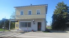
Stetten has a train station on the Buchloe – Memmingen line .
The town is connected to the federal motorway 96 via the Stetten motorway exit . In addition, federal road 18 and federal road 16 run not far from the town .
education
In 2018 there were two day-care centers with 67 places and 51 children.
Web links
- Entry on the coat of arms of Stetten (Swabia) in the database of the House of Bavarian History
- Stetten (Swabia): Official statistics of the LfStat (PDF file; 1 MB)
Individual evidence
- ↑ "Data 2" sheet, Statistical Report A1200C 202041 Population of the municipalities, districts and administrative districts 1st quarter 2020 (population based on the 2011 census) ( help ).
- ^ Community of Stetten in the local database of the Bavarian State Library Online . Bavarian State Library, accessed on August 15, 2019.
- ↑ a b c Federal Statistical Office (ed.): Historical municipality directory for the Federal Republic of Germany. Name, border and key number changes in municipalities, counties and administrative districts from May 27, 1970 to December 31, 1982 . W. Kohlhammer, Stuttgart / Mainz 1983, ISBN 3-17-003263-1 , p. 783 .
- ↑ Second votes, according to the source www.wahlen.bayern.de, accessed on March 4, 2018


