
Sea ice
As sea ice is known to ice , sometimes frozen seawater even the frozen water of the polar oceans . Seasonally, sea ice also occurs outside the polar regions, including in the Baltic Sea , in Scandinavian fjords, in the Gulf of Saint Lawrence and the Sea of Okhotsk . The sea ice is part of the cryosphere of our planet and covers an annual average of around 6.5 percent (equivalent to an area of 22.5 million km 2 ) of the world's oceans. The polar sea ice and the polar ice sheets of the mainland together form the polar ice . Sea ice plays due to the primarily through the ice-albedo feedback -induced polar gain a crucial role in the climate system of the earth .

Sea ice types


Sea ice shows a great wealth of different forms, which are largely determined by the swell. Frazil ice is initially formed on the moving ocean surface. These are fine ice needles or platelets up to 2 cm in size that condense into soup-like ice sludge . As it grows further, pancake ice forms, a layer of mostly circular pieces of ice up to 3 m in size with a bulging edge. Without a swell, new ice can arise in the form of a closed ice cover ( Nilas ). The ice cover becomes thicker mainly due to the freezing of water beneath the ice.
As a rule, the ice layer reaches a thickness of up to 2 m at the end of the freezing period and then forms annual ice . From a thickness of just under one meter, a sheet of sea ice insulates the water below it so that it does not freeze any further. Sea ice then increases in thickness mainly because ice floes are pushed together. This is especially true for the mostly perennial pack ice . Pushing the ice on top of one another can create meter-high press ice mounds in the pack ice. A lower proportion of perennial ice, as has been observed since the 1990s, is associated with greater seasonal fluctuations in sea ice cover.
Almost all of the sea ice in Antarctica is annual. It is located at a lower geographical latitude and largely melts in the summer when the water temperatures there are milder. In contrast, parts of the Arctic sea ice at higher geographical latitudes are perennial; they do not thaw completely in the arctic summer, but only when the ice drift transports them to lower latitudes.
Fixed ice is ice that is anchored on the coastline or on the sea floor, so it does not float freely on the sea surface. Pack ice is often not anchored to the mainland and can therefore be subject to ice drift . Drift ice consists of ice floes that have detached from an ice sheet.
A natural ice-free area that is completely surrounded by sea ice is called polynya . Artificial channels and holes made in the ice are called Wuhnen .
The ice shelf and icebergs formed by the glacier river are not counted as sea ice .
properties
The salt of the sea water (about 35 per thousand salinity) lowers its freezing point to approx. −1.9 ° C. When the ice grows, it is not built into the crystal lattice of the ice, but partly remains in the surrounding water, and partly it forms brine pockets in the ice. The salt content of the sea ice is only around three to five per thousand. (See also: Sea ice flower .)
If there is initially no convection, the formation of ice leads to an increase in salinity (the salt content) and thus also the density of the surrounding water. This can lead to the destabilization of the density stratification and to convection ( thermohaline circulation ). The thermohaline circulation is elementary for the formation of deep water and thus for the entire ocean circulation. The melting of the sea ice, however, acts like an entry of fresh water into the upper ocean layers, which stabilizes the stratification and counteracts convection.
The ice movement, driven by wind and ocean currents, is accompanied by a transport of fresh water and negative latent heat . Sea ice hinders the exchange of latent and sensible heat between the ocean and the atmosphere . Even a thin sheet of sea ice prevents the flow of heat almost completely. Where the ice cover is not completely closed, the heat output can reach several hundred watts per square meter.
The sea ice, which is mostly covered by snow, is characterized by a very high reflectivity ( albedo ) for sunlight. A large part of the short-wave radiation is absorbed by the ice-free ocean, whereas it is reflected by the sea ice . This self-reinforcing feedback, the ice-albedo feedback , has a major impact on the radiation balance of the polar regions and the earth as a whole.
Measurement

Remote sensing with satellite sensors in the microwave range is the only way to obtain global information about sea ice cover, and this almost independently of light and cloud cover. The sea ice has been measured from satellites using passive microwave sensors since 1979. One makes use of the property of the ice to emit different microwave radiation than sea water.
Using the satellite data, the sea ice area and sea ice extent are calculated, which are used to estimate the actual sea ice cover. To calculate the sea ice area , the portion of the ice area (the sea ice concentration ) is estimated for each area unit in the satellite data , usually 25 km 2 , and the entire sea ice area is calculated from this and the area unit. The extent of the sea ice , on the other hand, is the sum of the units of area in which the estimated proportion of sea ice exceeds a threshold value, usually 15%. Since surface changes, such as snow cover or meltwater puddles, make it difficult to estimate the exact sea ice concentration, the sea ice extent is the more consistent measure.
Other important measures are the sea ice thickness , which is determined by means of satellite missions such as ICESat or CryoSat -2, randomly from the surface or under the sea with sonar , and the sea ice volume , calculated from the sea ice concentration and thickness.
Ice floes are also measured directly to verify the satellite data. For this purpose, sensors dragged from the ship or by hand, ice drilling and a folding rule are used. An ice floe can be described in detail with just a few parameters (ice thickness, depth, freeboard, depth of the melt pool, thickness of the snow cover).
Sea ice in the Arctic
history

Geological data suggest that the history of Arctic sea ice is closely tied to climatic changes caused by changes in greenhouse gas concentrations, Earth's orbit, and the inclination of the Earth's axis. Large seasonal ice sheets formed in the Arctic after the Paleocene / Eocene temperature maximum about 47 million years ago. The first multi-year ice formed around 13-14 million years ago. With the beginning of the Quaternary period , about 3 million years (see also quaternary glaciation ), took to the ice cover, and it may in interglacials may have been seasonally ice-free periods. At the beginning of the Holocene , about 10,000 years ago, there was a phase of comparatively little ice cover. Since then, until the late 19th century, there have been no major changes affecting the entire Arctic.
present


The sea ice cover in the north fluctuates annually between around 15 million square kilometers in April and around 3.5 million square kilometers in September. Every summer around ⅔ to ¾ of the entire ice disappear. In winter this area then freezes over again, which represents a re-icing of around 10 million square kilometers. (This corresponds to about 28 times the area of the Federal Republic of Germany.) The ice front moves a few thousand km northwards during the summer melt and just as far southwards during the winter freezing - see adjacent figure.
The extent of sea ice in the Arctic has been declining since satellite measurements began. Declining trends are observed in all regions and all months, with the months with the greatest decline being September, July and August, the regions with the greatest annual mean decline being the Barents Sea and Kara Sea . The proportion of thick, perennial ice is also falling sharply. Since 1996, during the period of maximum sea ice extent, the proportion of one-year ice has predominated. The current ice loss appears to be extraordinary, at least when compared to the last several thousand years, and cannot be explained by the natural causes of past changes. In addition to wide-ranging oscillations such as the North Atlantic Oscillation , global warming is a cause. In September 2016, the sea ice cover in the Arctic (it usually increases rapidly in autumn) was a good million square kilometers smaller than the average for the years 1981 to 2010 at that time.
See also Consequences of Global Warming in the Arctic , Arctic Ice Cap .
Sea ice in the northern seas
For individual regions there are also observations that go back to before the satellite measurements. In the Barents Sea, the mean sea ice extent was observed in April, i.e. the month with maximum extent, over a period from 1850 to 2001 with the help of Norwegian ice maps and Soviet, Norwegian and American reconnaissance flights as well as satellite data from 1966. A continuous decline over this period was found.
In the northern European polar sea from 75 ° N, the ice has decreased by almost 30% on an annual average over the last 150 years. Ocean currents and sea surface temperature as well as atmospheric effects play a role in changes in ice extent. The North Atlantic Oscillation strongly determines the change in the extent of the ice. The European Arctic Ocean is often influenced by low pressure areas mostly moving northeastwards, while the Labrador Sea is more influenced by north winds.
For the years 1920–1998 there was a decrease in ice extent for the area given here of around 10% for April and around 40% for August. At the same time, the temperature on Svalbard rose by around 3 ° C in spring and around 1 ° C in winter. There has been an overall decline in sea ice of around 30% of its area since 1850. In the Barents Sea, sea ice almost completely disappears in summer.
At the beginning of the 20th century, the extent of the ice decreased, while the mean arctic winter temperature rose by 3 ° C and on Svalbard even around 9 ° C. From 1949 to the mid-1960s, the extent of sea ice in the Arctic Ocean increased temporarily, but has been decreasing again since the mid-1960s. The North Atlantic Current brings warm water masses towards the northeast. Overall, the sea surface temperature increased by about 1 ° C in the period ~ 1860-2000. The extent of the ice is largely dependent on the warming of the sea surface water. If atmospheric and oceanic effects occur simultaneously, this leads to an even greater decrease or increase in the extent of the ice. Since 1970, the former has been the case in connection with global warming.
Sea ice in Antarctica
History during the last glacial period
During the last glacial period (around 20,000 years ago) the sea ice in Antarctica was 70 to 100% more extensive than it is today. As a result, the oceanic circulation and temperature gradients in the southern ocean had a different shape.
Methods

Diatoms (diatoms) , radiolarians (radiation animals ) and planktonic foraminifera (chamberlings) are single-celled animals. The summer surface temperature and the extent of the winter and summer sea ice can be determined from the distribution of their sedimented silicon dioxide or calcareous deposits on the ocean floor. For this purpose, sediment cores from the ocean floor are evaluated, which enable a time series back to the maximum of the last ice age (23,000 to 19,000 years before today) and beyond. The age of individual sediment layers in the sediment drill cores is determined with the help of radiocarbon dating ( 14 C dating) and oxygen isotope ratios .
The sea surface temperature can be determined by determining the density of the now sedimented radiolarian and diatom silicon residues in the drill core. The extent of the sea ice is determined from the distribution of diatoms in various sediment cores in the meridional direction. Fewer diatoms live below the sea ice, so the diatom abundance is lower in sea ice-covered areas. Some species (e.g. Frgilariopsis obliquecostata ) only occur at very cold water temperatures (less than −1 ° C) and their occurrence marks the minimal extent of summer sea ice.
Compared to today

At the maximum of the last ice age , the extent of the winter sea ice in the Antarctic was 70 to 100% (about 39 · 10 6 km²) larger than it is today (19 · 10 6 km²). Likewise, the Antarctic circumpolar current was shifted by about 5-7 ° latitude to the north, so that it expanded into the present polar front zone. Among other things, this resulted in the summer surface temperature of the sea in the Antarctic zone being below 1 ° C in the Atlantic sector and below 2 ° C in the Indian and Pacific sectors. These values are around 3–4 ° C below the current values.
However, since the southern subtropical front in the ocean had only moved a little northward, this led to an increased thermal gradient in the southern ocean. As a result, zonal water transport was faster than it is today and atmospheric circulation patterns, such as westerly winds, were also shifted to the north.
Furthermore, the northward shift of the Antarctic circumpolar current led to a weakening of the cold water transport through the Drake Strait between South America and the Antarctic Peninsula into the Atlantic. Some of the cold water was diverted north on the west coast of South America. The import of warm, salty water from the Indian to the Atlantic Ocean south of Africa was not blocked, but weakened. Due to these two opposing effects of blocked cold water imports and little changed warm water imports into the southern Atlantic, the southern subtropical eddy was only slightly cooled compared to today. This resulted in a strong temperature gradient in the southern Atlantic between subtropics and southern polar regions.
Sea ice blocks the exchange of carbon dioxide between the atmosphere and the ocean. The increased winter sea ice surface, together with the colder surface water temperatures, could have played an important role in the decrease in atmospheric CO 2 concentration during the last ice age.
The summer extent of the sea ice during the last glacial maximum does not permit any reliable reconstructions. According to recent studies, it could occasionally have extended to the current winter sea ice extent in the Southern Ocean in the area south of the Atlantic and the western Indian Ocean. The low occurrence of the ice indicator diatoms ( Frgilariopsis obliquecostata ) would also allow a summer sea ice extent that is not significantly larger than the currently prevailing. There are indications that in the millennia before (about 29,000 to 23,000) the summer expansion was much greater. Overall, the difference in the extent of the summer sea ice (5 to 6 · 10 6 km²) compared to today (3 · 10 6 km²) is less than that of the winter sea ice extent. This suggests increased seasonality during the last ice age.
present
Like the Arctic sea ice, the Antarctic is also subject to seasonal fluctuations. It has its maximum extent in September, at the end of the Antarctic winter, its minimum in February. In contrast to the Arctic, the sea ice in Antarctica melts almost completely in summer because it is located at lower geographical latitudes. Accordingly, it mainly consists of annual ice.
In the period 1979 to 2006, i.e. since the beginning of satellite measurements, there has been a slightly increasing trend in the extent of sea ice for the Antarctic region as a whole. However, this is regionally and seasonally inconsistent. At present it is only decreasing in the area of the Amundsen and Bellingshausen Lakes, in other areas it is increasing, even if the increase is slowing down in some areas. In the area south of the Indian Ocean there was a trend reversal, from a decrease to an increase in ice cover.
The reasons for the different and sometimes increasing trends, despite increasing air and water temperatures, have not been finally clarified. For one, the depletion of the ozone layer over the Antarctic ( ozone hole ) could have increased circumpolar winds. This spreads the ice over a larger area and larger areas of open sea can freeze over. On the other hand, according to model calculations, the decreasing salinity of the southern ocean due to increased precipitation and meltwater input could be a cause.
See also Consequences of Global Warming in Antarctica
Comparison Arctic - Antarctic
The different geographic locations of the sea ice in the Arctic and Antarctic cause significant differences between the two regions. Arctic sea ice is located in an ocean that is half enclosed by continents and at significantly higher latitudes than the Antarctic sea ice, which surrounds the Antarctic continent and thus forms almost a geographical contrast. Antarctic sea ice moves more freely, with higher drift speeds and has a much higher variability because it is not surrounded by land masses. Almost all of the Antarctic sea ice has therefore always drifted into warmer latitudes and melted in the summer. While one-year, thin ice has long dominated the Antarctic sea ice, it has only been predominant in the Arctic in recent years due to the sharp decline in multi-year ice and has recently led to increased variability there.
While the ice surface has been declining in the Arctic over the past few years and decades, it has increased in the Antarctic. However, the decline in the amount of Arctic sea ice clearly outweighed the growth of Antarctic sea ice. The minimum sea ice extent in the Arctic decreased by 13.0% per decade (in absolute terms just under 3.5 million km² compared to the 1979–2010 average), while that in the Antarctic grew by 3.2% per decade (in absolute terms around 0 , 68 million km² compared to the average since 1979). In both polar regions there is a decrease in the average sea ice thickness and the sea ice volume , which in 2012 was, however, 72% below the average since 1979 in the Arctic, much more pronounced than in the Antarctic. The latter even recorded a slight increase in ice volume for the summer months, which, however, with an annual increase of 160 km³, accounts for less than a hundredth of the volume loss in the Arctic.
In 2009, John Turner of the British Antarctic Survey said that the reason for the increasing ice surface in Antarctica was to be found in the ozone hole , which has cooled it there in recent years. He expects this effect to last for a maximum of a decade and then a decrease in the amount of ice will also be observable there. In addition, the effect of the ozone hole increased Antarctic storm eddies, which warmed the Antarctic peninsula but allowed the Ross Sea to cool. In the Arctic Peninsula, therefore, ice cover decreased while it increased in the Ross Sea . Several studies support the influence of altered winds on sea ice formation in Antarctica; these resulted in the ice being distributed over a larger area, but also diverted heat flows.
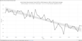
Development of the extent of the Arctic sea ice over the past 40 years

Arctic sea ice cover compared to the simulated course as it is shown in common climate models. The actual melting rate significantly exceeds the modeled melting rate.

Development of the extent of the Antarctic sea ice over the past 40 years


ecology

The sea ice, hostile to life at first glance, is the habitat for numerous, especially small, plant and animal species, with plankton forms dominating. Species that live in or connected to the ice are referred to as sympathetic . Both autochthonous species, i.e. species that only occur there, and species that only live there temporarily, occur in the sea ice . The sea ice offers habitats on the ice, there in press ice ridges, the snow cover or meltwater puddles, also in its interior, in brine channels, and on its bottom, where algae that settle there are food for krill . Many animals in the Arctic fauna, such as crabs, fish, whales and seals, depend directly or indirectly on krill in the food chain. Polynjas, where seals emerge to breathe, are an important hunting ground for polar bears .
See also
literature
- World Meteorological Organization (Ed.): WMO Sea-Ice Nomenclature: Terminology, Codes and Illustrated Glossary . 1970. See also the NOAA Sea Ice Glossary (en.).
- Petra Demmler: The sea - water, ice and climate . Ulmer, 2011. , Chapter "Ice on the Sea", with a popular science presentation
- Gerland et al .: Global Outlook for Ice and Snow, Chapter 5: Ice in the Sea . Ed .: United Nations Environment Program. 2007 ( unep.org [PDF; 3.0 MB ]).
Web links
- to the knowledge platform meereisportal.de
- Daily updated maps of the sea ice extent
- Links to sea ice satellite maps
- ICEMON project
- Sea ice on sea ice and climate change in the educational wiki klimawiki.org
Individual evidence
- ↑ a b Stroeve et al .: The Arctic's rapidly shrinking sea ice cover: a research synthesis . In: Climatic Change . 2012, p. 1005-1027 , doi : 10.1007 / s10584-011-0101-1 ( PDF ). PDF ( Memento of the original from February 1, 2012 in the Internet Archive ) Info: The archive link was automatically inserted and not yet checked. Please check the original and archive link according to the instructions and then remove this notice.
- ^ Sea Ice. Monitoring Sea Ice. NASA Earth Observatory System, accessed March 3, 2012 .
- ↑ a b Polyak et al .: History of sea ice in the Arctic . In: Quaternary Science Reviews . 2010, p. 1757-1778 .
- ↑ Fetterer, F., K. Knowles, W. Meier, and M. Savoie. 2002, updated 2009. Sea Ice Index. Boulder, Colorado USA: National Snow and Ice Data Center. Digital media.
- ↑ Jinlun Zhang and DA Rothrock: Modeling global sea ice with a thickness and enthalpy distribution model in generalized curvilinear coordinates . In: Monthly Weather Review . tape 131 , no. 5 , 2003, p. 681-697 , doi : 10.1175 / 1520-0493 (2003) 131 <0845: MGSIWA> 2.0.CO; 2 .
- ↑ a b Parkinson and Cavalieri: Arctic sea ice variability and trends, 1979-2006 . In: Journal of Geophysical Research . 2008, doi : 10.1029 / 2007JC004558 .
- ↑ spiegel.de: Global sea ice is shrinking dramatically
- ^ Shapiro, I. et al .: April sea ice extent in the Barents Sea, 1850-2001 . In: Polar Research . tape 55 , 2003, p. 5-10 .
- ↑ T. Vinje: Anomalies and Trends of Sea-Ice Extent and Atmospheric Circulation in the Nordic Seas during the Period, 1864-1998 . American Meteorological Society, 2001, p. 258 .
- ↑ T. Vinje: Anomalies and Trends of Sea-Ice Extent and Atmospheric Circulation in the Nordic Seas during the Period, 1864-1998 . American Meteorological Society, 2001, p. 264-265 .
- ^ Gersonde et al .: Sea-surface temperature and sea ice distribution of the southern Ocean at the EPILOG Last Glacial Maximum - a circum-Antarctic view based on siliceous microfossil records . In: Quaternary Science Reviews . tape 24 , 2005, pp. 869-896 , doi : 10.1016 / j.quascirev.2004.07.015 . , here pp. 869-871 and 885
- ↑ Gersonde et al .: Last glacial sea surface temperatures and sea-ice extent in the Southern Ocean (Atlantic-Indian sector): A multiproxy approach . In: Paleoceanography . tape 18 , no. 3 , 2003, p. 1061 , doi : 10.1029 / 2002PA000809 . , here: pp. 1061-1065
- ^ Gersonde et al .: Sea-surface temperature and sea ice distribution of the southern Ocean at the EPILOG Last Glacial Maximum - a circum-Antarctic view based on siliceous microfossil records . In: Quaternary Science Reviews . tape 24 , 2005, pp. 869-896 , doi : 10.1016 / j.quascirev.2004.07.015 . , here pp. 885-886,894
- ↑ a b Gersonde et al .: Sea-surface temperature and sea ice distribution of the southern Ocean at the EPILOG Last Glacial Maximum - a circum-Antarctic view based on siliceous microfossil records . In: Quaternary Science Reviews . tape 24 , 2005, pp. 869-896 , doi : 10.1016 / j.quascirev.2004.07.015 . , here p. 893
- ↑ Gersonde et al .: Last glacial sea surface temperatures and sea-ice extent in the Southern Ocean (Atlantic-Indian sector): A multiproxy approach . In: Paleoceanography . tape 18 , no. 3 , 2003, p. 1061 , doi : 10.1029 / 2002PA000809 . , here: Paragraph 29
- ↑ Gersonde et al .: Last glacial sea surface temperatures and sea-ice extent in the Southern Ocean (Atlantic-Indian sector): A multiproxy approach . In: Paleoceanography . tape 18 , no. 3 , 2003, p. 1061 , doi : 10.1029 / 2002PA000809 . , here: para. 21,32
- ^ Gersonde et al .: Sea-surface temperature and sea ice distribution of the southern Ocean at the EPILOG Last Glacial Maximum - a circum-Antarctic view based on siliceous microfossil records . In: Quaternary Science Reviews . tape 24 , 2005, pp. 869-896 , doi : 10.1016 / j.quascirev.2004.07.015 . , here p. 891
- ^ DJ Cavalieri and CL Parkinson: Antarctic sea ice variability and trends, 1979-2006 . In: Journal of Geophysical Research . tape 113 , 2008, doi : 10.1029 / 2007JC004564 .
- ↑ Turner et al .: Non-annular atmospheric circulation change induced by stratospheric ozone depletion and its role in the recent increase of Antarctic sea ice extent . In: Geophysical Research Letters . 2009, doi : 10.1029 / 2009GL037524 .
- ^ Zhang: Increasing Antarctic sea ice under warming atmospheric and oceanic conditions . In: J. Clim. 2007.
- ↑ All about sea ice: Arctic vs. Antarctic. National Snow & Ice data center, accessed December 30, 2012 .
- ^ Opposite Behaviors? Arctic Sea Ice Shrinks, Antarctic Grows. National Snow & Ice data center, October 23, 2012; accessed December 30, 2012 .
- ↑ Arctic Sea Ice Volume Anomaly, version 2. Polar Science Center, accessed December 31, 2012 .
- ^ NT Kurtz, T. Markus: Satellite observations of Antarctic sea ice thickness and volume . In: Journal of Geophysical Research . tape 117 , 2012, doi : 10.1029 / 2012JC008141 .
- ↑ Why Antarctic ice is growing despite global warming. New Scientist, April 20, 2009, accessed January 1, 2013 .
- ^ Poles apart: A record-breaking summer and winter. National Snow & Ice data center, October 2, 2012; accessed December 30, 2012 .
- ^ Paul R. Holland, Ron Kwok: Wind-driven trends in Antarctic sea-ice drift . In: Nature Geoscience . November 2012, doi : 10.1038 / ngeo1627 .
- ^ Antarctic sea ice variability and trends, 1979–2010. (PDF; 5.9 MB) Cryospheric Sciences Laboratory / Code 615, NASA Goddard Space Flight Center, Greenbelt, MD 20771, USA, May 16, 2012, accessed on January 20, 2013 .
- ^ Rita Horner et al .: Ecology of sea ice biota . In: Polar Biology . No. 12 , 1992, pp. 417-427 .
- ↑ Nadja Podbregar: scinexx Dossier: Habitat Sea Ice - Survivor in the smallest of spaces. Retrieved April 3, 2012 .