
Motael
| Motael | |||

|
|||

|
|||
| Data | |||
| surface | 0.77 km² | ||
| population | 5,039 (2015) | ||
| Chefe de Suco | Cornelio de Aráujo Lopes (election 2009) |
||
| Aldeias | Population (2015) | ||
| Bee Dalan | 2.010 | ||
| Boa Morena | 1,308 | ||
| Halibur | 1,146 | ||
| Hura | 481 | ||
| Lirio | 94 | ||
|
|||

Motael (formerly 20 Maio ) is an East Timorese Suco , which forms a district of the state capital Dili . Motael has been part of the Vera Cruz Administration Office since 2004, and before that to Dom Aleixo .
geography
| Motael | ||
| places | position | height |
| Aitarak | 8 ° 33 ' S , 125 ° 34' E | 0 m |
| Bairo Alto | 8 ° 33 ' S , 125 ° 34' E | 8 m |
| Bebora | 8 ° 33 ' S , 125 ° 34' E | 0 m |
| Farol | 8 ° 33 ' S , 125 ° 34' E | 0 m |
| Palapaso | 8 ° 33 ' S , 125 ° 34' E | 0 m |
The Suco belongs to the center of the capital. At the point where the Bay of Dili pushes into the land again, Motael is at the western end of the small bay. To the south are the Sucos Colmera and Vila Verde and to the west are the Sucos Bairro Pite and Kampung Alor , which belong to the administrative office of Dom Aleixo. The western border is followed by the Maloa River in the rainy season . Before the 2015 territorial reform, Motael had an area of 0.55 km². Now it is 0.77 km². Motael received from Colmera and Vila Verde the area between Avenida Nicolau Lobato in the north, the Maloa River in the west, Rua da Catedral in the east and Avenida Dom Ricardo da Silva. In addition, the strip of land from Colmera between the bay and Avenida Marginal went to Motael, so that Motael now extends in the east to the Suco Bidau Lecidere (administrative office of Nain Feto ).
Motael is divided into at least five districts: Aitarak in the northwest, Palapaso in the northeast, Bebora in the southwest and Farol in the southeast. To the south, Bairo Alto was added in 2015 and to the south-west, Vila Verde , which is actually the namesake of the neighboring sucos. Farol ( Portuguese for lighthouse ) was the residential area of the European population of Dilis at the end of the colonial period. The section, which was added to Motael in 2015, consists of the west of the Bairo Alto district and the north of Vila Verde and Mata Doro .
In the Suco there are the five Aldeias Bee Dalan , Boa Morena , Halibur , Hura and Lirio .
Residents
The Suco has 5039 inhabitants (2015), of which 2567 are men and 2472 women. The population density is 6537.3 inhabitants / km². There are 773 households in the Suco. Almost 92% of the population name Tetum Prasa as their mother tongue. Minorities speak Resuk , Rahesuk , Makasae , Makalero , Idaté , Fataluku or Tetum Terik . The place name "Motaél" comes from the Mambai and means "estuary". It is evidence that Mambai was originally spoken instead of Tetum in the Dili region .
history


.jpg&filetimestamp=20131104120143&)
The district got its name from the Timorese Empire, which ruled over the region when the Portuguese moved the capital of their colony here in 1769. Jesuits had already successfully converted children to Christianity here and left Christianized soldiers from Larantuka to the Liurai of Motael to protect them from Muslim attacks. As a loyal ally, Dom Alexandre , the Liurai of Motael, provided the Portuguese with the land and timber they needed to found Dilis. He also assured them men and horses for defense. Over time, Motael became a powerful force within the Portuguese Timor colony .
From 1810 to 1812, Motael's Liurai was one of the leading members of the Conselho Governativo , who ruled the colony instead of the missing governor. In 1867 Motael helped the Portuguese put down the Vemasse rebellion. In 1887, as one of those responsible for the revolt of the Moradores , the Liurai of Motael, Lucas Martins , was arrested and finally brought to justice in Goa . In the course of the revolt, the governor Alfredo de Lacerda Maia was murdered.
The ruler's house stood in what is now Motael's district, near today's port . To the southeast was the governor's seat of government, where Jardim 5 de Maio is today .
During the civil war in East Timor in 1975 , both parties occupied the port. The Portuguese administration left the colonial capital from here towards the offshore island of Atauro . On December 7th of the same year, Indonesian troops landed in Dili. After conquering the city , the Indonesians led Chinese , members of FRETILIN and other prisoners to the port area, shot them and threw the bodies into the sea. The victims included suffragette Rosa Bonaparte , her brother Bernardino Bonaparte Soares , Isabel Lobato (the wife of Prime Minister Nicolau dos Reis Lobato ) and Roger East , the last foreign reporter in Dili. Witnesses speak of dozens of bodies. The total number of those executed in the shipyard is estimated at 150 people.
On October 27, 1991, East Timorese Sebastião Gomes was shot by Indonesian security forces and bled to death in the Church of Santo António de Motael . At his funeral there was a demonstration for the independence of East Timor. The result was a massacre of the demonstrators by Indonesian security forces, the so-called Santa Cruz massacre .
In 2006 a camp was set up at Motael Church to provide shelter for refugees after the 2006 riots in East Timor .
politics

In the elections of 2004/2005 was Cornelio de Araujo Lopes elected Chefe de Suco and in 2009 re-elected.
Buildings and facilities
.jpg)
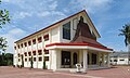
There are several buildings worth seeing in Suco Motael. The Church of Santo António de Motael (also Church of Motael ) in the Portuguese style is the oldest existing church in East Timor, even if the building had to be rebuilt in 1955 after the Battle of Timor in World War II . A large church building, the Igreja Hosana of the Protestant Church in East Timor ( Igreja Protestante iha Timor Lorosa'e ), was inaugurated in October 2014 on Avenida D. Ricardo da Silva by Xanana Gusmão . The Jardim 5 de Maio ( May 5th Garden ) with the integration monument is located at the southeastern tip of the Sucos . Between the park and the church stands the Messe para Funcionários Solteiros building, which was built in 1953 and is a former dormitory for single colonial officials with a hipped roof covered with red tiles .
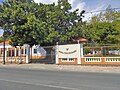
In the center of Motael is the primary school ( Escola Primaria Farol ), on the northeast bank a station of the National Police of East Timor and on the north bank the Motaels lighthouse; Not in Farol, as one might expect from the name, but in Palapso. Opposite, in a colonial villa that was renovated in 2003 with Korean help, is the Ministry of Tourism to the west, the Autoridade Nacional do Petróleo e Minerais (ANPM) and to the east, the Thai embassy. The coast on the Bay of Dili is occupied by the port of Dili, the most important in the country. It is to be replaced by a new port in the Bay of Tibar , which is currently under construction.
Opposite the Church of Santo António is the Jardim Motael (Jardim 12 de Novembro) with the memorial for the Santa Cruz massacre (also Estátua da Juventude ). In the north, south of the Ministry of Tourism, on Rua dos Direitos Humanos, the Jardim Borja and between the Avenida de Portugal and the Travessa Sérgio Vieira de Mello to the south, near the Motael lighthouse, the Jardim Farol , which is used for traditional religious ceremonies becomes. Jardim Infantil is located in Bebora between Avenida Nicolau Lobato and Rua Dom Boaventura . On the south side of Rua Dom Boaventura are the headquarters of the Timor Post , the TV station GMN TV and the Ministry of Economic Affairs in the Mandarim building.
The court of the municipality of Dili is located on the west side of the Rua da Catedral, which now belongs to Motael. The headquarters of USAID and the Comissão Anti-Corrupção (CAC) are located in Farol .

Santo António Church in Motael

Ministry of Tourism

Ministry of Economy and Development
Igreja Hosana

Promenade in front of the government palace

Memorial to the Santa Cruz Massacre
Embassy of Thailand

Direção de Minerais of the ANPM
.jpg)


.jpg)


.jpg&filetimestamp=20131104120143)
See also
Web links
- Results of the 2010 census for the Suco Motael ( tetum ; PDF; 8.1 MB)
- Results of the 2015 census for the Suco Motael (tetum; PDF)
- Seeds of Life: Suco information sheets Vera Cruz (tetum)
Individual evidence
- ↑ a b c d Direcção-Geral de Estatística : Results of the 2015 census , accessed on November 23, 2016.
- ↑ Timor-Leste: Poverty in a Young Nation ( Memento from December 25, 2010 in the Internet Archive ) (PDF; 1.2 MB)
- ↑ Fallingrain.com: Directory of Cities, Towns, and Regions in East Timor
- ^ Timor-Leste GIS-Portal ( Memento from June 30, 2007 in the Internet Archive )
- ↑ Direcção Nacional de Estatística: Population Distribution by Administrative Areas Volume 2 English ( Memento from January 5, 2017 in the Internet Archive ) (Census 2010; PDF; 22.6 MB)
- ↑ a b Ministry of State Administration and Territorial Management : Map of the Vera Cruz Administrative Office ( memento of January 10, 2017 in the Internet Archive ), accessed on April 1, 2017.
- ↑ a b UNMIT: Timor-Leste District Atlas version 02, August 2008 ( Memento from December 3, 2011 in the Internet Archive ) (PDF; 448 kB)
- ↑ Jornal da Républica with the Diploma Ministerial n. 199/09 ( Memento of February 3, 2010 in the Internet Archive ) (Portuguese; PDF; 323 kB)
- ↑ Results of the 2010 census for the Suco Motael ( tetum ; PDF; 8.1 MB)
- ↑ Geoffrey Hull : The placenames of East Timor , in: Placenames Australia (ANPS): Newsletter of the Australian National Placenames Survey, June 2006, pp. 6 & 7, ( Memento of the original from February 14, 2017 in the Internet Archive ) Info: The archive link was inserted automatically and has not yet been checked. Please check the original and archive link according to the instructions and then remove this notice. accessed on September 28, 2014.
- ↑ Architectural Heritage of Portuguese Origin , map on p. 16 , accessed June 3, 2016.
- ↑ "Part 3: The History of the Conflict" (PDF; 1.4 MB) from the "Chega!" Report of the CAVR (English)
- ↑ “Chega!”: “Chapter 7.2 Unlawful Killings and Enforced Disappearances”, Dili wharf on December 8, 1975 , pp. 40-43.
- ↑ ABC: Australia received East Timor 'hit list' before Indonesian invasion , November 27, 2015 , accessed December 19, 2016.
- ↑ ABC News: East Timor's latest attempt to find the body of its first prime minister Nicolau dos Reis Lobato , February 21, 2018 , accessed February 21, 2018.
- ^ Frédéric Durand: Three centuries of violence and struggle in East Timor (1726–2008) , 2011.
- ↑ Peter Carey: East Timor under Indonesian Occupation, 1975-99 , pp. 14ff., Accessed on December 6, 2018.
- ↑ Secretariado Técnico de Administração Eleitoral STAE: Eleições para Liderança Comunitária 2004/2005 - Resultados ( Memento of August 4, 2010 in the Internet Archive )
- ↑ Secretariado Técnico de Administração Eleitoral STAE: Eleições para Liderança Comunitária 2009 - Resultados ( Memento of August 4, 2010 in the Internet Archive )
- ↑ Tony Wheeler, Xanana Gusmao, Kristy Sword-Gusmao: East Timor. Lonely Planet, London 2004, ISBN 1-74059-644-7
- ↑ Memorial plaque in front of the building (Portuguese).
- ↑ Timor Tourism: Statue of Integration ( Memento of the original from November 24, 2015 in the Internet Archive ) Info: The archive link has been inserted automatically and has not yet been checked. Please check the original and archive link according to the instructions and then remove this notice. , accessed November 24, 2015.
- ↑ Património de Influência Portuguesa: Messe para Funcionários Solteiros , accessed on December 18, 2016.
- ↑ List of polling stations for the parliamentary elections in East Timor 2007 (PDF; 118 kB)
- ↑ Memorial plaque on the building (in Portuguese and English)
Caicoli | Colmera | Dare | Lahane Ocidental | Mascarenhas | Motael | Vila Verde