
Torres del Paine National Park
| Torres del Paine National Park | |||
|---|---|---|---|
 |
|||
|
|||
| Location: | Magallanes and Chilean Antarctica , Chile | ||
| Next city: | Puerto Natales | ||
| Surface: | 2420 km² | ||
| Founding: | 1959 Chile, 1978 UNESCO | ||
.jpg) |
|||
 |
|||
 |
|||

The Torres del Paine National Park ( Spanish Parque Nacional Torres del Paine ) is one of the most famous national parks in Chile , located in the south of the country around the mountain range of the Cordillera del Paine . Paine means "sky blue" in the language of the Tehuelche Indians (Aonikenk Indians, Patagonians ), Torres del Paine means "towers of the blue sky".
Geography and climate
The Torres del Paine National Park is located in southern Chile and is part of Patagonia . It belongs to the Región de Magallanes y de la Antártica Chilena ( Province Última Esperanza ) and is located around 140 km north of the city of Puerto Natales .
In the north the national park borders on Argentina , where the Los Glaciares National Park adjoins. In the west is the Gray Glacier with the lake Lago Gray , in the south the Lago del Toro and in the east the Lago Sarmiento de Gamboa .
The national park area covers 2420 km². It is criss-crossed by almost 3000 m high mountains, glaciers , fjords and large lakes.
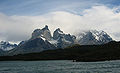
The "Torres del Paine" are the symbol of the national park. These are three needle-like granite mountains that are between 2600 and 2850 m high. The mountains are roughly in the middle of the national park. To the south of these three mountains lies Lago Nordenskjöld , named after the Swedish geologist Otto Nordenskjöld .
The highest mountain in the national park is Cerro Paine Grande at 3050 m.
Large parts of the national park are glaciated. The most famous glacier is the Gray Glacier , which calves into Lago Gray .
In summer the mean temperatures are around 11 ° C and in winter around 1 ° C.
history
The last ice age in Patagonia ended around 14,000 years ago , and the glaciers have been retreating since then. So many animals settled in the area. In 1895 the German adventurer and settler Hermann Eberhard found a remnant of fur from Mylodon , a giant sloth from the Ice Age . The Cueva del Milodón east of the park is a popular tourist destination.
In 1906 the town of Cerro Castillo was built on the eastern edge of the park.
Before the park was set up by the government of Chile, the landowners had already burned large parts of the forests in order to gain grazing land for sheep. Today the landscape is left to nature again.
The national park was established on May 13, 1959 and is administered by the Chilean forest authority CONAF . In 1978 he became the biosphere reserve of UNESCO explained.
On February 17, 2005, a devastating forest fire broke out in the park. More than 15,000 hectares of forest were destroyed. Another fire in late December 2011 / early 2012 destroyed over 14,000 hectares of forest. Both fires were caused by careless tourists.
Flora and fauna

The landscape is varied. There are large glaciated areas, high mountains, many lakes, “ Magellanic tundra ” and large forests of cypress , lenga and olivillo trees, as well as many types of flowers, including orchids .
The wildlife in the park is diverse. The guanacos , Darwin's rheas , Andean condors and many smaller bird species are striking .
tourism
The national park is well developed. The main administration is in the area of Lago Toro . The park is z. B. from October to April by buses from Puerto Natales . Shuttle buses run from the entrance at Laguna Amarga to the Base de las Torres (beginning of the hiking trail) and to the catamaran pier.
There are several smaller administrative points within the park. The CONAF has created many hiking trails. There are also several camping and hut areas, which are operated by the tourism organizations Vertice and Fantastico Sur in addition to CONAF. Almost the entire eastern part of the park from Camp Frances to Refugio Central is privately owned and operated exclusively by Fantastico Sur. All three organizations operate reservation systems for their campsites and refugios independently of one another, which considerably complicates the planning of a multi-day hiking tour. In the park itself, strict environmental regulations apply in order not to unnecessarily pollute nature. These are shown in a mandatory short video when entering the park.
The entry price for adults in 2018 is CLP 21,000, which can only be paid in cash. Prices for one night in a tent with compulsory meals can be up to 80 EUR per person.
Visitors to the varied landscape include trekking enthusiasts, mountaineers, glacier tourists as well as animal and plant lovers.
There are two major hiking trails in the national park: the W-Trekking (starting point Puerto Natales; approx. 100 km) and the O-Trekking / Torres del Paine Circuit (starting point Puerto Natales; approx. 130 km).
economy
The park is a major economic factor for the relatively deserted area in the north of the Magallanes region.
A trunk road connects Puerto Natales and the national park. The driving distance is only 80 km instead of 140 km as before.

Lago Nordenskjöld
Cuernos del Paine

Rapids of the Rio Paine

Horsemen in the Torres del Paine NP

Guanacos at the Laguna Amarga

Darwin's rhea at Posada Rio Serrano

View at the beginning of the national park


See also
Individual evidence
- ↑ Ministro de Agricultura asegura que daños en Torres del Paine es menor de lo pronosticado. January 1, 2012, accessed April 11, 2020 (Spanish).
- ↑ Vertice
- ↑ Refugios y Programas | Torres del Paine | Fantástico Sur | Patagonia Chile. Retrieved April 11, 2020 (American English).
- ↑ Hiking trails in the Torres del Paine National Park. Retrieved November 12, 2017 .
Web links
Alberto de Agostini | Alerce Andino | Alerce Costero | Bernardo O'Higgins | Bosque de Fray Jorge | Chiloe | Conguillío | Corcovado | Hornopirén | Huerquehue | Isla Guamblin | Isla Magdalena | Juan Fernández Archipelago | Cape Horn | La Campana | Laguna del Laja | Laguna San Rafael | Las Palmas de Cocalán | Lauca | Llanos de Challe | Llullaillaco | Morro Moreno | Nahuelbuta | Nevado Tres Cruces | Pali Aike | Pan de Azúcar | Puyehue | Queulat | Radal Siete Tazas | Rapa Nui | Salar del Huasco | Tolhuaca | Torres del Paine | Vicente Pérez Rosales | Villarrica | Volcán Isluga