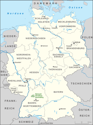
Stromberg-Heuchelberg Nature Park
|
Stromberg-Heuchelberg Nature Park
|
|
| location | Baden-Wuerttemberg , Germany |
| Area / extent | 328.21 km² / 32.5 km |
| Geographical location | 49 ° 4 ' N , 8 ° 55' E |
| Setup date | 1986 |
The Stromberg-Heuchelberg Nature Park is 328.2 km² and part of the districts of Ludwigsburg , Heilbronn , Karlsruhe and Enzkreis , with the Ludwigsburg district having the largest share. The nature park is characterized by the two mountain ranges Stromberg and Heuchelberg . Geologically, the nature park belongs to the Keuperbergland . The southern slopes of the Stromberg are suitable for viticulture. Numerous hiking trails lead through the nature park. Much of the area is forested.
At the request of the city of Bretten, an approximately 20-hectare wooded area in the Bretten district was removed from the nature park, the area was cut down and is now available as an extension of the Gölshausen industrial park. In 2004, 6,000 signatures were collected against this project by the "Initiative Rüdtwald", which is committed to the preservation of the particularly ecologically valuable mixed forest there.
In May 2009 the new nature park center was opened at the Zaberfeld reservoir Ehmetsklinge , which serves as a central contact point for visitors. It houses the office and an interactive exhibition. Under the motto “Wine. Forest. The exhibition provides information about the various facets of the region and the sights in the nature park.
Hohenhaslach am Stromberg
Wolfsstein in the Stromberg
See also
Web links
- Stromberg-Heuchelberg Nature Park
- Profile of the nature park in the LUBW's list of protected areas
- Map of the Stromberg-Heuchelberg Nature Park to: State Institute for the Environment Baden-Württemberg (LUBW) ( Notes )


