Niers
| Niers | ||
|
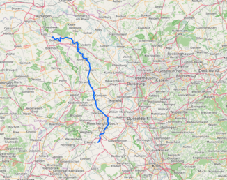
Course of the Niers |
||
| Data | ||
| Water code | EN : 286 | |
| location |
Germany
|
|
| River system | Rhine | |
| Drain over | Meuse → North Sea | |
| River basin district | Meuse | |
| source | in the Jülich Börde near Kuckum 51 ° 4 ′ 49 ″ N , 6 ° 23 ′ 31 ″ E |
|
| Source height | approx. 73 m above sea level NN | |
| muzzle | to Gennep in the Maas Coordinates: 51 ° 42 ′ 51 ″ N , 5 ° 56 ′ 51 ″ E 51 ° 42 ′ 51 ″ N , 5 ° 56 ′ 51 ″ E |
|
| Mouth height | approx. 9 m above sea level NN | |
| Height difference | approx. 64 m | |
| Bottom slope | approx. 0.57 ‰ | |
| length | 113.1 km; with the longest source stream (Wockerrather Fließ) : 117.6 km |
|
| Catchment area | 1,380.63 km² | |
| Discharge at the Goch gauge (without Kendel) A Eo : 1.203 km² |
NNQ MNQ 1950–2017 MQ 1950–2017 Mq 1950–2017 MHQ 1950–2017 HHQ |
1.145 m³ / s 3.331 m³ / s 7.77 m³ / s 6.458.9 m³ / (s km²) 21.96 m³ / s 42.383 m³ / s |
| Residents in the catchment area | 735,000 | |
|
The Niers near Weeze |
||

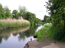
The Niers is an eastern and right tributary of the Meuse in Germany and the Netherlands . Without the Wockerrather Fließ or Kaulhauser Fließ (4.5 km) on the left-hand side , it is 113.1 km long, 8 km of which flow through the Netherlands; with the source brook there is a total of 117.6 km of flowing distance.
The river runs in the left part of the Lower Rhine region west of the watershed between the rivers Rhine and its tributary Maas. It has its source in Kuckum and flows through Geldern and Goch (all in North Rhine-Westphalia ; Germany) to flow into the Meuse after Gennep ( Limburg province ; Netherlands). The catchment area covers 1,380.63 square kilometers and is inhabited by 735,000 people.
geography
course
Headwaters
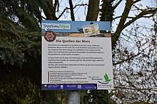
The headwaters of the Niers are located in the Jülich Börde in the east of the town of Erkelenz in the Heinsberg district - in the Kuckum district . The river used to have several sources , the main sources being at the Zourshof in Kuckum and at the “Klocken Sprung” in Keyenberg . The Niers is also fed by various small watercourses (drainage ditches), such as the Köhm from the Borschemich district of Erkelenz , which flows into the Niers in Keyenberg. Water also flowed into the Köhm from the Keyenberg trench system, which in turn was fed by springs.
The sources have dried up today due to the Garzweiler open-cast lignite mine . So that the natural water flow does not decrease further, the Niers on the upper reaches, for example near Zourshof, is supplied with marsh water from the opencast mine via pipes. In addition, the Niers receives an inflow from the Wockerather Fließ, which is fed by the Kückhover Fließ and flows from the direction of the Erkelenz core city. The 113.1 km long Niers kilometer begins north of the Zourshof.
Upper course
Initially, the Niers flows through between Kuckum and Unterwestrich , which also belongs to Erkelenz . Then it runs in the urban area of Mönchengladbach through the following districts and locations or past them: Wanlo , Wickrathberg , Wickrath , after crossing under the federal motorway 61 Wetschewell , Odenkirchen , Geistenbeck , Mülfort , Rheydt-Mitte and between Geneicken and Tackhütte past the Geneicken flood retention basin . Then it flows between the Mönchengladbach districts of Pesch and Neuwerk in the west and the core of the town of Korschenbroich in the Rhine district of Neuss and its district of Herrenshoff in the east - until there, mostly northeast.
Middle course
Then the Niers swings to the northwest when crossing under the federal highway 44 in quick succession at the trotting track Mönchengladbach , shortly afterwards to cross under the federal highway 52 once and then only southwest past Neersen , a district of the town of Willich in the district of Viersen , and then past northeast to flow to the Viersen districts of Robend , Hülsdonk , Rahser , Sittard , Süchteln and Vorst ; at Süchteln the river swings to the north-northwest. It then runs in the Grefrath municipality past Oedt and Mülhausen in the east and Grefrather Kernort and Vinkrath in the west.
Lower course
Then the Niers reaches the Kleve district , where it crosses under the federal motorway 40 , flows north through the municipal area of Wachtendonk and runs east past the core town of Straelen . After passing Pont to the east in the area of the city of Geldern , it flows through the center of Geldern and past Veert to the east . According to this, the Niers runs in the urban area of Kevelaer approximately northeast past Wetten , where it swings to the northeast, and then between the Kevelaer core city in the southwest and the Schravelen district in the northeast. Then it flows in the municipal area of Weeze past the Schloss Wissen and after an elongated Niersaltarm immediately east past the Weezer core town. After crossing under the federal autobahn 57, the Niers flows through the urban area of Goch , where it gradually swings to the west, crosses the core city and passes the districts of Pfalzdorf in the west, Nierswalde in the south and Asperden and Kessel in the north.
muzzle
Then the Niers reaches the Dutch border, where it bends to the south and runs a piece on the same, and shortly afterwards before the Gocher district of Hommersum finally bends to about west-northwest. In the Dutch province of Limburg , which is then reached , it flows between the core town of Gennep and the Ottersum district of Gennep, only to flow into the Maas, which flows there from about the south-southeast .
Tributaries and canals
(from the source to the mouth): on the upper reaches up to and including Mönchengladbach: Köhm , Hochneukircher Fließ, Karotte, Beller Bach, Gladbach and Trietbach.
A little north of the Mönchengladbach-Neuwerk sewage treatment plant and southwest of Willich-Neersen , the Cloer, coming from the Schiefbahn , flows from the right . It has a length of about 6.7 km, its catchment area is about 10.22 square kilometers and essentially extends over the southern areas of the Willich districts of Schiefbahn and Neersen .
Between Viersen on the one hand and Willich- Anrath or -Neersen on the other hand, the Hammer Bach coming from the Viersen urban area flows from the west . The catchment area of the Hammer Bach is around 13.75 square kilometers and extends to the city limits of Mönchengladbach. The Dorfer Bach , as the "Viers" namesake of the city, now only flows east of the city area on the surface and (united with the Alsbach) also flows from the west at Clörath into the Niers.
Slightly southwest of Oedt (Grefrath) opens from the right to herein as a branch channel called Kanal III3b , not least by its own main tributaries, the channel III C and the Willicher Flöth , an extensive area of over 80 square kilometers of drains that goes down to the Krefeld The outskirts are enough.
Behind Wachtendonk , the Nette flows into the Niers. It has a length of 28 kilometers, runs through the Krickenbeck lakes and has a catchment area of around 180 square kilometers.
The Niers Canal branches off in Geldern and runs across the German-Dutch border and ends in the Maas north of Arcen en Velden (serves as a flood relief for the Lower Niers, built around 1777?). The Niers Canal partially uses the former bed of the Fossa Eugeniana . Also in Geldern, the Geldern Fleuth , named after the place , which has a length of about 27 kilometers and a catchment area of 170 square kilometers, flows into the Niers. The Issumer Fleuth with a length of 25 kilometers and a catchment area of around 120 square kilometers flows into the Niers at Kevelaer . The Kervenheimer Mühlenfleuth flows into the Niers at the level of the war cemetery near Weeze .
The Kendel rises at Weeze, is 25 kilometers long and flows into the Niers at the German-Dutch border at Hommersum. Its catchment area is 25 square kilometers.
gradient
The river gradient is around 60 centimeters per kilometer in the upper reaches and 25 to 30 centimeters per kilometer in the middle and lower reaches, making the Niers a typical flatland river. In total, there is only a 70 meter difference in altitude between the source and the mouth (for comparison: the Wupper , which is roughly the same length, overcomes around 400 meters in its course). The flow rate is normally around 2 kilometers per hour.
Water quality
The Niers is one of the most heavily used rivers in North Rhine-Westphalia. In the catchment area of the Niers, around 65 million cubic meters of groundwater are treated to make drinking or service water . 24 sewage treatment plants treat the region's sewage mixed with rainwater and discharge around 83 million cubic meters into the river every year, which makes up a large part of the total amount of water in the Niers in times of low rainfall and has a correspondingly large influence on the overall water quality of the river. This fact places special demands on wastewater treatment.
Since the end of the 20th century, the water quality has improved considerably, which can be seen, among other things, from an increasing biodiversity. According to a press release from October 13, 2012, the Krickenbecker Seen Biological Station detected 32 species of fish in the Niers.
history
geology
The up to 500 meter wide valley in which the Niers runs today is a valley created by the Rhine. This was pushed further west by the glaciers reaching up to the Schaephuysener heights about 200,000 years ago in the penultimate ice age, the Saale Ice Age . You can still see the boundaries of the glacial valley that was formed at the time on the terrace edges of the Niers floodplains, which are up to 2 meters high .
use
The Stone Age site of Mönchengladbach-Geneicken is located in Geneicken .
The Niers has been straightened and provided with weirs over the past centuries . In order to operate the water mills that were built by the end of the 19th century , the course of the river was partially relocated in order to gain head for the mill wheels. A total of 52 mills were built on the course of the Niers. In terms of length, this meant a mill every two kilometers on average. Due to the low slope of the Niers there were early flooding - and flooding problems. With the onset of industrialization during the second half of the 19th century and the associated rapid population growth , there were also problems with waste water and sludge because the waste had not yet clarified were. In particular, the textile industry based around the Mönchengladbach area with its dyes and tannins contributed a large proportion to the pollution. The Niers developed into a sewer and the previously existing large biodiversity of fish, plants and small organisms disappeared.
Manor houses on the Niers
The swampy areas along the Niers meant that the river formed a natural border between different territories early on. For this reason numerous mansions, moated castles and palaces were built along the Niers. Many of them are still preserved today. In the area of the upper Niersverlaufes are Wickrath Palace , the castle Odenkirchen , Rheydt Castle and Castle Myllendonk , on the middle Niers before Niersbegradigung in the 1930s, the castle Neersen , House Stockum , House Clörath , castle Uda and Dorenburg (today low Freilichtmuseum ). On the lower Niers, these will include house Ingenraedt , House Holt Heyde , house Caen , House Eyll , House Vlassrath , House Ingenray , House Diesdonk (farm buildings of the former castle), House golten, Schloss Haag , water lock Old Willik, House Gesselen , House Schravelen (only the watermill is left), Haus Brempt , Schloss Wissen , Haus Hertefeld , Haus Hoest, Schloss Kalbeck , Kloster Graefenthal (formerly: Burg Rott) and Haus Driesberg . On the Kleine Niers there is only one old manor house, Haus Bellinghoven .
The barrows on the edge of the terrace at Goch- Asperden and the Roman Burgus at Goch-Asperden are much older . The latter are hardly or not at all visible today.
Niersverband
To regulate the problems on the Niers, the Niersverband was founded by the state in 1927 . With the construction of sewage treatment plants , the water pollution then slowly decreased.
Numerous measures to improve the Niers have taken place in the last few decades. In the 1990s, the Niersverband began to renaturalize parts of the river . A number of fish species have returned home. Since 2005, large parts of the Niers have been leased to interested fishing clubs.
Recreational value
Long stretches of one bank (or both) have cycling and hiking trails. The Niers is passable with paddle boats (except near the source). A section of the Way of St. James runs parallel to the Niers from Goch to Weeze via Schloss Wissen and Kervendonk to the pilgrimage site of Kevelaer .
There are several nature reserves of considerable size on the Niers. In the renatured areas there, the old river course was often dug up and left to its own devices. Because of the high groundwater level everywhere, these dredged windings quickly run full of water; there are ponds with long banks. Examples of this are the Clörath nature reserve near Willich-Neersen / City of Viersen and the “Niederfeld-Grasheide” nature reserve near Mulhouse (Grefrath municipality). The nature reserve "Niederfeld-Gr." Was systematically examined from 1975 onwards for its worthiness of protection; the kingfisher and the honey buzzard brood .
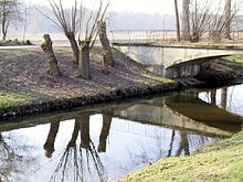
The character bird of the wide meadow areas on the Niers is the strictly protected and promoted little owl , which has its largest occurrence here nationwide. In some places there are rows of pollarded willows as a breeding habitat for the little owl. The gray herons , which find food in wet meadows, ditches, ponds, garden ponds and in fields, have increased significantly . In 2010 a pair of white storks brooded on a nesting aid at the Clörath mill near Viersen .
In the Niers area between Mönchengladbach and Grefrath, several long-disused railway lines known as Vizinalbahnen ran through the area; Well-tended cycle paths (Viersen – Süchteln – Vorst – Krefeld; Viersen – Süchteln – Oedt – Kempen; Viersen – Süchteln – Grefrath – Wankum) are now laid out on their routes. In addition, a network of cycle paths has been created along the Niers.
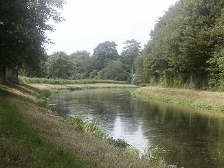
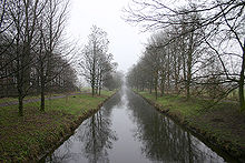
On some stretches, the Niers is more like a canal than a flowing water. Mowed embankments, arched curves, dead straight stretches and an avenue-like planting with deciduous trees ( poplars , acacias ) are typical.
Niers ferries
In addition to numerous bridges over the Niers , self-service ferries enable cyclists and pedestrians to cross the Niers in three places - at a height in meters (m) above sea level; viewed downstream:
- Euroga adventure bridge ferry near Mönchengladbach ; Transporter Bridge with hand-operated cable ( ⊙ ; 36.5 m ; since 2003): between Donk (Moenchengladbach) and Neersen -Cloerbruch (Willich)
- AiWa ferry ( system in the water ) near Wachtendonk ; Rope Ferry with hand operated cranks ( ⊙ ; 28.8 m ; since 2012) is close to the Nice -Einmündung northwest of the core location of Wachtendonk towards Wankum via
- nameless ferry near Weeze ; Cable ferry with hand-operated cranks ( ⊙ ; 14.5 m ; for a long time): between the Jan an de Fähr inn near Wertzhof and the Kalbeck house (south-south-west of Kalbeck Castle ); sets in the municipality of Weeze SSW the national road 77 from the direction of the core center of Goch in the direction of the far away from the core lying Niers local Uedem via
literature
- Stefan Frankewitz : Castles, palaces, mansions on the banks of the Niers. Boss, Kleve 1997, ISBN 3-9805931-0-X .
- Birgit Wilms, Heinz-Gerd Wöstemeyer: In the green land of the Niers. From the source to the mouth. Mercator, Duisburg 2005, ISBN 3-87463-395-0 .
- Robert Lünendonk: The Niers and their mills . From the source to Neuwerk. Ed .: Christian Wolfsberger. 1st edition. Klartext Medienwerkstatt GmbH, Essen, Mönchengladbach 2012, ISBN 978-3-8375-0741-6 .
- Heinrich Linssen: The Niers. A hiked home book in words and pictures. Krefeld n.d. [1940]. Reprint from the magazine "Die Heimat", published by the Verein für Heimatkunde zu Krefeld.
Web links
- Website of the Niers Association
- Electronic water information system (ELWAS) , at the Ministry for Climate Protection, Environment, Agriculture, Nature and Consumer Protection of the State of North Rhine-Westphalia
- History of the source area of the Niers - legend and background from a folklore point of view In: say.at
- The Niers → data + facts . Archived from the original onMay 17, 2014; accessed on August 28, 2016. (see there also fishing information such as → fishing on the Niers)
- Plans for Niers encounter resistance , In: rp-online.de , Rheinische Post , from February 16, 2013
- Niers In: Virtual Museum Erkelenz
Individual evidence
- ↑ a b c German basic map (DGK 5) in Topographical Information Management, Cologne District Government, Department GEObasis NRW ( information )
- ↑ a b c Topographical Information Management, Cologne District Government, Department GEObasis NRW ( information )
- ↑ Goch level
- ^ Leopold Freiherr von Zedlitz-Neukirch: The Prussian state in all its relationships (Volume 1, p. 328) names Xanten - Kalkar - Kleve - Materborn
- ↑ Area directory for the water stationing map of the state of North Rhine-Westphalia ( Memento of the original from October 17, 2013 in the Internet Archive ) Info: The archive link was inserted automatically and has not yet been checked. Please check the original and archive link according to the instructions and then remove this notice. (PDF; 556 kB)
- ^ Rheinische Post: Again life in the Niers , from September 15, 2012, on rp-online.de
- ↑ Niers-Radwanderweg , on www.niederrhein-tourismus.de
- ↑ History at a Glance , Clörather Mühle , on cloerather-muehle.de
- ↑ Bird reports from the Lower Rhine , on vogelmeldung.de
- ↑ On April 2, Clörath gets a second stork's nest , from March 29, 2013, on bz-mg.de
- ↑ New: Small ferry to cross the Niers , from November 19, 2012, on wz-newsline.de (PDF; 373 kB)
- ↑ AiWa (system in the water) , information board on the ferry, accessed on September 1, 2016, from wachtendonk.de
- ^ Print edition "Grenzland-Kurier - Regional", p. C6
