
Nittenau
| coat of arms | Germany map | |
|---|---|---|

|
Coordinates: 49 ° 12 ' N , 12 ° 17' E |
|
| Basic data | ||
| State : | Bavaria | |
| Administrative region : | Upper Palatinate | |
| County : | Schwandorf | |
| Height : | 350 m above sea level NHN | |
| Area : | 98.73 km 2 | |
| Residents: | 9027 (Dec. 31, 2019) | |
| Population density : | 91 inhabitants per km 2 | |
| Postal code : | 93149 | |
| Primaries : | 09436, 09463, 09464 | |
| License plate : | SAD, BUL , NAB , NEN, OVI, ROD | |
| Community key : | 09 3 76 149 | |
| City structure: | 88 districts | |
City administration address : |
Court Street 13 93149 Nittenau |
|
| Website : | ||
| Mayor : | Benjamin Boml (FW) | |
| Location of the city of Nittenau in the Schwandorf district | ||
  |
||


Nittenau is a town in the Upper Palatinate district of Schwandorf and is located near the northernmost point of the Regen river in a wide valley.
City structure
In addition to the main town, the city of Nittenau consists of the following 87 districts:
history
Until the church is planted
The town of Nittenau in the Upper Palatinate, first mentioned in 1007, belonged to the Bavarian Rent Office Amberg and the Wetterfeld district court and had a market court with extensive proprietary rights. The annual and weekly markets from 1345 were of great importance for the surrounding area. In 1779 almost all the buildings in the market, which then had 760 inhabitants, fell victim to a fire. In 1805 and 1809 large parts of the village again burned down. The district of Anger on an unpaved island was almost regularly inundated during floods.

In the course of the administrative reforms in Bavaria in 1818, the market in Nittenau became an independent political municipality as it is today.
19th and 20th centuries
The iron hammer on the Anger, where hoof sticks, hammers, hatchets and agricultural implements were produced, was bought by Maximilianshütte in 1856 and replaced by the larger factory "am Wechsel", which ceased production in 1883. On November 5, 1907, Nittenau received a railway connection through the Bodenwöhr – Nittenau railway line.
Because of a small ironworks, the market was bombed towards the end of the Second World War, and later earth shelling destroyed several residential buildings. The place was elevated to a city in 1953.
Until the regional reform , Nittenau belonged to the Roding district , since July 1, 1972, the city has been assigned to the Schwandorf district .
Incorporations
In 1945 or 1946, the previously independent municipality of Bergham and parts of the municipalities of Plitting, Treidling and Wulkersdorf were incorporated. On July 1, 1971, Bodenstein (with the parts of the municipality of Treidling incorporated in 1945 or 1946), Stefling (with Hof am Regen, which was incorporated in 1945 or 1946) and Untermainsbach (with the rest of the thus incorporated on October 1, 1949) came dissolved municipality of Plitting). Bleich (with the town of Neuhaus incorporated on April 1, 1949) and Kaspeltshub followed on January 1, 1972. On May 1, 1978 Fischbach was added. On November 1, 2013, a piece of the dissolved community-free area Einsiedler and Walderbacher Forst was added to the urban area.
Population development
Between 1988 and 2018, the city grew from 7,377 to 9,019 by 1,642 inhabitants or 22.3%.
politics
City council
The city council election on March 15, 2020 led to the following result:
| CSU | SPD | FW | Green |
|---|---|---|---|
| 6 seats | 4 seats | 8 seats | 2 seats |
| 31.9% | 20.5% | 37.1% | 10.6% |
mayor
1. Mayor is Benjamin Boml (FW).
coat of arms
The coat of arms of Nittenau was awarded by Count Palatine Otto II on November 11, 1468.
Official description of the coat of arms: Divided, above in gold a rooted green sail tree diverging into two trunks, below the Bavarian diamonds.
Town twinning
-
 Přeštice ( CZ ) since 1993
 -
 Lake Zurich ( Illinois , USA ) since 1999
Attractions

- The baroque parish church of Our Lady was built after the fire of 1779, including the Gothic choir and old enclosing walls. It was expanded in 1849 and 1851. In 1978 the Regensburg architect Josef Naumann expanded it further.
- Stork tower, sparrow tower and swallow tower with parts of the old city fortifications
- Bodenstein Castle
- Fischbach Castle (Nittenau)
- Stefling Castle
- Hof am Regen Castle
- Stockenfels castle ruins
- Burgstall Zangenfels
- Burgstall Neuhaus (Nittenau)
Economy and Infrastructure
Krones AG is an important industrial company .
traffic
For aviation to 2/3000 kg maximum take-off weight is the airfield Nittenau-Bruck .
Sons and daughters of the church
- Valentin Stephan Still (1750–1795), Paulaner lay brother and inventor of the Salvator strong beer
- Paul Kagerer (1833–1907), Catholic clergyman and vicar general in Regensburg
- Michael Schottenhamel (1838–1912), first Wies'n host
- Eugen Taucher (1863–1933), Bergham-born judiciary and politician
- Eustachius Kugler (1867–1946), monk of the Merciful Brothers , beatified in 2009
- Franz Xaver Eichinger SVD (born December 2, 1910 in Marienthal near Nittenau, Upper Palatinate, † March 27, 1992 in St. Wendel, Saarland) was a German Steyler missionary and doctor who worked in China from 1940 to 1953.
- Karl Hoffmann (1915–1996), German Indologist and Indo-Europeanist
- Bernd Spiessl (1921–2002), oral and maxillofacial surgeon and researcher
- Georg Ettl (1940–2014 Viersen), artist and art professor
- Heribert Prantl (* 1953), publicist and managing editor of the Süddeutsche Zeitung
- Ernst Seidl (* 1961), grew up in Diepenried, director of the museum at the University of Tübingen MUT and professor of museology and art history
photos
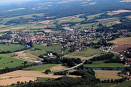
Nittenau (2013)

Bergham (2013)
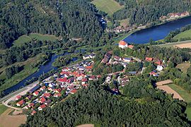
Stefling (2013)

Untermainsbach (2013)
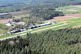
EDNM Airfield (2017)


literature
- Hans Sponholz (Red.): City of Nittenau in the nature reserve of the Bavarian Forest. Publishing house for authorities a. Economy Hoeppner, Munich / Aßling 1972, DNB 720164028 .
Web links
- Website of Nittenau
- Entry on the coat of arms of Nittenau in the database of the House of Bavarian History
Individual evidence
- ↑ "Data 2" sheet, Statistical Report A1200C 202041 Population of the municipalities, districts and administrative districts 1st quarter 2020 (population based on the 2011 census) ( help ).
- ↑ Bavarian State Library Online (BLO)
- ^ Wilhelm Volkert (ed.): Handbook of Bavarian offices, communities and courts 1799–1980 . CH Beck, Munich 1983, ISBN 3-406-09669-7 , p. 559 .
- ^ Federal Statistical Office (ed.): Historical municipality directory for the Federal Republic of Germany. Name, border and key number changes in municipalities, counties and administrative districts from May 27, 1970 to December 31, 1982 . W. Kohlhammer GmbH, Stuttgart / Mainz 1983, ISBN 3-17-003263-1 , p. 668 .
- ^ Official Journal Upper Palatinate: Proclamation , Correction
- ^ Bavarian State Office for Statistics, The State Returning Officer
- ↑ http://festzelt.schottenhamel.de/schh/de/chronik.htm ( Memento from November 18, 2009 in the Internet Archive )

Altendorf | Bodenwohr | Bruck in the Upper Palatinate | Burglengenfeld | Dieterskirchen | Fensterbach | Slip | Guteneck | Maxhütte-Haidhof | Nabburg | Neukirchen-Balbini | Neunburg vorm Wald | Niedermurach | Nittenau | Oberviechtach | Pfreimd | Schmidgaden | Schönsee | Schwandorf | Schwarzach near Nabburg | Schwarzenfeld | Schwarzhofen | Stadlern | Steinberg am See | Stulln | Teublitz | Teunz | Thanstein | Trausnitz | Wackersdorf | Weiding | Wernberg-Koeblitz | Winklarn
Unregulated areas: Wolferlohe
Annahaid | Asang | Auhof | Bachbügl | Bergham | Berghof | Berglarn | Pale | Bodenstein | Brunn | Diepenried | Dobl | Dürrmaul | Eckartsreuth | Eichlgütl | Elendhof | Entermainsbach | Eschlbach | Fichtenhof | Fischbach | Forsting | Geiseck | Goppelshof | Gunt | Hadriwa (Nittenau) | Haiderhöf | Hammer hang | Harthöfl | Harting | Heinzlmühl | Hengersbach | Hinterberg | Hinterkohlstetten | Hof am Regen | Höflarn | Holzheim | Holzseige | Hubhof | Jägerhöhe | Kaaghof | Kaspeltshub | Knollenhof | Royal court | Königsreuth | Lichtenhaid | Lohbügl | Michelsberg | Muckenbach | Mühlenthal | Nerping | New building | Neuhaus | Nittenau | Obermainsbach | Wasteland | Oed | Ottischhof | Reisach | Reuting | Roithof | Roneck | Rumelsölden | Saint Martin | Schoenberg | Schwarzenberg | Spandlhof | Stadl | Stefling | Steinhof | Steinmühl | Straßhof | Straw yard | Sulzmühl | Thann | Tiefenbach | Tiefenhof | Treidling | Trumling | Overpass | Untermainsbach | Vorderkohlstetten | Forest house Einsiedel | Waltenried | Weinting | Weißenhof | Wetzlgütl | Wetzlhof | Cell