Upper Austrian Pre-Alps
| Upper Austrian Pre-Alps | ||
|---|---|---|
| Highest peak | Hoher Nock ( 1963 m above sea level ) | |
| location | Upper Austria | |
| part of | Northern Limestone Alps | |
| Classification according to | AVE 17b | |
|
|
||
| Coordinates | 47 ° 52 ' N , 14 ° 21' E | |
|
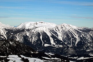
Southwest side. Hoher Nock ( 1963 m ) in the middle, in front of it Hagler ( 1669 m ) and on the right Gamsplan ( 1902 m ). |
||
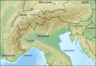
The Upper Austrian Pre-Alps are a mountain group of the Eastern Alps ( AVE 17b), which encompasses the area between the Trauntal ( Gmunden ) in the west and the Ennstal in the east, to Steyr in the north, which is customarily also divided into the Enns and Steyrtal Pre-Alps and the Salzkammergut Pre-Alps (separate around the Steyrtal ). From a political point of view, the area comprises the districts of Steyr-Land and Kirchdorf . Large parts are located in the Kalkalpen National Park .
Delimitation according to the Alpine Club division of the Eastern Alps (AVE)
- Alpine foothills from Gmunden to Waidhofen ad Ybbs - Gaflenz - Enns to Altenmarkt - Laussabach - Hengstpass - Dambach - Windischgarsten - Teichl - Steyr - Weißenbach - Bernerau - Ödseen - Hetzau - Habernau - Moosau - Grieseneckbach - Offenseebach - Traun - Traunsee.
Here are the mountain groups:
Other well-known peaks are:
The Dead Mountains in the south are no longer part of the Prealps, but of the Upper Austrian Limestone High Alps . The AVE divides this into a separate group.
Web links
- Huts in the Upper Austrian Pre-Alps ( Memento from March 4, 2012 in the Internet Archive )


