Reichraminger Hintergebirge
| Reichraminger Hintergebirge | ||
|---|---|---|
|
The Great Largest Mountain |
||
| Highest peak | Großer Großestenberg (Krestenberg) ( 1724 m above sea level ) | |
| location | Upper Austria | |
| part of | Upper Austrian Pre-Alps ( AVE ), Windischgarsten and Reichraminger Alps ( Trimmel ), Enns and Steyrtal Pre-Alps ( NaLa ) | |
|
|
||
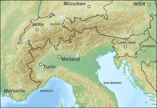
| Coordinates | 47 ° 46 ' N , 14 ° 26' E | |
| particularities | Kalkalpen National Park | |
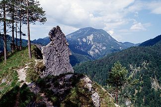
The Reichraminger Hintergebirge is considered the largest closed and practically uninhabited forest area in Austria and belongs to a large extent to the Kalkalpen National Park . It lies on the border between Upper Austria and Styria ( Upper Austrian Pre-Alps or Enns and Steyrtal Pre-Alps ), in the knee of the Enns .
Location and landscape
The Hintergebirge is a domed promontory of the Alps and with the Großer Großestenberg (Krestenberg) reaches a maximum height of 1724 m.
Demarcation, classification, neighboring mountain groups
In general, the Reichraminger Hintergebirge is understood to mean the mountains in the catchment area of the Reichramingbach (Great Bach) , which flows into the Enns at Reichraming . These mountains extend southwest to Windischgarsten , on the Steyr tributary Teichl , and Rosenau on the Hengstpass . There in the south is the main massif of the Hintergebirge. In a broader sense, the entire mountain area between the Ennstal from Reichraming via Großraming and Weyer to Altenmarkt in the east, the Laussatal from the Hengstpass to Altenmarkt (the border with Styria) in the south, and the upper Krumme Steyrling in the west, to the Hintergebirge. A more precise delimitation is relatively arbitrary and is not mentioned in the relevant literature.
Neighboring the Hintergebirge in the north is the Schoberstein range , on the other side of the Enns the Ybbstaler Alps : the massif of the Schieferstein , behind it, to the north, partly reaching as far as the Enns, the lower Enns and Steyrtaler Flyschberge , in the east the mountains of the Gaflenzer follow Kaibling to the Voralpe ( Kalkvoralpen between Ybbs and Enns ) . Sometimes the Dürrensteig ridge to the left of the Enns is seen as an independent group of neighbors. In the south, the Haller Walls of the Gesäuse Mountains and Ennstal Alps are immediate neighbors. The Sengsengebirge rises in the south-west, to the north of it are the mountains near Molln ( Ramsauer Großestenberg - Rotgsol group ).
According to the Alpine Association of the Eastern Alps (AVE), the Hintergebirge belongs to the Upper Austrian Pre-Alps (17b). According to the Trimmel mountain group classification , they belong to the Windischgarsten and Reichraminger Alps (1650) with parts in the Steyrtal Pre-Alps (1660, Schreindlmauer – Schneeberg). According to the regional division of Upper Austria , they belong largely to the Enns and Steyrtal foothills , but the Großtenberg massif is included in the more alpine spatial unit of the Sengsengebirge . The Eisenwurzen area belongs to the traditional landscape .
Outline and summit
The core area of the Reichraminger Hintergebirge is divided into two sub-groups, the Großer Großestenberg ( 1724 m above sea level ) with Alpstein ( 1443 m above sea level ) and neighboring mountains, and the Langfirst group ( 1469 m above sea level ) - Wasserklotz ( 1504 m above sea level ) - Schwarzkogel ( 1554 m above sea level ) - Kampermauer ( 1394 m above sea level ) in the south, which are separated by the uppermost Reichramingbach (Sitzenbach).
The eastern part to the right of the Reichramingbach forms the Dürrensteigkamm , in a broad sense the groups Bodenwies ( 1543 m above sea level ) - Kühberg ( 1415 m above sea level ) and Almkogel ( 1513 m above sea level ) - Ennsberg ( 1373 m above sea level). A. ), as well as the Fahrenberg ( 1253 m above sea level ), which are separated by the Mayerhofer Bach (Hammergraben) near Kleinraming and the Lumplbach near Reichraming. The Dürrensteig ridge or the mountains along the Enns are sometimes not seen as part of the Reichraminger Hintergebirge.
To the left of the Reichramingbach is the Schreindlmauer ( 1293 m above sea level ) - Schneeberg ( 1244 m above sea level ) train, in the north the Hohe Dirn ( 1134 m above sea level ) is sometimes still part of the Hintergebirge
nature
The most remarkable section is the Great Gorge , in which the Reichraminger Bach flows through the back mountains in a deeply cut meandering canyon .
history
Until the end of mining in the 1960s, the area of today's national park was of great economic importance. While there were around 450 houses in the entire catchment area around 1900, today there are only around 70 in number. Forestry was of great importance and the main source of income in the region. Numerous, in some cases well-preserved, remains of drift systems still bear witness to the former importance of this branch of industry.
From the 1920s to 1971, the Reichraming forest railway , which had a track width of 760 mm, was used to transport wood to Reichraming station on three branches, including through the Great Gorge. After they were closed, forest roads were laid out on the railway lines , some of which may now be used by bicycle at certain times and which are signposted as "R9" on the former railway line as the Hintergebirgsradweg .
Mining in the Hintergebirge
The mining has to have been operated in the region for a very long tradition and is likely already in the 12th century north of Laussa. The name Blaberg probably refers to a medieval blow house for smelting iron ore. The mining of iron ore (Bohner ore) on Blaberg and Hochkogel has been proven since the Middle Ages . Gagat began to be dismantled around 1500 . From 1870 on, hard coal was mined on the Sandl . However, these were very small mining operations. In addition, however, significant amounts of bauxite were mined on the Prefingkogel from 1919 . The bauxite deposits mainly contain a mixture of boehmite and hematite . Furthermore, a was Uranylvanadat described, the first as carnotite and later as Metatujamunit was determined. These bauxite bags were created in the Turon in a once hot and humid tropical climate.
The bauxite mining took place in several districts on Prefingkogel. The former grass mining area is located about 200 meters south of the Prefingkogel. The Prefing district is 250 meters to the northeast. The Schwarza Revier is located 100 m west of the Black Brook valley below the bend in the forest road to the Blahbergalm at 700 m above sea level. The raw material for aluminum production was transported via an almost 14 km long material ropeway - the longest in Central Europe - to Weißenbach an der Enns , where the bauxite was loaded onto the railway. Up to 2000 people lived in a 54-house miners' settlement (with a school, an inn and two shops) deep in the forest in Weißwasser near the village of Unterlaussa. In 1964 the mining was stopped because of the complex extraction and the lack of profitability, until 1968 the complete demolition of the miners' settlement and the material ropeway took place. Only a small museum in a replica of a miner's house in the village of Unterlaussa is evidence of the mining tradition in the Reichraminger Hintergebirge.
Kalkalpen National Park
The founding of the Kalkalpen National Park was preceded by several attempts to re-use the area industrially: In 1982, a firing range was planned as a test area for the GHN-45 cannons from the Styrian manufacturer Noricum (subsidiary of VÖEST ), then an extensive storage power plant with a total of three dams , which would have transformed the Großer Bach in the area of the Große Schlucht into a chain of reservoirs . Citizens' initiatives and protest assemblies in the Hintergebirge that were ultimately crowned with success , the most active of which in the summer of 1984 also served as a model for the occupation of the Hainburger Au in the winter of the same year, brought down all of these projects. With the establishment of the Kalkalpen National Park on July 25, 1997, the Reichraminger Hintergebirge was finally placed under protection.
literature
- Adolf Brunnthaler: Reichraming , Verlag Herbert Weishaupt 2000, ISBN 3-7059-0108-7 .
- Otto Harant, Wolfgang Heitzmann: Reichraminger Hintergebirge, Forgotten Mountain Home between Ennstal and Sengsengebirge , Verlag Wilhelm Ennsthaler, ISBN 3-85068-171-8 .
- Nature on the rise - The National Park in the Upper Austrian Limestone Alps , Landesverlag, ISBN 3-85214-683-6 .
- Gerald Radinger: Hiking experience in the Kalkalpen National Park. The most beautiful tours between Enns and Steyr. Kral Verlag, 2012, ISBN 978-3-99024-066-3 .
Web links
- Website of the Reichraming community
- Kalkalpen National Park
- Kalkalpen National Park, Ennstal region
- more information about the Reichraminger Hintergebirge
Individual evidence
- ↑ The Reichraminger Hintergebirge. Website of the Kalkalpen National Park, nationalparkregion.com (accessed October 5, 2018).
- ↑ Hans Jörg Köstler: On the history of mining on iron ore, coal and bauxite in the Unterlaussa in the Reichramingern Hintergebirge. In: Upper Austrian homeland sheets . Volume 48, Issue 1, Linz 1994, pp. 18–46, online (PDF) in the forum OoeGeschichte.at; Unterlaussa is located near Altenmarkt.
- ↑ Hintergebirgsradweg R9 on www.oberoesterreich.at, accessed on January 23, 2018.
- ^ Wittern: Paperback of the mineral sites of Central Europe: Austria. Bode, 1994, ISBN 3-925094-62-8 .
- ↑ Recording report on geological sheet 67 - Großraming ( page no longer available , search in web archives ) Info: The link was automatically marked as defective. Please check the link according to the instructions and then remove this notice. (PDF; 7.1 MB).


