Upper counter
|
Upper counter
Local community Körperich
Coordinates: 49 ° 55 ′ 55 ″ N , 6 ° 15 ′ 4 ″ E
|
|
|---|---|
| Height : | 270 m above sea level NHN |
| Incorporation : | 7th June 1969 |
| Postal code : | 54675 |
| Area code : | 06566 |
|
End of Obersgegen and the environmental park parking lot
|
|
Obers Gegen is a district of the local community Körperich in the Eifelkreis Bitburg-Prüm in Rhineland-Palatinate . Up until June 6, 1969, Obersgegen was an independent municipality.
geography
Obers Gegen is located in the cross-border German-Luxembourg nature park in the Eifel on the geological border (stone layers) between the sandstone of the Gutland and the slate of the Islek . In the northeast Geichlingen and in the east Hüttingen bei Lahr are each about 3 km away. In the south, 1 km away, is Körperich, in the west, 2 km, Roth an der Our and Vianden (4 km), and in the north, Bauler (7 km).
history
Obersgegen was first mentioned in a document in 781 as part of a donation to the Echternach monastery . There the place stands as the Geine super fluvio Geihe ( geihe = Gaybach ) located in pago Ardinense (Ardennes ). This gave rise to the name Jegen, later Gegen. For this purpose, separate focal points with place names were formed, in the north Obersgegen, in the south Niedersgegen , with Körperich in between.
The monastery ownership of land and church was confirmed in 1069 by Pope Alexander II and later again by Pope Viktor IV (1161). The chapel, named in 1570, can still be seen today.
Culture and sights
Buildings
- Obersgegen became famous in recent years through the Gaytalpark environmental and adventure center, which was built in 1996 . The main building is a little above the village, the other stations can be found around Obersgegen. The park is more like an outdoor area of 20 hectares. It was equipped with an adventure trail with 20 information points and action options. The house, which is equipped with solar collectors and solar cells and an energy-producing wind turbine, contains multimedia exhibitions and provides information about renewable energies.
- The Gay Valley Park was closed from July 1, 2011, as the sponsor could not agree on further financing.
- Since May 1, 2016, the building has been operated as a privately owned country hotel and restaurant under a new name.
- The current St. Anthony's Chapel may date from the 15th century. It is mentioned in visitation files from 1570 as a branch of the parish of Roth an der Our. The altar from the beginning of the 18th century, like the sanctuary itself, is still in its original form. Due to the destruction of the building during the repulsion of the Ardennes offensive in 1944/45, it was partially demolished and rebuilt in 1958. Only the chancel comes from the old chapel. The patron saint of the chapel is St. Anthony.
Green spaces and recreation
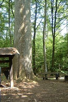
- The 450-year-old royal oak is located in the Kammerwald, about 2 km outside the town center . It measures 475 cm in circumference and is 38 m high. To protect against lightning strikes, it is protected by a lightning rod reaching up to the 18 m crown.
- Hiking in and around Obersgegen
Regular events
- Annual fair or parish fair
- Castle burning on the first weekend after Ash Wednesday (so-called Scheew-Sundich)
literature
- Ernst Wackenroder (arr.): The art monuments of the Bitburg district (= Paul Clemen [Hrsg.]: The art monuments of the Rhine province . Volume 12 / I ). Trier 1983, ISBN 3-88915-006-3 , p. 131–132 (315 p., With 12 plates and 227 illustrations in the text. Reprinted by the Schwann edition, Düsseldorf 1927).
- Catholic parish of St. Hubertus Körperich: 200 years (1790–1990) Parish church of St. Hubertus Körperich. Festschrift Pentecost 1990.
- Leonhard Plazkill: Hikes in the German-Luxembourg border area. Neuerburg 2006.
Web links
- From the school and local history of the village of Obersgegen
- Body and districts ( Memento from April 19, 2007 in the Internet Archive )
- To search for cultural assets in the district of Obersgegen in the community of Körperich in the database of cultural assets in the Trier region .
Individual evidence
- ↑ Official municipality directory 2006 ( Memento from December 22, 2017 in the Internet Archive ) (= State Statistical Office Rhineland-Palatinate [Hrsg.]: Statistical volumes . Volume 393 ). Bad Ems March 2006, p. 183 (PDF; 2.6 MB). Info: An up-to-date directory ( 2016 ) is available, but in the section "Territorial changes - Territorial administrative reform" it does not give any population figures.
- ↑ GaytalPark Environmental Experience Center ( Memento from May 27, 2011 in the Internet Archive )
- ↑ http://www.volksfreund.de/nachrichten/region/bitburg/aktuell/Heute-in-der-Bitburger-Zeitung-Der-Gaytalpark-ist-ab-heute-Geschichte;art752,2831734
- ↑ With pleasure to work: Cooking and eating together in the new country hotel in the Gaytal. Retrieved December 28, 2017 .
- ↑ Entry on chapel (Obersgegen) in the database of cultural assets in the Trier region ; accessed on February 16, 2016.
- ↑ Entry on the royal oak on the Luxembourg border in the database of cultural assets in the Trier region ; accessed on February 16, 2016.
- ↑ Hut Sunday in Malberg Weich. Retrieved August 6, 2018 .
- ↑ Hüttenbrennen in the Eifel. Retrieved May 1, 2016 .
- ↑ Hut Sunday in the Eifel. Retrieved August 10, 2017 .


