
Orscholz
|
Orscholz
municipality Mettlach
|
|
|---|---|
 |
|
| Height : | 418 (167-425) m above sea level NHN |
| Area : | 10.74 km² |
| Residents : | 3611 (May 1, 2019) |
| Population density : | 336 inhabitants / km² |
| Incorporation : | 1st January 1974 |
| Postal code : | 66693 |
| Area code : | 06865 |

The health resort of Orscholz is the largest part of the municipality of Mettlach in the Merzig-Wadern district ( Saarland ). In the climatic health resort there is a rehabilitation clinic of national importance, a forest playground with beer garden and the spa park. Orscholz's " natural landmark " is the Cloef , a rocky vantage point at the top of the Saar loop .
geography
location
Orscholz lies on the Saargau . The upper Saargau is the ridge between the Saar and the Moselle , where it is also called the Moselgau . It begins in the south near Merzig and runs west along the French border. The northern part is bounded by the Moselle and the eastern edge drops steeply towards the Saar valley. The Gaulandschaft is wide and hilly. Orscholz is the capital of the upper Saargau (municipalities of Mettlach and Perl ).
climate

The annual precipitation is 969 mm and is therefore in the upper fifth of the values recorded by the measuring points of the German Weather Service . Over 83% indicate lower values. The driest month is April; it rains most in November. In the wettest month there is around 1.4 times more rain than in the driest month. The seasonal fluctuations in precipitation are in the lower third. In only 13% of all places, the monthly precipitation fluctuates less.
history
The oldest sources call the place Orkelsvels ( Orkelsfelsen ). A Franconian named Orko is said to have built a castle on the site during the time of Charlemagne .
Orscholz was an independent municipality until the end of 1973. On January 1, 1974 Orscholz was incorporated into the municipality of Mettlach.
politics
Mayor
The head of the health resort is Manuel Kerber (CDU).
coat of arms
Blazon : "From a silver oblique beams , in a fallen red key with quatrefoil Ride and linksgewandtem beard, divided by blue and green, above a silver scallop , down a silver globe vase."
Declaration of coat of arms: Orscholz belonged to the dominion of Montclair in the Middle Ages . The Lords of Montclair from the House of Clermont have a silver key as their coat of arms. The key may at the same time refer to the popular interpretation of the name Cloef (the most famous viewpoint in the Saarland) on the spell of Orscholz (from French: la clef = the key). The fiefdom of Montclair was given to the Lords of Sierck in 1427 , whose coat of arms was described as “a red sloping bar in gold, covered with three silver pilgrim shells”. Orscholz remained in the possession of this family and their successors for centuries, which is why a silver scallop shell was placed in the upper blue field.
In the lower green field (below and green should indicate the valley that is deep down as seen from Orscholz) is a silver vase, because the municipality of Orscholz has enjoyed a strong economic boom over the past hundred years due to the employment of many residents in the ceramic industry in Mettlach took.
Worth seeing

- Cloef
- Orkelsfels
- Orscholzriegel of the west wall
- Cloef atrium, architecturally sophisticated event and conference center on the Saarschleife
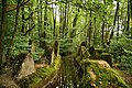
- Premium hiking trails Steinbachtal and Kollesleucker Switzerland
- Treetop path Saarschleife with an approx. 42 meter high observation tower
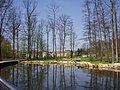
View of Orscholz from the Cloef atrium

View of the Saar loop
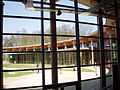
The Cloef Atrium (interior view)

Rehab clinic

Well at the rehab clinic

View of the "Treetop Walk Saarschleife"
The cusp line of the Orscholzriegel at the brickworks between Orscholz and Oberleuken.


literature
- Ernst Wackenroder : The art monuments of the Saarburg district . (= Paul Clemen (Hrsg.): Die Kunstdenkmäler der Rheinprovinz , Volume 15, III. Department). L. Schwann, Düsseldorf 1939 (reprint from the Academic Bookshop Interbook, Trier 1982), pp. 159–160.
Web links
- orscholz-saar.de
- Orscholz on the website of the municipality of Mettlach
- Literature about Orscholz in the Saarland Bibliography
Individual evidence
- ^ Federal Statistical Office (ed.): Historical municipality directory for the Federal Republic of Germany. Name, border and key number changes in municipalities, counties and administrative districts from May 27, 1970 to December 31, 1982 . W. Kohlhammer, Stuttgart / Mainz 1983, ISBN 3-17-003263-1 , p. 804 .
- ↑ Erich Brücker: Orscholz: Manuel Kerber new mayor. Accessed July 31, 2019 .
- ↑ CLOEF-ATRIUM homepage
- ↑ Treetop Walk Saarschleife