
Saar


The Saar (French. Sarre , Latin. Saravus , lux. Sarr ) is a river in the French Alsace and Lorraine ( Grand Est region ) as well as in the German federal states Saarland and Rhineland-Palatinate . With 235 kilometers of flow, it is the longest tributary of the Moselle . The catchment area is 7,431 square kilometers.
The Saar, which arises from its source rivers Rote Saar and White Saar , initially flows through the French region of Grand Est for around 121 km . Between Saargemünd and Saarbrücken-Güdingen , the river forms part of the German-French border over a stretch of around 11 km. The Saar then flows for 68 km through the Saarland named after it to Saarhölzbach , then 31 km through Rhineland-Palatinate to Konz , where it flows from the right into the Rhine tributary Moselle. The Saar drains into the North Sea via the Moselle and Rhine .
Surname
The first written mention of the Saar as Saravus can be found in the poem Mosella by the Roman poet and civil servant Decimus Magnus Ausonius (310–393 AD ). The river name is of pre-Celtic origin and contains as "flowing water" the Indo-European root ser or sar with the meaning to flow , to flow .
geography
course
Source and source rivers


The source rivers of the Saar are the Rote Saar (la Sarre rouge) and the White Saar (la Sarre blanche) . They arise on the Donon (French) and the Hohe Donne (German) in the Vosges, less than 1 km as the crow flies from each other:
The captured source of the Red Saar is located on the D44 road near a former German military cemetery at an altitude of about 785 m . The unmounted source of the White Saar is located near the D993 road from Cirey to Grandfontaine at an altitude of about 710 m . Only a sign indicates the source, which is more difficult to access.
The Saar spring rivers, whose valleys are mostly sunk in the Buntsandstein rocks , are lonely and densely wooded, unite after 26.8 km (Rote Saar) and 26.6 km (White Saar) at Hermelange, south of Sarrebourg , at an altitude of about 262 m .
| length | Catchment area |
Source height |
Water supply |
|
|---|---|---|---|---|
| Red Saar | 26.8 km | 107.3 km² | 785 m | 1.86 m³ / s |
| White Saar | 26.6 km | 80.4 km² | 710 m | 1.60 m³ / s |
Upper Saar

From its source at the confluence of the two source rivers, the Saar crosses the French region of Grand Est for around 121 km . It initially runs in the Moselle department , a short stretch of which also flows through the Bas-Rhin department . In France, the Saar flows through a more rural area and, in the Saarland, an area partly characterized by the coal and steel industry . Of Saaralben (French. Sarralbe) to Saargemünd (French. Sarreguemines) runs parallel to the Saar in sight Saar channel . Near Saargemünd, on the border with Germany, the Blies flows into the Saar as the largest tributary, increasing its water flow (here 19.0 m³ / s) by 20.7 m³ / s and thus more than doubling it.
| flow | EZG in km² | MQ in m³ / s |
|---|---|---|
| Saar | 1784.7 | 19.0 |
| Blew | 1879.2 | 20.7 |
The Blies is therefore the main hydrological strand.
Middle Saar
The Saar is navigable from Saargemünd. As far as Saarbrücken - Güdingen , it forms the German-French border over a stretch of around 11 km; the river Saar in Germany is 114 km long. In the subsequent metropolitan area of the Saarland, the banks of the Saar are almost continuously characterized by settlement and industrial areas. The exit of the Saar north of Sarreguemines occurs in a narrow valley. After the Voltziensandsteinstufe breached near Saarbrücken, the valley widened. However, when the river enters the Saarkohlensattel, the Saar valley narrows again with an almost straight course and narrow floodplain. Especially downstream from Völklingen, there are more narrow valley-like sections. When the Saar enters the Buntsandstein , the valley widens again to form a broad floodplain and very wide terraces. At the confluence of the Prims near Dillingen, the terrace widens very flat. Between Beckingen and Merzig, the Saar valley in the Merziger Graben is box-shaped. The valley is bounded here by the shell limestone steps. Broad terraces can be seen again in the northern red sandstone of the Merziger Graben. The Saar valley narrows sharply again when the river enters the Taunus quartzite of the Hunsrück . Here there are pronounced valley meanders .

Lower Saar
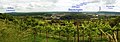
In stark contrast to this is the narrow valley of the Saar through the western Rhenish Slate Mountains from Merzig . At the beginning it forms the well-known Saarschleife near Mettlach and shortly afterwards the "small Saarschleife" near Hamm (center), a district of Taben-Rodt . Between Saarburg and Konz, the Saar valley is characterized by numerous former river loops that break up the undulating plateau and have left behind many surrounding mountains . At the Wiltinger Saarbogen , the former valley courses of the Moselle and Saar even penetrate each other without ever having met there at the same time. The Moselle once flowed at Wiltingen against the current direction of the Saar, but around 85 meters higher, south-east through the Konzer valley of the Konzer Bach . Its localities are now assigned to the Saar as a wine-growing region .
muzzle
Finally , after passing the city center of Konz to the west , the Saar flows under the federal highway 419 at 130.3 m above sea level. NHN in the Rhine- tributary Moselle flowing there from the west-northwest and kinking to the northeast .

Catchment area and tributaries
.jpg)
The Saar catchment area is 7,431 square kilometers, of which 3,826 km² are in France and 3,605 km² in Germany. Its tributaries include orographic allocation (left / right) and - if known - reference to 2nd order flowing waters (II; allocation within the Saarland), length and catchment area size (viewed downstream):
|
Left tributaries :
|
Right tributaries :
|
Localities
In France ( Grand Est region ): Nitting (Nazi era: Nittingen, Rote Saar) , Lorquin (Lörchingen, White Saar) , Hermelange (Hermelingen, confluence) , Imling (Imlingen) , Sarrebourg (Saarburg) , Sarraltroff (Saaraltdorf) , Gosselming (Gosselmingen) , Berthelming (Bartolfingen) , Romelfing (Rommelfingen) , Fénétrange (Finstingen) , Niederstinzel , Diedendorf , Bischtroff-sur-Sarre (Pisdorf) , Zollingen, Sarrewerden ( Saar Werden ) , Sarre-Union , Harskirchen , Keskastel , Sarralbe ( Saaralben) , Herbitzheim , Zetting (Settingen) , Sarreinsming (Saareinsmingen) , Rémelfing (Remelfingen) , Sarreguemines (Saargemünd) and Grosbliederstroff (Großblittersdorf) .
In Germany ( Saarland and Rhineland-Palatinate ): Kleinblittersdorf (Kleinbliederstroff / Bliederstroff-le-Petit) , Saarbrücken (Sarrebruck) , Völklingen (Vœlklange) , Wadgassen (Vadegasse) , Bous (Nazi era: Büsingen an der Saar) , Saarlouis ( Sarrelouis, Nazi period: Saarlautern) , Dillingen / Saar (Diedelange-sur-Sarre) , Rehlingen-Siersburg (Rehling-Siersbourg) , Beckingen (Becking) , Merzig (Mercy) , Mettlach , Saarburg (Sarrebourg-sur-Moselle) , Wiltingen and Konz .
Attractions


The well-known Saar Loop is located between Dreisbach and Mettlach near Orscholz .
Almost immediately on the bank of the Saar is the UNESCO - World Heritage Site Völklingen .
In Saarbrücken there is, among other things, the only typical postmodern park in Germany in its design, the Saarbrücken Bürgerpark , the bank area on the Berlin Promenade , which was redesigned from 2011 to 2014 , the Saarland State Theater from the Nazi era , the Saarbrücken Palace with palace gardens and palace church and castle wall , the BigIsland sandy beach laid out by the bigFM radio station , the old bridge steeped in tradition , the Saaruferwiesen with the Staden recreation area and the Ostspangenpark. There are also two Saar peninsulas and landing stages that are popular with walkers and that are regularly approached by ships, for example the Frohsina (city tours in Saarbrücken , Kleinblittersdorf and Saargemünd ; shuttle trips to Güdingen Schleuse and Sarreguemines Pont la Brasserie du Casino (see below) ), the MS Salü Saarbrücken (city tours in Saarbrücken; stops at the stations Osthafen , Staden , Alte Brücke , Congresshalle and Bürgerpark ), various restaurants and trips on the Strasbourg- Saargemünd-Saarbrücken- Völklingen - Merzig - Saarburg - Trier - Cologne - Rotterdam line .
The Friendship Bridge connects the two communities along the German-French border near Kleinblittersdorf (D) and Großblittersdorf (F) . The Kleinblittersdorf station on the German side , served by the Saarbahn to Saargemünd or Saarbrücken- Riegelsberg , is easily accessible and heavily used by both communities. Furthermore, section 1 of the Saar Canal begins here until it flows into the canalized Saar in Saargemünd Nord .
In Sarreguemines there are the “Brasserie du Casino”, the “les cinémas Forum” and various exhibitions on the disused “Faïenceries Sarreguemines” on the banks of the Saar. The Saar is canalised between Saargemünd Nord and Saargemünd Sud and has many landing stages , as well as a marina with which the river branches off again (now permanently) to the Saar Canal , whereupon these run almost parallel to the Rhine-Marne Canal .

On the lower reaches of the Saar there are 14 sculptures that were created in 2007 as part of the sculpture symposium Sculptures on the River .
The Saar cycle path runs along the Saar from Saarburg (Rhineland-Palatinate) to Kleinblittersdorf or Großblittersdorf, then between this and the Saar Canal, which runs just a few meters further west, to Saargemünd Nord , then again along the Saar and from Saargemünd Süd again between the two to the Rhine-Marne Canal.
economy
shipping
Greater importance was the Saar as a transportation route from the 17th century, when wood ( "Dutch wood") saar down on the Moselle and Rhine to the North Sea rafted was.
The Saar since 1866 from Sarreguemines over the Saar channel (formerly Sarre channel called) with the Marne-Rhine canal connected. In connection with the construction of the Saar Canal, the Saar was canalized from Sarreguemines to Luisenthal and then to Ensdorf in the years 1862 to 1879 , so that it was navigable for Penichen up to this point . The Saar breakthrough at St. Arnual did not take place until 1969.
It was not until 1974 that the lower reaches of the Saar, starting from the mouth, were expanded for large-scale shipping: 1987 opening of the Konz – Dillingen section, 1994 opening of the Dillingen – Lisdorf section, 1999 opening of the Saarbrücken lock, 2001 completion of the extension. The upgraded Konz – Saarbrücken line has a length of 87.2 km with a height difference of 55 m and a channel depth of 3 m. It is a European waterway of waterway class Vb. Standard ships are the European ship with a deadweight of 1,350 t (length: 85 m, width: 9.5 m, draft: 2.5 m) and the push convoy with two barges with a deadweight of 3,320 t (length: up to 185 m, width : up to 11.45 m, draft: 2.5 m). The plan was to expand beyond Saarbrücken, but like other infrastructure measures, it was postponed for political reasons. This is how large-scale shipping ends at the Luisenbrücke in Saarbrücken.

The Saar (Sa) had been a Reichswasserstraße since 1921, today it is administered as a federal waterway from Saargemünd to its confluence with the Moselle at Mosel km 200.81 in Konz over a length of 104.7 km by the Saarbrücken Waterways and Shipping Office. Its kilometers run along the shipping lane, which is around 5.5 kilometers shorter than the original length of the river due to several punctures like the one at Kanzem, the longest. It begins with km 0 in Konz and ends at the beginning of the Franco-German border in Güdingen with km 94.06; from here on the Lorraine mileage counts with km 75.62 to 64.98 near Saargemünd. It continues in France on the Saar Canal.
In the Saarschleife near Dreisbach there is another passenger ferry, the Welles .
Ports
In addition to various yacht and boat harbors, there are industrial harbors in Saarlouis / Dillingen Saarlouis / Dillingen and Völklingen.
Barrages
Eight barrages serve to overcome the height difference of 55 m on the major shipping route Saarbrücken-Konz (total head) (sequence downstream, height differences in brackets):
- Güdingen lock (2.41 m)
- Saarbrücken barrage (5.95 m)
- Lisdorf barrage (3.80 m)
- Rehlingen barrage (8.00 m)
- Mettlach barrage (11.00 m)
- Serrig barrage (14.50 m)
- Schoden weir (5.69 m)
- Kanzem lock (11.75 m)
In Kanzem the locks are located in a 2.9 km long lock canal, weir and hydroelectric power station at the upper end of the 7.8 km long, unchanged Saar section near Schoden ( Wiltinger Bogen ). With a pumping power station next to the locks, the lock water can be pumped back when the water is low so that the Wiltinger Bogen has an ecologically sufficient flow. At all other barrages, the large lock (190 × 12 m), small lock (40 × 6.75 m) (from Kanzem to Rehlingen for passenger and sport shipping), weir, fish lock and hydroelectric power station are next to each other in the river. All large locks have a rotating segment gate as the upper gate and a mitred gate as the lower gate . The weirs usually have 3 openings with pulling segments as a closure; A fish-bellied flap is attached to the segments for fine adjustment of the upper water level. The types of closure at the lock and weir avoided higher structures and achieved a good integration into the landscape.
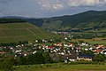
Viticulture
The lower reaches of the Saar between Serrig and Konz is characterized by viticulture . For the Saar wine is Riesling , the most important grape variety. The Saar wine region with Devon - slate floors located in Rhineland-Palatinate and belongs to the German Mosel region . For a long time, viticulture in Saarland only included the Moselle near Perl , where the Elbling grape variety predominantly grows on the limestone soils . At the beginning of the 21st century, the winemaking tradition in the Saarland was revived, with the first vineyards near Saarfels (2002) and Merzig (2007). Up until the First World War, wine was grown on a large scale far above Saarbrücken. Only very few of these vineyards have survived, which are now classified as Saarland country wine again . Some street names still refer to the cultivation of wine, for example the “Weinbergweg” in the Saarbrücken district of St. Arnual and the Winterberg as a corruption of Wingert- Berg.
Vineyard near Beckingen
Vineyard near Merzig (1914)
Ayler Kupp vineyard with Schodener Herrenberg in the background

sport and freetime
Swimming was still allowed in the Saar in the Saarland in the 20th century. There were numerous bathing places, some of them at the mouths of streams into the Saar. There was also a swimming area near the Staden recreation area. For this purpose, the Saarbrücken swimming club even bought a wooden boat from Saargemünd and installed a jumping area for swimmers on it. This boat was part of the beach festival from 1926 to 1939, which was organized by the Saarbrücken swimming club on the site of today's Daarler Bridge . This beach festival took place again from 1947 until swimming in the Saar in Saarland was banned in 1957. This happened because of the industrial wastewater. Even today, swimming is forbidden in the city center of Saarbrücken. The local health authorities also advise against swimming in other parts of the Saarland. So there is also no interest on the part of the Saarbrücken city administration, z. B. in the course of the project Stadtmitte am Fluss to allow swimming in the Saar again.
Nevertheless, festivals take place again today by the river. For example, the Saar spectacle has been taking place on the bank in Saarbrücken every year since 1999 . And in Völklingen there has been the Saarfest since 2002 , which now takes place every two years. Among other things, boat races take place at both festivals.
Replacement transfer points
Replacement crossing points (NATO ramps) are located near Rehlingen - Saarfels and Saarburg - Beurig .
See also
References and comments
- ↑ a b MULEWF Rheinland-Pfalz: Saar ( Memento from March 14, 2013 in the Internet Archive ) , accessed on September 25, 2012
- ↑ discharge values of the Saar estuary
- ↑ Bernhard Kirsch: Why is the Saar called "Saar" or who was there before the Celts? , in: Unser Heimat, bulletin of the Saarlouis district for culture and landscape , 41st year, issue No. 2, 2016, pp. 45–56.
- ^ Johann Jakob Egli : Nomina geographica. Language and factual explanation of 42,000 geographical names of all regions of the world. Friedrich Brandstetter, 2nd edition, Leipzig 1893
- ↑ a b discharge values of the French Saar area (PDF; 24 kB)
- ↑ ( page no longer available , search in web archives: length in sections )
- ↑ a b Débits caractéristiques de la Sarre
- ^ Saar to the confluence with the Blies
- ^ Friedrich Fischer: Contributions to the morphology of the river system of the Saar, work from the Geographical Institute of the University of Saarland, Volume 2, Saarbrücken 1957.
- ↑ Martin Born: Geographical regional studies of the Saarland, Saarbrücken 1980, p. 38.
- ↑ In addition to the Wiltinger Bogen, the lower part of the Saar tributary, the Leukbach valley near Saarburg, has also been artificially shortened, creating the 11 m high Leuk Falls in the city .
- ↑ The allocation of the river terraces to earlier courses of the Moselle and Saar is summarized in a graphic of the geological and natural history trail Ockfen ( Memento from March 4, 2016 in the Internet Archive ). (Note: the assignment of the concert valley, which is left open in the text, is not tenable.)
- ↑ Ruisseau de Gondrexange - Water information system Service d'Administration National des Données et Référentiels sur l'Eau (French) ( information )
- ↑ a b c Rhine-Meuse water data of the Direction Régionale de l'Environnement, de l'Aménagement et du Logement Lorraine (French) ( Notes
- ↑ Landbach - Water information system Service d'Administration National des Données et Référentiels sur l'Eau (French) ( information )
- ↑ Naubach - Water Information System Service d'Administration National des Données et Référentiels sur l'Eau (French) ( information )
- ↑ Directory E, Ser. No. 52 of the Chronicle ( Memento from July 22, 2016 in the Internet Archive ), Federal Waterways and Shipping Administration
- ↑ a b c d Lengths (in km) of the main shipping routes (main routes and certain secondary routes) of the federal inland waterways ( Memento from January 21, 2016 in the Internet Archive ), Federal Waterways and Shipping Administration
- ^ Locks on the Saar - Saarbrücken Waterways and Shipping Office
- ↑ Charly Lehnert : The Saarland Geheichnis, Volume 1: Stories and glosses . Lehnert Verlag, Bübingen 2014, ISBN 978-3-939286-18-9 , Baden in der Saar, p. 213-214 .
- ^ A b Dietmar Klostermann: Authorities are critical of swimming in the Saar. Saarbrücker Zeitung , August 1, 2018, accessed on December 9, 2019 .
- ↑ Martin Rolshausen: When Kaspar Bock provided fun on the Saar. Saarbrücker Zeitung , July 31, 2019, accessed on December 10, 2019 .
literature
- Thomas Strauch: Saar-Coal Canal: ... - A Prussian-French joint project in the 19th century . Yearbook for the Bergmannskalender 2009, pp. 136–150, publisher: RAG Aktiengesellschaft
- M. Eckoldt (Ed.), Rivers and Canals, The History of German Waterways, DSV-Verlag 1998
- Wasser- und Schifffahrtsdirektion Südwest: Compendium of the Wasser- und Schifffahrtsdirektion Südwest. Organizational and technical data, inland navigation, tasks, waterways. Self-published, Mainz June 2007