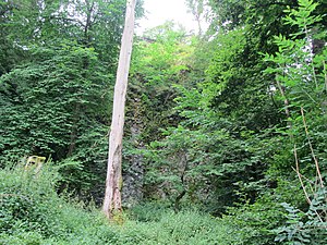
Otter stones
| Otter stones | ||
|---|---|---|
|
The Ottersteine, taken during the 2016 Volkswandertage |
||
| height | 821.3 m above sea level NHN | |
| location | ESE from Dalherda ; District of Fulda , Hessen , Germany | |
| Mountains | Rhön ( High Rhön ) | |
| Coordinates | 50 ° 24 '36 " N , 9 ° 49' 45" E | |
|
|
||
| particularities | - Natural monument - Wildflecken military training area |
|
The Ottersteine are a 823.3 m above sea level. NHN high rock formation, which rises 15 to 25 m above the area and has been designated as a natural monument . It is located in the natural area of Dammersfeld ridge in the Hohe Rhön . Because of its location on the Wildflecken military training area , it is mostly closed to the public.
geography
location
The Ottersteine are a northern branch of the Dammersfeldkuppe in the Hessian Rhön Nature Park and the Rhön Biosphere Reserve . The Hessian - Bavarian border runs around 500 m south-southeast of its summit. Dalherda (Hesse), which belongs to Gersfeld, is about 2 km to the west-northwest . In the east, tributaries of the Rommerser Wasser , called Schmalnau in the lower reaches, arise . The Gichenbach flows past to the west as a tributary of this. The Ottersteine are located in a forest area called Haderwald .
Natural allocation
The otter stones belonged to the natural spatial main unit group Osthessisches Bergland (No. 35), in the main unit Hohe Rhön (354) and in the subunit Südliche Hohe Rhön (354.0) to the natural area Dammersfeldrücke (354.00). Its landscape falls to the north and west in the main unit Vorder- und Kuppenrhön (353) and in the subunit Kuppenrhön (353.2) in the natural area Milseburger Kuppenrhön (353.21).
geology
The cliffs consist of flat-lying columns with a diameter of a few decimeters and pointing in all directions, which indicates an origin as a filling of a volcanic vent through a lava lake. It is not certain whether this chimney, consisting of alkali basalt, promoted the basalt coverings in the area or was independent.
The rock “shows a pronounced flow structure of plagioclase strips with interspersed clinopyroxene and olivine crystals. It encloses individual large olivine xenocrystals ”. These were released from the earth's mantle, but not decomposed quickly enough, which means a rapid ascent of the rock.
Protected areas
Parts of the Haderwald Fauna-Flora-Habitat- Area (FFH-Nr. 5525-352; 17.9486 km²) as well as parts of the bird sanctuary (VSG) Hessische Rhön (VSG-Nr. 5425-401; 360, 8013 km²).
Wildflecken military training area
The Ottersteine are located in the 70 km² training area in Wildflecken ; therefore they are a restricted military area and not freely accessible. Established in 1938 by the German Wehrmacht , the military training area was temporarily used by the US Army after the Second World War . He is currently jointly by the army and its NATO - Allies used. Occasionally, however, the hiking routes of the Volkswandertage pass this formation, which means that they can be viewed from the path. This was last the case in 2016.
literature
- Adalbert Schraft and Heiner Flick: The Hessian Rhön: Geotopes in the land of the open distance . Hessian State Office f. Environment and Geology, Wiesbaden 2013, ISBN 978-3-89026-373-1 , p. 291 ff .
Web links
Individual evidence
- ↑ a b c Map services of the Federal Agency for Nature Conservation ( information )
- ↑ a b c d e Adalbert Schraft and Heiner Flick: The Hessian Rhön: Geotopes in the land of the open distance . Hessian State Office f. Environment and Geology, Wiesbaden 2013, ISBN 978-3-89026-373-1 , p. 292 f .
- ↑ Brigitte Schwenzer: Geographical land survey: The natural space units on sheet 140 Schweinfurt - Federal Institute for Regional Studies, Bad Godesberg, 1968 → Natural space map (PDF, 4 MB).
- ↑ Ulrike Müller and Thomas Pfeuffer: Through dangerous terrain. Rhön- und Saalepost , August 5, 2016, accessed on August 6, 2018 .


