Padar (island)
| Padar (island) | ||
|---|---|---|
| Waters | Sawusee , Floressee | |
| Archipelago | Lesser Sunda Islands | |
| Geographical location | 8 ° 39 '41 " S , 119 ° 33' 36" E | |
|
|
||
| length | 8.7 km | |
| width | 3.6 km | |
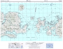
Padar is one of the Lesser Sunda Islands in Indonesia , between the larger neighboring islands of Komodo in the west and Rinca in the east.
It belongs to the province of East Nusa Tenggara ( Nusa Tenggara Barat ).
Padar is uninhabited and with an area of 20.16 km² it is the third largest island in the Komodo National Park after its two neighboring islands . It is of volcanic origin, but drier than its neighboring islands. Up until the 1970s, Komodo dragons were found on Padar . There are several smaller islands around this island.
To the south is to extend Savu Sea belonging Sumbastraße . Sumbawa is located behind the neighboring island of Komodo to the west, separated from the Padar by the " Selat Lintah " strait, notorious for its strong and dangerous currents, and Flores to the east of the neighboring island of Rinca .
Web links
Individual evidence
- ↑ Moritz Jacobi: Indonesia from Sumatra to Sulawesi , p. 440. Ostfildern 2013


