Rinca
| Rinca | ||
|---|---|---|
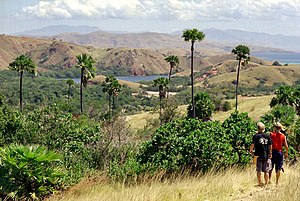
| View of Rinca, 2006 | ||
| Waters | Sawusee , Floressee | |
| Archipelago | Lesser Sunda Islands | |
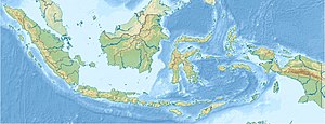
| Geographical location | 8 ° 45 ′ S , 119 ° 42 ′ E | |
|
|
||
| length | 25 km | |
| width | 12 km | |
| surface | 196.25 km² | |
| Highest elevation | Gunung Ora 667 m |
|
Rinca [ rint͡ʃa ] is one of the Lesser Sunda Islands in Indonesia . In the past, the island name was written Rintja .
location and size
The island with an area of 196 km² is of volcanic origin, is located immediately west of Flores and belongs to the province of West Nusa Tenggara . The neighboring islands to the west are the uninhabited, small Padar and Komodo , while in the north there are a large number of tiny islands. In the south, the Sumbastraße and extending Savu Sea to the island of Sumba which, in the north Flores Sea .
population
Around 1000 people live in three towns on the island. Kampung Rinca in the northeast is the largest town, and on the east coast are the small settlements of Kampung Loho Karora and Kampung Loho Baru.
fauna
Rinca is part of the 1980 founded National Park Komodo and famous for the here and on the neighboring island of Komodo are offshore and the uninhabited islands Motang and Kadi, the Rinca in the south, occurring Komodo dragons , but also by many other animal species such as wild boar, buffalo and many species of birds populated.
landscape
Rinca, an island strongly jagged by numerous bays and peninsulas, is 25 km long and up to 12 km wide in the south, but only up to 5 km in the north. The northern part of Rincas, in which most of the inhabitants live, is a savannah characterized by slender Lontar palms , in which wild buffalo, deer, wild horses and wild boars can be found. There is a narrow point only two kilometers wide between the northern and southern parts. The more forested south of the island, where wasps and scorpions also occur, is dominated by the highest elevation, the 667 m high Gunung Ora, which was previously called "Hagedissen Mountain" and whose current name means "Dragon Mountain". The second highest point on the island is the 365 m high Gunung Raja in the northeast not far from Kampung Rinca.
tourism
Day trippers mostly come from Labuan Bajo on Flores by boat, the journey time is about two hours. The landing stage for tourists is at Loh Buaya Bay, where the administration of the national park is also located. Each tourist group is assigned a local guide here. In most cases a hike of around two hours is undertaken. Since Rinca is significantly smaller than neighboring Komodo, the likelihood of seeing Komodo dragons in the wild is greater here. Probably around 1000 of these not harmless animals still live on Rinca. Due to the dangerous nature of the Komodo dragons, which also attack humans, tourists are not allowed to stay outside of the villages in the national park without a local guide. The three villages on Rinca are generally not visited by tourist boats.
Transport links
There are no regular public ferry connections to Rinca or Komodo. Several companies offer day trips from Labuan Bajo to Rinca or Komodo. There is also the option to charter boats. The nearest airport is also in Labuan Bajo.
Individual evidence
- ^ Moritz Jacobi: Indonesia from Sumatra to Sulawesi , Ostfildern 2013, p. 437.
- ^ Moritz Jacobi: Indonesia from Sumatra to Sulawesi , Ostfildern 2013, p. 438.
- ↑ The Komodo National Park on komodo-reise.com
- ^ Catherine Bourzat: Indonésie , Boulogne-Billancourt 2013, p. 521.
- ^ Catherine Bourzat: Indonésie , Boulogne-Billancourt 2013, p. 520.
- ^ Komodo dragon bites elderly woman on Rinca Island. In: The Jakarta Post , October 13, 2012. Retrieved May 8, 2016.


