
Pegestorf
| coat of arms | Germany map | |
|---|---|---|

|
Coordinates: 51 ° 56 ' N , 9 ° 30' E |
|
| Basic data | ||
| State : | Lower Saxony | |
| County : | Holzminden | |
| Joint municipality : | Bodenwerder pollen | |
| Height : | 82 m above sea level NHN | |
| Area : | 8.32 km 2 | |
| Residents: | 374 (Dec. 31, 2019) | |
| Population density : | 45 inhabitants per km 2 | |
| Postal code : | 37619 | |
| Area code : | 05533 | |
| License plate : | HOL | |
| Community key : | 03 2 55 032 | |
| Community structure: | 2 districts | |
| Association administration address: | Münchhausenplatz 1 37619 Bodenwerder |
|
| Mayor : | Dirk Pommer | |
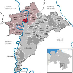
| Location of the municipality of Pegestorf in the Holzminden district | ||
  |
||

Pegestorf is a municipality in Lower Saxony (Germany) in the Holzminden district and part of the Bodenwerder-Polle municipality .
geography
Geographical location
The community is located in the middle of the Weserbergland .
Neighboring communities
Pegestorf borders in the north on Hehlen , in the east on the city of Bodenwerder , in the south on Bevern and in the west on Brevörde and Ottenstein .
Community structure
The municipality of Pegestorf consists of the two districts Pegestorf and Steinmühle.
history
Pegestorf was first mentioned in a document in the year 840 in the Corvey Monastery register with the name "Perderestorpe". In 1330 the place was mentioned in a document from the Counts of Everstein .
politics
Municipal council
After the local elections on September 11, 2011 (voter turnout: 67.84%), the municipal council consists of seven representatives from the Pegestorf community of voters (WG).
mayor
Mayor is Gerlinde Bossow.
Culture and sights
The village church, whose parish belongs to the Holzminden-Bodenwerder parish , was built in 1749.
Above Steinmühle is the Mühlenberg with a refuge and a beautiful view. This is where the Senator Meyer Memorial, built in 1927, commemorates Senator Meyer from Hameln as the founder of passenger steam navigation on the Upper Weser. About 100 m from the stone mill in the direction of Holzminden there is a small cave in the rock. Water gushed out of it continuously until around 1950. The source called Hungerborn has now dried up.
TSV Pegestorf is one of the local clubs.
Individual evidence
- ↑ State Office for Statistics Lower Saxony, LSN-Online regional database, Table 12411: Update of the population, as of December 31, 2019 ( help ).
- ^ History. (No longer available online.) Municipality of Pegestorf, archived from the original on March 14, 2017 ; accessed on March 13, 2017 . Info: The archive link was inserted automatically and has not yet been checked. Please check the original and archive link according to the instructions and then remove this notice.
- ^ Journal of the Historical Association for Lower Saxony, 1868, p. 404
Web links
Arholzen | Bevern | Bodenwerder | Boffzen | Brevörde | Deensen | Delligsen | Derental | Dielmissen | Buckets | Eschershausen | Fürstenberg | Golmbach | Hall | Caves | Heinade | Heinsen | Heyen | Holenberg | Wood | Holzminden | Kirchbrak | Lauenförde | Lenne | Lüerdissen | Negenborn | Ottenstein | Pegestorf | Pollen | Stadtoldendorf | Vahlbruch | Wangelnstedt
Unregulated areas in the district of Holzminden
Boffzen |
Buckets |
Eschershausen |
Green plan |
Holzminden |
Merxhausen |
Wenzen