Pennines
| Pennines | |
|---|---|
|
Location of the Pennines in England |
|
|
Typical landscape in the Pennines |
|
| Highest peak | Cross Fell ( 893 m ASL ) |
| location | Central and Northern England |
| Coordinates | 54 ° 42 ′ N , 2 ° 29 ′ W |
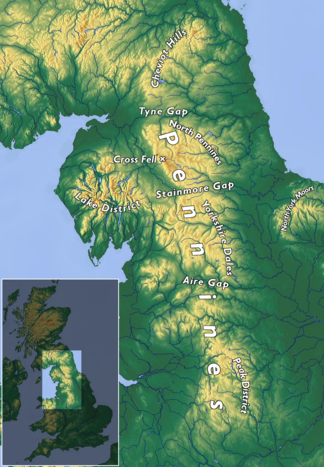
The Pennines [ ˈpɛnaɪnz ] (dt. Pennines ) are around 400 km long low mountain range in England . They run from the Peak District in the Midlands through parts of Greater Manchester , the Yorkshire Dales , the West Pennine Moors in Lancashire and the Cumbria Fells to the Cheviot Hills on the border with Scotland . The Pennines are often referred to as the "backbone of England".
geology
The Pennines were formed from a series of geological structures that together form a broad anticline , the axis of which extends in a north-south direction. It's such a limestone -Ablagerungen from the Carboniferous before that of sandstone layers are superimposed from the same era. Limestone is rising to the surface in the North Pennines and the Peak District. The limestone exposure in the Yorkshire Dales and White Peak resulted in the formation of extensive subterranean cave systems and water courses known in the Yorkshire dialect as gills and pots . Here are some of the largest caves in England; notable examples are the Gaping Gill (107 m deep) and the Rowten Pot (111 m deep). Titan in the Peak District, Britain's deepest known shaft, is connected to the Peak Cavern in Derbyshire, the largest cave entrance in the country. The erosion of the limestone also led to the formation of some unusual geological formations, including the carts in the karst landscape of Malham Cove . Between Skipton and the Peak District is a narrow belt of exposed coarse sandstone.
geography
The highest mountain in the Pennines is the Cross Fell in eastern Cumbria with a height of 893 m. Other significant mountains are Great Dun Fell (848 m), Mickle Fell (788 m), Whernside (736 m), Ingleborough (723 m), High Seat (710 m), Wild Boar Fell (708 m), Pen-y- ghent (693 m), Kinder Scout (636 m) and Black Chew Head (542 m).
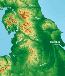
The Pennines form the main watershed in northern England. The River Eden , River Ebble , River Irwell and River Mersey flow west to the Irish Sea . On the other side of the watershed, the River Tyne , Tees , Wear , River Swale , River Ure , Nidd , River Calder , Wharfe , River Aire , River Don, and River Trent all flow east to the North Sea .
Although not very high in absolute terms, the Pennines largely consist of sparsely populated, rough and exposed landscape and are considered to be one of the most charming areas of Great Britain . The Pennines are characterized by an alternation of raised bogs and more fertile river valleys. Major cities lie at the foot of the mountains: Bradford , Leeds and Sheffield to the east and Manchester to the west . The main occupations of the residents are agriculture and livestock, sheep breeding, quarries and tourism; in addition, there are commuters to the surrounding cities.
In the Pennines are the Peak District National Park and the Yorkshire Dales National Park ; Parts of the North Pennines are part of the Northumberland National Park . In addition, the North Pennines and Nidderdale are classified as Area of Outstanding Natural Beauty (AONB), as are Bowland and Pendle Hill . Britain's oldest long-distance footpath , the Pennine Way , runs lengthways through the mountains.
traffic
Some crossings allow transit traffic through the mountain range. Through the Tyne Gap between the Pennines and the Cheviot Hills run the A69 road and the Tyne Valley Line , which provide connections between Carlisle and Newcastle upon Tyne . The most important crossroad of the northern Pennines is the four-lane A66 road with an apex at 441 m altitude between Eden Valley in Cumbria and Teesdale in County Durham . It follows the course of a former Roman road through the Stainmore Gap. The Aire Gap connects Lancashire and Yorkshire via the Aire and Ribble valleys. The A58 road and the A646 road run further south in the Calder Valley between West Yorkshire and Greater Manchester . The M62 motorway , which connects Manchester to Leeds, is the highest motorway in Great Britain: at Windy Hill it reaches a height of 372 m.
Three shipping canals , built during the Industrial Revolution , cross the Pennines. The Huddersfield Narrow Canal between Huddersfield and Manchester runs at Marsden through the 5.2 km long Standedge Tunnel , which is the longest and highest canal tunnel in Great Britain. The Rochdale Canal connects Rochdale via Sowerby Bridge and Manchester. The longest and most northerly canal is the Leeds and Liverpool Canal with the Foulridge Tunnel , which crosses the Pennines at Skipton and connects Leeds with Liverpool .
The London and North Western Railway acquired the Huddersfield and Manchester Railway in 1847 and built a 3-mile single-track railway tunnel parallel to the Standedge Canal Tunnel. This Huddersfield Line is now used by trains operated by First TransPennine Express and Northern Rail . Between 1869 and 1875 the Midland Railway built the Settle – Carlisle line . It runs through the remote regions of the Yorkshire Dales and the Northern Pennines and is considered the most scenic route in England; it is operated by Northern Rail.
Surname
There is no evidence of the current name from before the 18th century. The first use of Pennines is in De Situ Britanniae from 1757. The book contained an alleged account of a Roman general that is said to have survived as a manuscript by a 14th century monk, Richard of Cirencester, for over a century was considered the primary source on Roman Britain . In truth it was a forgery by Charles Bertram, an Englishman living in Copenhagen . In 1853 (after the exposure) Arthur Hussey listed several names in De Situ Britanniae that he could not find in older sources, including the Pennines. Although the name is a recent invention, it had meanwhile passed into common usage and has held up to this day.
In 2004, George Redmonds provided a modern assessment. He notes the absence of any etymological information about the name "Pennines" even in reputable literature on the area, including recognized publications on the origins of place names in Derbyshire and Lancashire. According to Redmonds, this awkward silence stems from a general acceptance among scholars that the name was based on Bertram's forgery. According to Redmonds, however, the comparison with the Italian Apennines has been documented long before that, at least since William Camden , a historian of the Elizabethan era . Bertram only took the inspiration from Camden and popularized it.
The name Pennines was probably accepted willingly because it reminds of names of Cumbrian origin such as Pen-y-ghent in Yorkshire. The most widespread theory of the origin of the word in the Italian Apennines is that it goes back to the Celtic penn , which means "hill" or "mountain". The Croatian linguist Ranko Matasović reconstructed the proto-Celtic root bando (peak, point), which he considers to be of non -Indo-European origin.
Web links
Individual evidence
- ↑ Pennines. Encyclopædia Britannica , accessed August 21, 2013 .
- ^ Writer inspired by beauty of Pennines celebrates its views. Yorkshire Post, October 7, 2008, accessed August 21, 2013 .
- ↑ Spencer Stokes: More than a road… BBC, December 1, 2006, accessed August 21, 2013 .
- ↑ Charles Bertram: Chapter XXXIII . In: Henry Hatcher (Ed.): The Description of Britain, Translated from Richard of Cirencester . J. White and Co, London 1809, pp. 51 .
- ^ Arthur Hussey, A Renewed Examination of Richard of Cirencester . In: Urban, Sylvanus. The Gentleman's Magazine . John Bowyer Nichols and Sons, London 1853, p. 270-273 .
- ↑ George Redmonds: Names and History: People, Places and Things . Hambledon & London, London 2007, ISBN 1-85285-426-X , pp. 65-68 .
- ^ Charlton T. Lewis, Charles Short: Apenninus . In: A Latin Dictionary . Clarendon Press, Oxford 1879.
- ^ Ranko Matasović: Etymological Dictionary of Proto-Celtic. Leiden-Boston, Brill, 2009. ISBN 978-90-04-17336-1 .


