
Podbořany
| Podbořany | |||||
|---|---|---|---|---|---|
|
|||||
| Basic data | |||||
| State : |
|
||||
| Region : | Ústecký kraj | ||||
| District : | Louny | ||||
| Area : | 6015.3258 ha | ||||
| Geographic location : | 50 ° 14 ' N , 13 ° 25' E | ||||
| Height: | 320 m nm | ||||
| Residents : | 6,368 (Jan 1, 2019) | ||||
| Postal code : | 438 01 - 441 01 | ||||
| License plate : | U | ||||
| traffic | |||||
| Street: | Kadaň - Plzeň | ||||
| Railway connection: | Pilsen – Duchcov | ||||
| structure | |||||
| Status: | city | ||||
| Districts: | 13 | ||||
| administration | |||||
| Mayor : | Radek Reindl (as of 2013) | ||||
| Address: | Mírová 615 441 01 Podbořany |
||||
| Municipality number: | 566616 | ||||
| Website : | www.podborany.net | ||||
| Location of Podbořany in the Louny district | |||||

|
|||||


Podbořany (German Podersam ) is a town in the Okres Louny in the Czech Republic .
Geographical location
The city is located in western Bohemia north of the Rakonitzer Uplands in the Saaz pan, 14 kilometers southwest of Žatec ( Saaz ) on the right bank of the Dolánecký potok and is traversed by its tributary Kyselý potok.
Neighboring towns are Vysoké Třebušice in the north, Pšov, Dolánky and Rumplák in the northeast, Letov and Blšany in the east, Očihov in the southeast, Valov in the south, Vroutek in the southwest, Hlubany and Buškovice in the west and Brody and Krásný Dvůr ( Schönhof ) in the northwest.
history

The first documented mention of Podbořany comes from 1369. Podersam and Rudig belonged to the Benedictine monastery in Postelberg and in 1426 came into the possession of the von Guttenstein family. In 1535 the city belonged to the commander in chief of the city troops in the Schmalkaldic War . The Counts of Schlick then became owners. Christoph d. J. Schlick gave Podbořany city rights on November 11, 1575. In 1590 the city consisted of 77 houses. Until the middle of the 17th century Podbořany had seven city gates, the Upper, Lower, Rudiger, Kaadener, Letauer, Prager and Lubauer Tor, which were demolished until 1677. After the city was acquired in 1637 by Duke Julius Heinrich von Sachsen-Lauenburg , in 1689 it passed through his granddaughter to his son-in-law, Margrave Ludwig Wilhelm von Baden-Baden . In 1771 the estates fell to the Bohemian court chamber.
In 1837 Josef Ritter Schreitter von Schwarzenfeld acquired the Podersam estate. He sold it in 1843 to Hugo Karl Fürst and Altgraf zu Salm-Reifferscheid-Krautheim-Raitz. In 1900 it was bought by the Hielle and Dittrich company. As a result of the Czech land reform 1919–1923, the property of the Hielle & Dittrich company was confiscated.
In the second half of the 19th century the city experienced a considerable boom. Industry and commerce settled here. Nearby were kaolin - and Tonwerke operated. The earthenware and oven factory L. & C. Hardtmuth should be mentioned here. Between 1870 and 1872 the railway from Pilsen to Saaz was built by Italians and Croats. Podersam received its own train station in 1873. In 1900 the city had 3,068 inhabitants, of which 2,998 were German-speaking and 38 Czech-speaking.
After the First World War , Podersam was added to the newly created Czechoslovakia in 1919 . In 1934 the city bath was built.
Due to the Munich Agreement of 1938 place came to the German Reich and was until 1945 the district Podersam , Region of Eger , in the Reich District of Sudetenland . After the Second World War , Podersam came back to Czechoslovakia. The German population was expelled between 1945 and 1946 . This resulted in a massacre on June 7, 1945, in which 68 men from Podersam and the surrounding area were killed and then buried in the nearby element forest
In 1960 the Okres Podbořany was dissolved and the town became part of the Okres Louny .
Demographics
| year | Residents | Remarks |
|---|---|---|
| 1783 | k. A. | 119 houses |
| 1830 | 821 | in 147 houses |
| 1843 | 906 | in 157 houses |
| 1869 | 1,649 | |
| 1880 | 2,349 | |
| 1890 | 2,533 | |
| 1900 | 3,068 | German residents |
| 1910 | 3,405 | |
| 1921 | 3,342 | including 2798 German residents |
| 1930 | 3,730 | including 690 Czechs |
| 1939 | 3,198 |
| year | 1970 | 1980 | 1991 | 2001 | 2003 | 2006 | 2009 | 2011 |
|---|---|---|---|---|---|---|---|---|
| Residents | 5 723 | 5 917 | 5 913 | 6 112 | 6 212 | 6 229 | 6 397 | 6 335 |
Local division
The town of Podbořany consists of the districts Buškovice ( Puschwitz ), Dolánky ( Dollanka ), Hlubany ( Lubau ), Kaštice ( Kaschitz ), Kněžice ( Knieschitz ), Letov ( Letau ), Mory ( Mohr ), Neprobylice ( Neprowitz ), Oploty ( Oblat ), Podbořany ( Podersam ), Pšov ( Schaab ), Sýrovice ( Sirbitz ) and Valov ( Wohlau ). The urban area is divided into the cadastral districts of Buškovice, Dolánky u Kaštic, Hlubany, Kaštice, Kněžice u Podbořan, Letov, Neprobylice u Kaštic, Podbořany, Pšov u Podbořan, Sýrovice and Valov. Basic development units are kotvě Buškovice, Dolánky, Hlubany, Kaštice, Ke Krásnému Dvoru, Kněžice, Letov, Mariánská, Mory, Na, Na pískách, Neprobylice, Oploty, Podbořany-jih, Podbořany-sever, Podbořany-sever, Pšov, Rumplák ( lumber mill ) , Sýrovice, U cihelen, U nádraží, Valov and Za Malou Osadou.
gallery

Schiller monument in the city park

Street in the town center

town hall

Czech church
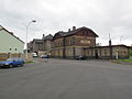
Station building


Town twinning
- Ehrenfriedersdorf , Germany
- Kronach - Since 1986 a home parlor has been set up in Kronach in memory of Podersam / Jechnitz.
Attractions
- Baroque town church of St. Peter and Paul, built in 1781
- Old Town Hall, the baroque building with a mansard roof and turret tower, erected in 1751, is now the city museum and museum of the Volhynientschechen
- Evangelical Messia Church, built between 1901 and 1902
- Lenin monument
- Hlubany water fortress, built in the 2nd half of the 14th century
- Church of the Nativity of Mary in Buškovice, the originally Gothic building from the 14th century was redesigned in 1717 in Baroque style
- Renaissance stone fountain in Kaštice from 1608
- Marian column in Kaštice, from the 18th century
- Parish church of St. Catherine in Kněžice, traceable since 1384
- wooden bell tower in the Kněžice cemetery
- Church of the Visitation of Mary in Letov, built in 1742, served as the burial place of the Barons von Eben. In 1817 the burial chapel of the Knights of Schwarzenfeld was added to the church
- Baroque Church of the Nativity of Mary in Mory
- baroque warehouse in Mory
- Baroque Church of All Saints in Pšov, built in 1767 and renovated after the church fire in 1904
- Chapel of St. John and Paul in Oploty, built in 1722
Personalities
sons and daughters of the town
- Paul Felgenhauer (* 1593 in Puschwitz (Buškovice), † 1677), controversial theologian and chiliast of the Baroque period
- Theodor Hassmann (* 1825 in Podersam, † September 17, 1894 in Saaz ), mayor and member of the state parliament of Saaz
- Josef Turnwald (* 1845 in Podersam, † 1929 in Reichenberg ), politician and writer
- Karl Stanka (* 1883 in Podersam, † 1947 in Radeberg ), painter , draftsman , chronicler
- Eugen Leo Lederer (* 1884 in Podersam, † 1947 in Zandvoort , North Holland), German chemist
- Wolfgang Späte (born September 8, 1911 in Podersam, † April 30, 1997 in Edewecht ): test pilot, bearer of the Iron Cross with oak leaves
- Lucie Hochmann (* 1991), cyclist
Individual evidence
- ↑ http://www.uir.cz/obec/566616/Podborany
- ↑ Český statistický úřad - The population of the Czech municipalities as of January 1, 2019 (PDF; 7.4 MiB)
- ↑ Jaroslaus Schaller : Topography of the Kingdom of Bohemia. Volume 7: Saatzer Circle. Prague and Vienna 1787, pp. 102-103, item 1) .
- ↑ Yearbooks of the Bohemian Museum of Natural and Regional Studies, History, Art and Literature . Volume 2, Prague 1831, p. 199, paragraph 14.
- ↑ Johann Gottfried Sommer : The Kingdom of Bohemia . Volume 14: Saaz Circle , Prague 1846, p. 265, item 1).
- ^ Meyer's Large Conversational Lexicon . 6th edition, Volume 16, Leipzig and Vienna 1908, p. 58 .
- ^ Sudetenland Genealogy Network
- ^ A b Michael Rademacher: German administrative history from the unification of the empire in 1871 to the reunification in 1990. Podersam district (Czech: Podborany). (Online material for the dissertation, Osnabrück 2006).
- ↑ http://www.czso.cz Czeski Urząd Statystyczny
- ↑ http://www.uir.cz/casti-obce-obec/566616/Obec-Podborany
- ↑ http://www.uir.cz/katastralni-uzemi-obec/566616/Obec-Podborany
- ↑ http://www.uir.cz/zsj-obec/566616/Obec-Podborany