Prien (river)
| Prien | ||
|
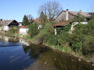
The Prien, running through Prien |
||
| Data | ||
| Water code | EN : 1846 | |
| location |
Tyrol
|
|
| River system | Danube | |
| Drain over | Chiemsee → Alz → Inn → Danube → Black Sea | |
| source |
Spitzstein 47 ° 42 ′ 3 ″ N , 12 ° 14 ′ 28 ″ E |
|
| Source height | approx. 1140 m above sea level NHN | |
| muzzle | east of Rimsting in the Chiemsee Coordinates: 47 ° 52 '33 " N , 12 ° 21' 31" E 47 ° 52 '33 " N , 12 ° 21' 31" E |
|
| Mouth height | 518 m above sea level NHN | |
| Height difference | approx. 622 m | |
| Bottom slope | approx. 14 ‰ | |
| length | 45.7 km of which - roughly measured - 6 km lake line in the Chiemsee to that of the Bernauer Achen |
|
| Catchment area | 261.74 km² including the - roughly measured - 28 km² sub- catchment area of the Chiemsee from the influence of the Prien in its bay to the lake line of the Bernauer Achen |
|
| Discharge at the Prien A Eo gauge : 97.6 km². Location: 3.3 km above the mouth |
NNQ (02/24/1963) MNQ 1951–2006 MQ 1951–2006 Mq 1951–2006 MHQ 1951–2006 HHQ (08/12/2002) |
60 l / s 824 l / s 3.52 m³ / s 36.1 l / (s km²) 66.3 m³ / s 163 m³ / s |
The Prien is a river mainly in the Bavarian district of Rosenheim and one of the longest torrents in the Bavarian Alps .
Surname
The name is probably derived from the Celtic name for the river ( Brigenna = "the one coming from the mountains"). The river gave its name to Prien am Chiemsee .
geography
course
The Prien rises south of the Spitzstein at just under 1149 m above sea level. NN at the Goglalm in the community of Erl in the Tyrolean district of Kufstein close to the border with Bavaria . Only a comparatively small part of the catchment area and the course is on the Austrian side of the border.
The water initially flows to the Kirchdorf Sachrang in the Bavarian municipality of Aschau im Chiemgau , from where it runs north-northeast for a long time through a shallow mountain valley next to the ST 2093. After Aschau itself, the valley widens and the mountain ranges end on the right and left. From here the Prien swerves to the northwest to near Frasdorf , where the A 8 crosses the river, which then runs again in a north-northeast direction, now in valley meanders through a hilly landscape.
After crossing the largest town on its banks, the Prien am Chiemsee market, the last thing it bends to the east is the east of the main town of Rimsting near Bad in the “Schafwaschener Bucht” of the Chiemsee .
After the Tiroler Achen, the Prien is the second largest tributary of the Chiemsee.
Tributaries
From the origin to the mouth in the Chiemsee. Selection.
- Talgraben (right) , near Aschau im Chiemgau -Berg
- Schwarzenbach (left) , near Aschau-Huben
- Schachner Graben (right) , just before the next one
- Kohlstätter Bach (left) , near Aschau-Innerwald
- Niedersberg-Graben (left) , at the beginning of Aschau-Grattenbach
- Grattenbach (right) , in Grattenbach
- Weißenbach or Klausenbach (left) , at the end of Grattenbach
- Wildgraben) (left) , in front of Aschau-Stein
- Oberbach (left) , across from Aschau-Hainbach
- Klausgraben (left) , near Hainbach
- Schoßbach (left) , near Aschau-Schloßrinn
- Floderbach (left) , at Aschau-Einfang
- Wasserthalgraben (right) , in Aschau-Bach
- Steinbach (left) , in Aschau-Hammerbach
- Zellgraben (left) , in Aschau-Weidachwies
- Beerbach (right) , near Aschau-Hohenaschach
- Fuchsluger Bach (right) , at the beginning of Aschau-Aufham
- Lochgraben (right) , in Aufham
- Hammerbach (left) , in Aschau itself; crosses the aforementioned cell trench beforehand
- Schindelbach (left) , to Aschau-Grünwald,
- Schafelbach (right)
- Ebnater Achen (left) , near Frasdorf
- Giebinger Graben (right) , opposite Frasdorf-Wildenwart; is last Grenzbach between Bernau am Chiemsee on the left and Prien am Chiemsee on the right
- Strattener Bach (left) , at Prien-Siggenham over a short end piece of an engine duct to the left of the Prien
- → Departure of the Mühlbach (to the right) , at Prien-Trautersdorf, which flows southeast to the Chiemsee
- Bahngraben (left) , near Rimsting -Westernach
Individual evidence
- ↑ a b Length and catchment area of the Prien according to: List of brook and river areas in Bavaria - Inn river area, page 47 of the Bavarian State Office for the Environment, as of 2016 (PDF; 2.8 MB) (number of pages may change.)
- ^ Deutsches Gewässerkundliches Jahrbuch Danube region 2006 Bavarian State Office for the Environment, p. 247, accessed on October 4, 2017, from: bestellen.bayern.de (PDF, German, 24.2 MB).

