
Röhl
| coat of arms | Germany map | |
|---|---|---|

|
Coordinates: 49 ° 56 ' N , 6 ° 35' E |
|
| Basic data | ||
| State : | Rhineland-Palatinate | |
| County : | Eifel district Bitburg-Prüm | |
| Association municipality : | Bitburger Land | |
| Height : | 340 m above sea level NHN | |
| Area : | 10.65 km 2 | |
| Residents: | 441 (Dec. 31, 2019) | |
| Population density : | 41 inhabitants per km 2 | |
| Postal code : | 54636 | |
| Area code : | 06562 | |
| License plate : | BIT, PRÜ | |
| Community key : | 07 2 32 111 | |
| Association administration address: | Hubert-Prim-Strasse 7 54634 Bitburg |
|
| Website : | ||
| Local Mayor : | Bruno Wallenborn | |
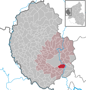
| Location of the local community Röhl in the Eifelkreis Bitburg-Prüm | ||
  |
||

Röhl is a municipality in the Eifelkreis Bitburg-Prüm in Rhineland-Palatinate . It belongs to the Verbandsgemeinde Bitburger Land .
Geographical location
Röhl is located in the South West Eifel , about 5 km southeast of the center of the district town of Bitburg . The extreme east of the municipal area is traversed by the Kyll , in the northwest the border is formed by the Bitburg airfield . Of the district Röhls, which is quite large at 10.65 km², a comparatively small proportion of 50% is used for agriculture, 41% are forest. Röhl to include the residential places Altheiderhof, Freu DERS yards, Moltke castle restaurant, New Pfalzkyllerhof and Pfalzkyll.
history
Several finds of stone axes from the Neolithic Age testify to the very early settlement of the municipality . There are also numerous remains from Roman times , including evidence of an earlier iron melt. 634, Röhl, as well as the places Welschbillig , Newel and Sülm with their churches and affiliations of King Dagobert I (rule: 622 to 638, stay in Trier: 624 to 625) were given to the Church of St. Paulinus ( Paulinstift Trier ). At that time Modoald was Bishop of Trier. In 981 this donation is mentioned in a document from Archbishop Egbert von Trier (Bishop from 977 to 993). Röhl is mentioned for the first time under the name "Rula" in the document mentioned.
- Statistics on population development
The development of the population of Röhl, the values from 1871 to 1987 are based on censuses:
|
|
politics
Municipal council
The local council in Röhl consists of eight council members, who were elected by a majority vote in the local elections on May 26, 2019 , and the honorary local mayor as chairman.
coat of arms
|
|
|
| Justification of the coat of arms: The coat of arms represents a globe closed by a semicircle with a red spread cross and three cross nails in a golden shield. This symbolizes the court and jury seal, which was used by the court, which was located in Röhl until the 18th century. |
Attractions
The Catholic Church of St. Martin was built in 1813 on one of the seven remains of Roman settlements in the area and is now a branch church of the Sülm parish . Several old farmhouses are also worth seeing. Hof Pfalzkyll is located in the north-eastern municipality, a former estate of the Himmerod Abbey from the 18th century. There is another sacred building there: a court chapel from 1920/21.
See also: List of cultural monuments in Röhl
societies
There are currently several associations in the local community. The largest among them is the music association "Eifelland" Röhl, followed by FC Röhl 1957 e. V., the volunteer fire department Röhl and the youth group Röhl. In addition to these associations, there is also the local community support association, the Schwarz Weiß Röhl carnival society and the Röhl men's club.
Web links
- Local community Röhl on the website of the Verbandsgemeinde Bitburger Land
- To search for cultural assets of the local community Röhl in the database of cultural assets in the Trier region .
Individual evidence
- ↑ State Statistical Office of Rhineland-Palatinate - population status 2019, districts, communities, association communities ( help on this ).
- ↑ a b State Statistical Office Rhineland-Palatinate: Regional data.
- ↑ State Statistical Office Rhineland-Palatinate (ed.): Official directory of the municipalities and parts of the municipality. Status: January 2019 [ Version 2020 is available. ] . S. 108 (PDF; 3 MB).
- ^ The Regional Returning Officer Rhineland-Palatinate: Municipal elections 2014, city and municipal council elections
Bath | Balesfeld | Baustert | Bettingen | Bickendorf | Biersdorf am See | Birtlingen | Brecht | Brimingen | Burbach | Dahlem | Dockendorf | Dudeldorf | Echtershausen | Ehlenz | Enzen | Esslingen | Etteldorf | Feilsdorf | Flowem | Gindorf | Gondorf | Gransdorf | Halsdorf | Hamm | Heilenbach | Hütterscheid | Hüttingen an der Kyll | Idenheim | Idesheim | Ingendorf | Kyllburg | Kyllburgweiler | Ließem | Malberg | Malberg soft | Meckel | Messerich | Metterich | Mülbach | Nattenheim | Neidenbach | Neuheilenbach | Niederstedem | Niederweiler | Oberkail | Oberstedem | Oberweiler | Oberweis | Olsdorf | Orsfeld | Pickleneem | Rittersdorf | Röhl | Saint Thomas | Sharply cheap | Schleid | Seffern | Seffer soft | Field of being | Steinborn | Stockem | Sülm | Trimport | Usch | Wettlingen | Wiersdorf | Wilsecker | Wissmannsdorf | Wolsfeld | Zendscheid