
Röthbach Falls

The Röthbachfall is a waterfall at the southern end of the Königsee valley in the Berchtesgadener Land district of Bavaria .
The Röthbach falls south of the Obersee below the Röth over the Röthwand in two main stages almost vertically downwards. The height is generally given as approx. 470 meters and thus, as is often the case, includes the subsequent torrent section. A minimum height of 350 meters can be read from the Alpine Club map of the area (scale 1: 25,000, sheet 10/1, Steinernes Meer ), a site inspection resulted in 380 meters. The upper main stage begins at 1250 m and, apart from small steps, overcomes 240 meters, the lower 50 meters to the torrent section at 870 meters. This makes it - just before the Landtalfall ( ⊙ ) 700 meters to the north - the highest waterfall in Germany.
The water of the Röthbachs and further outpouring from the surrounding rocks of smaller streams seeps through the boggy Almboden the Fischunkel , a valley at the base of Talschlusses, in the group consisting of loose boulders valley floor and fed as groundwater flow underground the upper lake , which in turn over the Saletbach in drains the Königssee . Only when the Röthbach has a strong water flow, around the time the snow melts , does a small lake temporarily form in the depression.
The Röthbach Waterfall is absolutely typical of the most common in higher latitudes original cause very high waterfalls: the Ausschürfung an abrupt Trogtal statements by the emergent at such places glacial glacier stream ( Konfluenzstufe ). The best- known example is the Gavarnie Falls in the Pyrenees .
Hikers can reach the waterfall most comfortably from the boat stop Salet of the Bavarian Königssee-Schifffahrt , past the Fischunkelalm , in a one-hour walk (one way approx. Four kilometers).
The better-known Triberg waterfalls in the Black Forest , which are often incorrectly referred to as the highest waterfalls in Germany, are only 163 meters high, but much better developed for tourists.

The Röthbachfall during the snowmelt in May with the lake that only forms temporarily at the bottom of the Fischunculus

Deep view, when the water is low in October
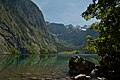
The Röthbachfall at the end of the Königssee valley, seen over the Obersee and the Fischunkelalm


See also
Web links
- Röthbachfall and Landtalfall (360 ° panorama)
- Röthbachfall (private homepage)
- blog.berchtesgadener-land.com about the Röthbachfall
Individual evidence
- ↑ Ursula and Wolfgang Eckert: The Berchtesgadener Land. From the Watzmann to the Rupertiwinkel. DuMont landscape guide . DuMont Buchverlag, Cologne 1992, ISBN 3-7701-2514-2 , p. 127.
Coordinates: 47 ° 30 ′ 10 ″ N , 13 ° 0 ′ 42 ″ E