
Triberg waterfalls
| Triberg waterfalls, main steps | ||
|---|---|---|
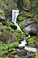
 Triberg waterfalls, the lower 4 of the 7 main levels |
||
| Coordinates | 48 ° 7 '33.96 " N , 8 ° 13' 37.56" O | |
|
||
| place | Triberg , Central Black Forest , Baden-Wuerttemberg | |
| height | 92 m drop edge : 805 m impact zone : 713 m |
|
| width | 10 m | |
| Number of fall levels | 7th | |
| Mean flow rate (MQ) | 650 l / s | |
| Falling watercourse | Gutach (Kinzig) | |

The in Triberg located Triberg Waterfalls , with their total of 163 meters height to the highest and most famous waterfalls in Germany. After the Gutach has formed from the streams of the many hollow valleys of the Schönwalder plateau, it plunges over mighty granite steps into a wooded valley basin that opens directly into the center of Triberg. The Triberg waterfalls are divided into two cascade groups: The upper falls with three main levels fall from 872 m to 856 m above sea level. NHN . After a steep stream section, the well-known seven-step main falls follow, which rise from about 805 m to 713 m above sea level on a running distance of approx. 230 meters . Crash NHN .
On partly well-developed, asphalted paths with two wooden bridges, you can hike the varied falls. They are illuminated until 10:00 p.m., some of them can be walked on even in winter and are a special sight when the falls are icy.
The waterfalls have five entrances: in the city center directly on the B 500 , on Bergsee, on Scheffelplatz, on Adelheid and behind the Asklepios Clinic .
Emergence

The Triberg waterfall basin lies, together with the neighboring mountain lake , in a series of Ice Age cirques that are typically deepened into the northeast slope of the Schönwald plateau. This steep slope , known in Triberg Wasserfallberg , is part of a pronounced, straight valley (typical of the breakdown zone of a fault ) that runs transversely to the northeastern direction of flow of the Gutach ( Schonach- German line ) and forms the Triberg basin at the intersection with the Gutach. Just like the Gutach, the rivers of the valley crossing the valley, the Schonach (sliding fall of 8 meters) and the Prisenbach (small cascades), both in the middle of urban development, plunge into this basin, albeit less spectacularly . Such a situation with valley steps facing each other is typical for a confluence step of Ice Age glaciers. The kar-like forms, including the waterfall basin, probably received their last transformation in the high glacial of the Würm Ice Age , the lower valley steps only in older, more extensive glaciations.
Another important contribution to the steepness of the Triberg basin is made by the Kesselberg Fault , which crosses 1.5 km below the waterfalls and is characterized by a 50–100 m high step and has accordingly increased the slope of the Gutach.
The very different shapes of the individual steps are easily recognizable by the wide gap pattern in the surrounding so-called Triberg granite . The larger of the cascades also have a certain tendency to self-reinforce, as the erosion is strongest in the pools at the foot of such steps.
Economic and cultural importance

| Triberg waterfalls, upper steps | ||
|---|---|---|
.jpg) Triberg waterfalls, upper steps |
||
| Coordinates | 48 ° 7 '27.35 " N , 8 ° 13' 24.97" E | |
|
||
| height | 16 m drop edge : 872 m impact zone : 856 m |
|
| width | 5 m | |
| Number of fall levels | 3 | |
| Mean flow rate (MQ) | 650 l / s | |
| Falling watercourse | Gutach (Kinzig) | |
In 1805 the waterfalls were made accessible by secured paths under the governor Theodor Huber . Around the middle of the 19th century, waterfall tourism increased significantly due to the construction of new traffic routes such as the Black Forest Railway and now outweighed the proportion of traditional Triberg pilgrimages to the Virgin Mary .
The hydropower of the falls was the prerequisite for the city of Triberg's venture, in 1884, to be the first in Germany to install electric street lighting. Even today, the gradient above and below the main fall area is used hydroelectrically.
Around 500,000 day trippers and tourists from home and abroad visit the Triberg waterfalls every year. There is a fee to enter. The short visits to the cases have a major impact on the local tourism industry, a problem that has long been attempted to address.
They received the title of Germany's most beautiful natural wonder from a magazine . Triberg has long been postulating the title of Germany's highest waterfalls , in competition with the only 97 meter high Todtnau waterfalls , which, also factually incorrectly, can be described as the highest natural waterfalls in Germany. The height of both waterfalls is far exceeded, however, by the lesser-known Röthbachfall on Königssee , which is only accessible on foot , with almost 470 meters in Germany's highest waterfall, as well as the 200-meter-high Kuhflucht waterfalls and the Königsbachfall.
Nevertheless, the Triberg Falls are undisputedly the classic waterfalls in Germany. Through the large number of artistic adaptations of their dark forest romantic pathos (many pictures in the Badisches Landesmuseum Karlsruhe) and a very active marketing, also abroad, they have significantly shaped the German conceptual image of waterfall .
1st main level

3rd main level

4th main level

Lower steps


See also
literature
- Geographical-Cartographic Institute Meyer (1989): Southern Black Forest (Meyers Naturführer). Meyers Lexikonverlag, Mannheim, ISBN 3-411-02775-4 .
- W. Müller: Triberg . Portrait of a city. Triberg.
Web links
Individual evidence
- ^ Electrical lighting , in the Centralblatt der Bauverwaltung , No. 23, June 11, 1884, pp. 239 and 240, accessed on January 4, 2013