
Rüschlikon
| Rüschlikon | |
|---|---|
 |
|
| State : |
|
| Canton : |
|
| District : | Horgen |
| BFS no. : | 0139 |
| Postal code : | 8803 |
| Coordinates : | 684 513 / 240429 |
| Height : | 444 m above sea level M. |
| Height range : | 406-585 m above sea level M. |
| Area : | 2.93 km² |
| Residents: | 6035 (December 31, 2018) |
| Population density : | 2060 inhabitants per km² |
|
Proportion of foreigners : (residents without citizenship ) |
33.2% (December 31, 2018) |
| Mayor : | Bernhard Elsener ( CVP ) |
| Website: | www.rueschlikon.ch |
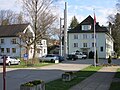
 Train station and village from the church tower |
|
| Location of the municipality | |
  |
|
Rüschlikon is a municipality in the district of Horgen in the canton of Zurich in Switzerland . Rüschlikon is about eight kilometers south of the city of Zurich on the left bank of Lake Zurich .
geography
Rüschlikon stretches from Lake Zurich over the entire Zimmerberg to the Sihl River . The predominantly built-up settlement area of Rüschlikon lies north of the Zimmerberghöhe.
In Rüschlikon there are large green areas on the southern slope that are used as a local recreation area: in the west the Chopfholz forest , along the Sihl the Sihlhalde forest area . The forests at the height of the Zimmerberg are called Weissberg , Eggrain , Spitelegg and Langtannen with field names . The Leilöcher ( clay holes ), a boggy plain, lie between the Spitelegg and Langtannen forest areas . The fields Hinter- and Vorder- Längimoos and the cattle pasture on the southern part of Rüschlikon are farmed extensively.
history
The oldest witnesses of the settlement are a series of burial mounds from the Iron Age Hallstatt culture (800–450 BC) on the moraine of the Zimmerberg. The name Rüschlikon is of Alemannic origin and is mentioned in a document around the middle of the 12th century as Ruochslinchon and Ruoslinchoven . Thanks to the intact village center and the local museum, the history of Rüschlikon remains comprehensible.
coat of arms
- Two-leaved stem of a double rose with red clusters and green sepals.
politics
Bernhard Elsener ( CVP ) has been mayor since 2006 (as of December 2017).
Attractions
building
- The sulphurous healing spring Nidelbad was known from 1500. Conrad Gessner mentioned them in his book Heilquellen der Schweiz from 1553. In 1870 the Kurhaus was rebuilt.
- Group of buildings consisting of a wine grower's house built in 1786, a wash house built in 1804 and a large barn on Alte Landstrasse.
Churches
There are two churches in Rüschlikon:
- The reformed church goes back to a medieval Niklaus chapel. In the 18th to 20th centuries, various alterations and extensions to the church took place, so that today it presents itself as a transverse church .
- The name of the Roman Catholic Church of St. Nikolaus takes up the medieval patronage of Rüschlikon to St. Nicholas of Myra . It was built between 1980 and 1982.
gallery

Rüschlikon, historical aerial photo from 1919, taken from a height of 100 meters by Walter Mittelholzer
former spa and spa «Nidelbad»

Wine farm from 1786

Rüschlikon 1793, on an engraving by Heinrich Brupbacher


Institutions
Three think tanks have settled in Rüschlikon:
- The Gottlieb Duttweiler Institute (GDI), an institution sponsored by the Migros retail cooperative , at the former residence of the company founder Gottlieb Duttweiler , the Park im Grüene
- The IBM Zurich Research Laboratory , which has produced several Nobel Prize winners and is one of the oldest think tanks of the computer manufacturer IBM .
- The Center for Global Dialogue of the Swiss Reinsurance Company ( Swiss Re ), one of the largest reinsurance groups in the world, in the “Villa Bodmer”.
Personalities
- Max Bucherer (1883–1974), painter and graphic artist
- Willy Friedrich Burger (1882–1964), art and poster painter
- Adele Duttweiler (1892–1990), wife of Gottlieb Duttweiler
- Gottlieb Duttweiler (1888–1962), politician, entrepreneur and founder of Migros
- Ivan Glasenberg (* 1957), entrepreneur and manager (Glencore), has lived in Rüschlikon since 1994
- Fritz Honegger (1917–1999), Federal Councilor from 1977–1982, father of Eric Honegger
- Eric Honegger (* 1946), councilor and manager, son of Fritz Honegger
- Hans-Jürg Meier (1964–2015), composer, recorder player and choir director, grew up in Rüschlikon
- Karl Alexander Müller (* 1927) and Georg Bednorz (* 1950), Nobel Prize winners for Physics 1987
- Marcel Reif (* 1949), TV journalist and sports commentator, lives in Rüschlikon
- Monika Ribar (* 1959), manager, lives in Rüschlikon
- Heinrich Rohrer (1933–2013) and Gerd Binnig (* 1947), 1986 Nobel Prize laureates for physics
- James Schwarzenbach (1911–1994), politician, born in Rüschlikon
literature
- Bernhard Schneider , Erika Schmid (photography and design): Contrasts in Rüschlikon Verlag Schneider Communications 2013, ISBN 978-3-906068-01-5 .
- Hermann Fietz: The art monuments of the canton of Zurich, Volume II: The districts of Bülach, Dielsdorf, Hinwil, Horgen and Meilen. (= Art Monuments of Switzerland. Volume 15). Edited by the Society for Swiss Art History GSK. Bern 1943. DNB 365803049 .
Web links
- Martin Illi: Rüschlikon. In: Historical Lexicon of Switzerland .
- Official website of the municipality of Rüschlikon
- Statistical data for the municipality of Rüschlikon
Individual evidence
- ↑ Permanent and non-permanent resident population by year, canton, district, municipality, population type and gender (permanent resident population). In: bfs. admin.ch . Federal Statistical Office (FSO), August 31, 2019, accessed on December 22, 2019 .
- ↑ Data on the resident population by home, gender and age (community profile). Statistical Office of the Canton of Zurich, accessed on December 22, 2019 .
- ^ Walter Drack: The Hallstatt grave hill II near Feldimoos, municipality of Rüschlikon, Canton of Zurich . In: Journal for Swiss Archeology and Art History . 25, 1968, pp. 177-188. doi : 10.5169 / seals-165210 .
- ^ Heimatschutzforum Zürich: Particularly valuable group of buildings at Alte Landstrasse 110, Rüschlikon
- ↑ The Nidelbad. In: NZZ from May 15, 1938.
Adliswil | Horgen | Kilchberg | Langnau am Albis | Oberrieden | Richterswil | Rüschlikon | Thalwil | Waedenswil
Former parishes: Hirzel | Huts | Schönenberg
Canton of Zurich | Districts of the Canton of Zurich | Municipalities of the Canton of Zurich