
Diourbel region
| Diourbel | |
|---|---|
| Capital | Diourbel |
| Residents | 1,497,453 (as of 2013) |
| surface | 4,769 km² |
| Population density | 314 inhabitants per km² |
| Geographical location | 14 ° 42 ′ N , 16 ° 12 ′ W |
| map | |
  |
|
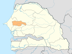
The Diourbel region with the capital Diourbel is a region in the central west of Senegal . Next to the capital city region of Dakar, it is the second smallest region in the country in terms of area and nevertheless the third most populous region in Senegal after this and the neighboring Thiès region to the west . With three quarters of a million inhabitants of the Muslim pilgrimage site of Touba, it comprises the largest settlement in the country outside the capital region.
Geographical location
The Diourbel region is the only region in the country that has neither a portion of the coast nor an external border. It borders, starting from the west clockwise, with the following other regions: Thiès, Louga, Kaffrine and Fatick. Its east-west extent is around 130 km and the north-south extent around 50 km.
The region has no year-round watercourse; the middle course of the Sine , on which the regional prefecture Diourbel lies, only carries water in the rainy season . Nevertheless, the regional groundwater reserves are important.
history
The Diourbel region was one of the seven original regions of Senegal since 1960, but until 1976 also included the territory of the Louga region , which was then created as the eighth region. This reduced the Diourbel region to a fraction of the original area.
This remaining area was the core territory of the Baol Empire , which existed until 1894, including the last few years as a French protectorate. After that, the territory was directly subordinated to the French colonial administration. The region owes a special increase in population to the Great Mosque of Touba , completed in 1963 , which not only attracts crowds of pilgrims every year, but has also led to enormous growth in the town of Touba , which despite its size does not have the legal status of a city (commune) or even one City (Ville) claimed.
Until 2001 the region covered an area of 4359 km². In 2002, the Taïf arrondissement moved from the Fatick region to the eastern Mbacké department of the Diourbel region and enlarged it further east to an area of 4769 km². According to the 2013 census, 1,497,453 inhabitants were documented for the region.
structure
The Diourbel region is divided into three departments:
On the next structural levels, eight arrondissements, three municipalities (Communes) and 37 rural communities (Communautés rurales), 1199 officially recorded villages (Villages) and 768 hamlets (hameaux) are to be named for 2013.
Individual evidence
- ↑ Measure distances with google maps
- ↑ Service Régional de la Statistique et de la Demographie de Diourbel: Situation economique et sociale regional 2013 Area of the region on page 13 of the PDF file 6.07 MB
- ^ Service Régional de la Statistique et de la Démographie de Diourbel: Situation economique et sociale regional 2013. Area and population, page 25
- ^ Service Régional de la Statistique et de la Demographie de Diourbel: Situation economique et sociale regional 2013. Structural levels, page 207
Web links
- Conseil Régional de Diourbel: Plan Régional de Développement Intégré 2008-2012
- Administrative division of the Diourbel region
- Diourbel region near Geonames with marking of the territory until 2001