Rheinhöhenweg
| Rheinhöhenweg | |
|---|---|
 Rheinhöhenweg |
|
| Data | |
| length | a total of 530 km |
| location | left and right of the Rhine on the Middle Rhine |
| Markers | R. |
| Starting point |
Bonn and Bonn-Beuel 50 ° 43 ′ 29.5 ″ N , 7 ° 5 ′ 26.2 ″ E |
| Target point |
Alsheim and Wiesbaden 49 ° 46 ′ 5.4 " N , 8 ° 20 ′ 12.5" E |
| Type | Long-distance hiking trail |
| season | All year round |
The Rheinhöhenweg is a hiking trail along the heights on both sides of the Rhine Valley .
course
The high route with a total length of 530 kilometers leads along both sides of the Rhine from Bonn over the Middle Rhine to the Upper Rhine .
Linksrheinisch the path proceeds with a length of 240 kilometers from Bonn about Andernach , Boppard , Bingen up in the south of Mainz preferred Alsheim , rechtsrheinisch with a length of 272 kilometers from the city of Bonn on the Drachenfels in seven mountains which Loreley and above the Rhinegau to Wiesbaden . Between Lorch and Wiesbaden, the route runs over long stretches over the Taunushauptkamm at an altitude of 400 to 600 meters.
Labelling
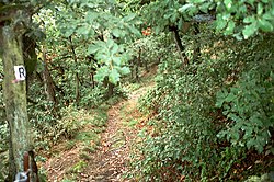
The Rheinhöhenweg is distinguished by a black R on a white background ( R ).
Connecting routes
There are several connecting paths between the Rhine on the left and the right of the Rhine (marked by RV ).
On Rheinhöhenweg are numerous castles and palaces as the Godesburg , Lahneck , castle Stolzenfels , Burg Rheineck , Rheinstein Castle , Dragon Castle .
On the Koblenz-Bingen route, the Rheinhöhenweg crosses the Upper Middle Rhine Valley UNESCO World Heritage Site .
See also
- Rheinsteig - on the right bank of the Rhine
- Rheinburgenweg - left bank of the Rhine
- List of hiking trails in Germany
