Rjukan
| Basic data | |
|---|---|
| Gaustatoppen with Rjukan in the Vestfjord Valley | |
| Fylke : | Telemark |
| Municipality : | Tinn |
| Website : | www.tinn.kommune.no |
| Residents : | 3473 (2006) |
| Postal code : | N 3660 |
| Height : | 303 moh. |
Rjukan is the administrative center of the municipality of Tinn in the province of Vestfold og Telemark in southern Norway , 180 km west of Oslo .
geography
Rjukan is located in the narrow Vestfjord Valley, which is bordered in the north by the southern foothills of the Hardangervidda and in the south by one of Norway's most famous mountains, the Gaustatoppen (1883 m altitude). The narrowness of the east-west valley is the reason why the light of the low-lying sun no longer reaches the place on the valley floor in the winter half-year from October to March - when the Solfest (literally the sun festival ) is celebrated as a greeting , see events below . In 2013, three heliostats (3 mirrors, each with an area of 17 m²) were installed, which during this time reflect sunlight on an area of 600 m² on the market square.
Geographical features are the fjord-like lake Tinnsjø (Norw. "Lake of Tinn" , 434 m depth) located 10 km east of Rjukan and the 105 m high waterfall Rjukanfossen (literally: smoke fall ).
history
The Vestfjord Valley was already a focal point for tourists in the 18th century , who came to see the area's natural attractions, especially Rjukanfossen . Around 1907 around 50 families lived in the valley. Rjukan also owes its actual formation at the beginning of the 20th century to the numerous waterfalls in the immediate vicinity.
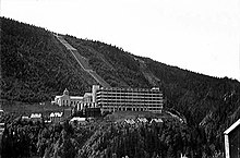
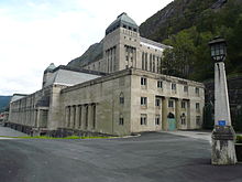
As early as 1909, the place was opened up by the private Rjukanbanen (RjB) and a train ferry across Tinnsjø . This enabled the Vemork hydropower plant ( 59 ° 52 ′ 16.1 ″ N , 8 ° 29 ′ 29 ″ E ) to be built a few kilometers west of Rjukan by Norsk Hydro , whose founder Sam Eyde used the power of Rjukanfossen and other neighboring sources , at the time the largest in the world. In the following years, more power plants (including the Såheim power plant) and industrial facilities were built, and in 1917 there were already around 10,000 people in Rjukan and the surrounding area.
The place and all cultural and social facilities in the valley were built and maintained by the operator of the power plants. For example, in 1928 the Krossobanen , the first cable car in Northern Europe. It was built so that the workers from Rjukan could see the sun even in winter. In the period that followed, Rjukan developed into Norway's first heavy industrial center .
Rjukan became known far beyond Norway's borders during the Second World War . Norwegian researchers had already started researching and producing heavy water (discovered in 1931) at the Vemork chemical and power plant before the war . Heavy water was a necessary tool for nuclear fission and chain reaction .
With the " Operation Weser Exercise " and the occupation of neutral Norway by German troops in April 1940, the research results and the existing stocks of heavy water fell into the hands of the German occupiers after the bitter battle for the Norsk Hydro works . However, shortly before that, France had bought up all the stocks, around 160 kg, which were now stored in Paris (from where they were brought to England before the German army marched there). Production was initially continued.
In order to prevent the possible threat from a German atomic bomb, two Halifax tow planes, each with an Airspeed Horsa cargo ship, took off on the night of 19/20. November 1942 from the Scottish Skitten towards Vemork. Operation Freshman, which was carried out in collaboration with British Royal Engineers , the Special Operations Executive (SOE) and the Norwegian Resistance , aimed to destroy the production and stocks of heavy water. This first airborne operation failed, however, a Halifax and two Horsa gliders crashed into the foothills of the Hardangervidda.
Only one Halifax made the return flight to Scotland. The other survivors were handed over to the Gestapo by the German Wehrmacht and executed on the same day in the surrounding forests. The bloody record of the disastrous commando company was 39 British soldiers shot or killed.
In December 1945, the victims were exhumed and forensic medical examinations to accuse the Gestapo officers . The British soldiers were buried in a soldiers' grave in Helleland's cemetery.
During a second operation in February 1943, Norwegian resistance fighters landed on the Hardangervidda plain and set up their bivouac there. This group managed to blow up most of the tanks in the high concentration facility on February 27th. The larger part of the twelve-member Norwegian group was then able to settle in neutral Sweden , while some resistance fighters maintained a small radio station on the Hardangervidda until the end of the war.
However, the Germans rebuilt the destroyed production areas in the summer of 1943. The Americans then decided to massively bomb the entire facility. On November 16, 140 bombers of the type B-17 "Flying Fortress" attacked the Vemork power station and the research facility. The plant was damaged in the process and the Germans gave up the production of heavy water in Vemork. 21 Norwegian civilians were killed or injured in the 30-minute attack.
After the facility was abandoned in February 1944, the remaining heavy water was to be brought to Germany in railroad cars. To prevent this, the Norwegian resistance fighters took action again.
On February 20, 1944, a three-man Norwegian SOE squad sneaked onto the ferry Hydro , which was supposed to bring the wagons with the barrels across Tinnsjø, and installed an explosive charge in the engine room. When the ferry was about in the middle of the lake, a time fuse detonated the device. The trajectory sank within a few seconds, along with 50 barrels of heavy water (some, not completely filled, remained floating on the surface) and the crew - four German occupation soldiers and 14 Norwegians. A memorial stone (Krigsminne, see picture) on the bank near the sinking point commemorates this day and the loss of people. The whole action was dramatically processed in the British feature film “Heavy Water” ( The Heroes of Telemark , 1965).
The battle for heavy water in Norway ended with a high toll in blood. The actions from mid-1942 to February 1944 were one of the largest coordinated resistance operations in a German-occupied country during the entire war.
After the war, Norsk Hydro's influence in Rjukan waned and its importance as an industrial location declined due to the inaccessibility of the region. However, the power plants remained the main economic factor in the area.
Nowadays, like before the rise to an industrial center, Rjukan is primarily a center for tourism . It is the starting point for tours into the Hardangervidda and a popular ski area in winter .
Buildings and sights
- The church in Rjukan is a cross-shaped structure built in 1915 by architects Berner, Carl & Jørgen. It is made of stone and has 350 seats. The altar panels and the stained glass are by Torvald Moseid . They were built in the course of the restoration of the church (under Asbjørn Stein ) in the years 1965–1968 and were installed in 1968.
- Gaustatoppen - panoramic mountain and ski area
- Gaustabanen - a railway in the Gaustatoppen mountain, built in 1958, used for tourism from 2003
- Rjukanfossen - 105 m high waterfall
- Tinnsjø - a fjord-like lake, 45 km long and up to 434 m deep
- Vemork power station - today an industrial museum with an exhibition on the sabotage activities during World War II (UNESCO World Heritage Site since 2015)
- Krossobanen - Northern Europe's oldest cable car. Built in 1928.
- Tinn Museum - local museum with buildings, furnishings and inventory from 1550 to 1900.
- The mountain mirrors - three mountain mirrors erected in 2013 to provide the community with sunlight in winter (80–100% of sunlight strength).
Sons and daughters of the place
- Gunnar Sønsteby (1918–2012), Norwegian resistance fighter during the German occupation of Norway 1940–1945
- Claus Helberg (1919–2003), participant in the sabotage in Vemork on February 27, 1943
- Knut Haugland (1917–2009) was a Norwegian explorer. Haugland became known as a participant in the "Kon-Tiki Expedition", also a participant in the 1943 sabotage
- Bernt Ivar Eidsvig (* 1953), Augustinian canon and theologian, Catholic priest and since 2005 Bishop of Oslo
- Øystein Mæland (* 1960), Norwegian doctor and politician, police chief 2011–2012
- Jørn Lande (* 1968), rock singer
Events
- Kjerringsveiven - Norway's largest women's hiking day
- Norseman - extreme triathlon over 226 km and 1,800 m difference in altitude
- Solfest - with this festival the residents of Rjukan celebrate the return of sunlight to the valley every year. Carnival in Norwegian
- FIS Telemark World Cup
Web links and individual references
- ↑ Spiegel over Norwegian mountain village: It is getting light in Rjukan. In: Spiegel Online . July 18, 2013, accessed January 15, 2016 .
- ↑ Norwegian village finally sees the sun even in winter - news.ORF.at. In: orf.at. October 30, 2013, accessed January 15, 2016 .
- ↑ Information from Visitnorway
- ↑ Homepage of the Vemork power plant (Norwegian and English)
- ↑ Hjem - Kjerringsveiven. In: kjerringsveiven.no. Retrieved January 15, 2016 (Norwegian Bokmål).
- ↑ Isklar Norseman Xtreme Triathlon - Simply the ultimate triathlon on planet earth. In: nxtri.com. Retrieved January 15, 2016 .
Coordinates: 59 ° 53 ' N , 8 ° 36' E


