
Rogers Dry Lake
| Rogers Dry Lake | ||
|---|---|---|
_%E2%80%93_satellite_image.jpg)
|
||
| Rosamond Lake (bottom left) and Rogers Dry Lake (right) in California's Mojave Desert | ||
| Geographical location | Mojave Desert ; Kern County , California (USA) | |
| Tributaries | without | |
| Drain | without | |
| Location close to the shore | Lancaster , Palmdale , California City , Mojave | |
| Data | ||
| Coordinates | 34 ° 55 '19 " N , 117 ° 49' 39" W | |
|
||
| Altitude above sea level | 694 m | |
| surface | 114 km² | |

The drainless salt flat Rogers Dry Lake (also Rogers Lake , Muroc Dry Lake ) is located in the Mojave Desert in Kern County , California , around 160 kilometers northeast of Los Angeles . The name is derived from a translation of the Spanish "Rodriguez" into English .
The lake formed in the Pleistocene is one of the lowest places in the remote Antelope Valley and has a flat surface that has been polished smooth by weather influences. That's why US government agencies use it as a test site for the aerospace industry. The lake owes its classification as a National Historic Landmark to this use .
geology
The lake was formed in the Pleistocene and, with today's Rosamond Lake and Buckhorn Dry Lake, formed a unit that was constantly filled with water and dried out in the Holocene .
At only around 694 meters above sea level, the approximately 114 square kilometer, extremely flat area is one of the lowest places in the Antelope Valley. The dried-out surface is polished again and again when the winds brush the water from winter rains over the clay and silt , so that it appears as smooth as glass. From the surrounding hills as well as the San Gabriel Mountains in the south and Tehachapi Mountains in the west, snow or water occasionally collects in the bare salt flat.
use
The mostly dried up salt lake was first used by the US military as a test site in 1933 , at that time for bomb tests. Today, maintains Edwards Air Force Base , an air base of the United States Air Force , which the NASA Research Center Dryden is affiliated, in Rogers Dry Lake several unpaved runways , one of which (number 17/35) measures over 12 kilometers, thus considered the longest in the world. Because of its remote location and because the hard, absolutely flat surface of the salt flats is a natural extension of the runways, the area is an ideal test site for aerospace. For example, in 1977 the first attempts to land the space shuttle, which is still in development, were made there and in 1984 a crash test was carried out with a Boeing 720 . The site also served as an alternate airport for space shuttle landings. To make orientation easier for pilots, a compass rose of enormous dimensions was drawn on the ground , with a diameter of 1.22 kilometers it is the largest of all.
Because of its importance to the developments in the aerospace industry, Rogers Dry Lake was classified as a National Historic Landmark in 1985.
gallery

During short periods of rain, water gathers in Rogers Lake.
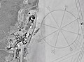
Satellite photo of the world's largest compass rose on the bottom of Rogers Dry Lake

Runway 5R / 23L at Edwards Air Force Base


Web links
- The Dry Lakes - Description of the Dryden Flight Research Center (English)
Individual evidence
- ↑ Rogers Lake. In: Geographic Names Information System . Retrieved May 20, 2010 .
- ↑ a b c Edwards' History. (No longer available online.) In: Edwards Air Force Base website . Archived from the original on November 4, 2010 ; accessed on May 20, 2010 (English). Info: The archive link was inserted automatically and has not yet been checked. Please check the original and archive link according to the instructions and then remove this notice.
- ^ Anthony R. Orme: Lake Thompson, Mojave Desert, California: The late Pleistocene lake system and its Holocene desiccation . In: Robert Hershler, David M. Miller, Marith C. Reheis (Eds.): Late Cenozoic drainage history of the southwestern Great Basin and Lower Colorado River Region: Geologic and Biotopic Perspectives . Geological Society of America, 2008, ISBN 978-0-8137-2439-3 , pp. 261 ( limited preview in Google Book Search [accessed May 20, 2010]).
- ↑ a b The Dry Lakes. NASA , accessed May 20, 2010 .
- ^ Rogers Dry Lake. National Park Service , accessed May 20, 2010 .
- ↑ David Blatner: So you come up and down again . Campus Verlag, 2003, ISBN 978-3-593-37314-0 , pp. 124 ( limited preview in Google Book Search [accessed May 20, 2010]).
- ↑ NASA's Dryden Flight Research Center is situated immediately adjacent to the compass rose on the bed of Rogers Dry Lake at Edwards Air Force Base, Calif. NASA , accessed May 20, 2010 .
- ↑ The largest compass rose in the world. Retrieved May 20, 2010 .
- ↑ Listing of National Historic Landmarks by State: California. National Park Service , accessed August 3, 2019.