Rothenseer connecting canal
| Rothenseer connecting canal | |
|---|---|
| abbreviation | RVK |
| location |
|
| length | 5.34 |
| Built | 1938 |
| Expanded | 2000 to 2014 |
| class | V |
| Beginning | Mittelland Canal |
| The End | Elbe |
| Descent structures | 2 locks and a lift |
| Ports | Harbor Separation Dam |
| Junctions, crossings | Magdeburg branch canal |
| Used river | Elbe |
| Outstanding structures | Rothensee boat lift |
| Information center, museum | Visitor platform at the Rothensee lock |
| Responsible WSD | General Directorate for Waterways and Shipping - Branch Office East- |
| Waterways and Shipping Office Magdeburg | |
| Low water lock in the direction of the Elbe | |
The Rothenseer Connection Canal (RVK) is a federal waterway of waterway class Vb in the state of Saxony-Anhalt , for which the Magdeburg Waterways and Shipping Office is responsible. It creates a connection between the Mittelland Canal and the Elbe and is 5.34 kilometers long (new kilometers 2010). The canal is used by shipping to descend from the Mittelland Canal to the Elbe and to enter the Magdeburg branch canal with the port basins I and II.
Route
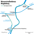
The Rothensee descent canal , which went into operation in 1938, branches off from the Mittelland Canal at km 319.95 and leads to the Rothensee ship lift , which was closed from 2006 to 2013 but is now back in operation. As part of the traffic project German Unity No. 17, a new junction at MLK-km 319.59 for the Rothensee lock was created to the west of it in 1997-2001 , in order to enable traffic with large motor freight ships and push convoys . The new canal section meets the previous canal at km 1.27 in the underwater area of the elevator. The Rothenseer connecting canal is now the new canal section with the lock and the subsequent canal stretch up to the confluence with the Elbe with km 5.53 at Elbe-km 333.55. The Magdeburg branch canal branches off with the harbors at the Separation Dam at km 3.96. In addition, there is the first (old) trip with the boat lift with a length of 880 m.
Locks
The Rothensee Sparschleuse, which was opened to traffic in 2001 at km 0.65, has 3 open fuel-saving basins offset in height, a useful length of 190 m and a width of 12.50 m. The height of fall is between around 11 and 18 m depending on the water level of the Elbe; it will decrease when the lock at the end of the canal is finished.
The Magdeburg low water lock , the port lock, was built and put into operation at the end of 2013 in order to create sufficient water levels in the Rothensee connecting canal and in the adjoining port area, regardless of the Elbe low water periods . It is located at 4.76 km of the canal, has a passage width of 25 m and is 215 m long including its head. The lock only works when the water level in the Elbe is low. With the help of a pumping station, the water level in the port area at Elbeniedrigwasser is regulated so that the ships can operate all year round at full diving depth.
bridges
A total of three bridges cross the canal. These include the sluice bridge at kilometer 0.78 over the lower head of the Rothensee sluice gate, the bridge on federal highway 2 at kilometer 1.67 and the Rothensee-Glindenberg road bridge at 1.87 kilometer of the waterway.
map
literature
- Hans-Joachim Uhlemann: Berlin and the Märkische waterways. transpress publishing house for transport, Berlin 1987, ISBN 3-344-00115-9 .
- Writings of the Association for European Inland Shipping and Waterways e. V. WESKA (Western European Shipping and Harbor Calendar), Binnenschifffahrts-Verlag, Duisburg-Ruhrort. OCLC 48960431
- Wasserstraßenkreuz Magdeburg, documentation for traffic clearance October 10, 2003
Web links
Individual evidence
- ↑ Directory E, serial no. 33 der Chronik ( Memento of the original from July 22, 2016 in the Internet Archive ) Info: The archive link was automatically inserted and has not yet been checked. Please check the original and archive link according to the instructions and then remove this notice. , Federal Waterways and Shipping Administration (PDF file)
- ↑ a b c Lengths (in km) of the main shipping routes (main routes and certain secondary routes) of the federal inland waterways ( memento of the original from January 21, 2016 in the Internet Archive ) Info: The archive link was automatically inserted and not yet checked. Please check the original and archive link according to the instructions and then remove this notice. , Federal Waterways and Shipping Administration
Coordinates: 52 ° 13 '26.4 " N , 11 ° 40' 8.6" E


