
Süntel
| Süntel | |
|---|---|
 |
|
| Highest peak | Hohe Egge ( 440 m above sea level ) |
| location | Lower Saxony |
| Coordinates | 52 ° 12 ′ N , 9 ° 21 ′ E |
| particularities | Most pronounced layer level in the Lower Saxony mountainous region |


The Süntel is a good 440 m above sea level. NHN high low mountain range in the Calenberger Bergland (part of the Weser Uplands ) in Lower Saxony southwest of Hanover , north of Hameln and west of Bad Münder .
geography
The Süntel is one of the typical compact mountain ranges of the Weser Uplands, which, in addition to narrow layered ridges, give this landscape its character. At a distance of around 15 kilometers north of the city of Hameln, the Süntel extends from northwest to southeast over about 12 km as an eastern continuation of the Weser Mountains and is surrounded by the Auetal in the north, the Deister-Süntel valley in the northeast and the upper Weser valley in the southwest . The highest elevation is in the southeast with the gently rising double summit of the Hohen Egge . In the middle part of the Süntel is a stratification of winding, south-west facing valleys , a rather rare mountain form in the Leine and Weser Uplands (next to Osterwald , southern Deister and the Seven Mountains ). Here long, vertical, and on the Hohenstein up to 60 m high wall lines characterize the landscape, as well as numerous special features such as waterfalls, landslides, ravine-like notches, crevices and caves. At the Rohden pass , the Süntel merges westward into the narrow chain of peaks of the Weser Mountains.
The Süntel belongs to the Weserbergland Schaumburg-Hameln nature park . The Hohenstein with its immediate surroundings is a nature reserve , which is prohibited from entering above the highest cliffs.
In older times the name Süntel was also officially used for a larger area that extends from the Wiehengebirge over the Wesergebirge to the Süntel. From a geomorphological point of view, too, it is not unreasonable to treat these parts as a unit.
geology
General
The southeastern part of the Süntel with the Hohen Egge consists mainly of Wealden sandstones from the Lower Cretaceous with little bituminous coal deposits. The north-western area with the Hohenstein and its 350 m long and 50 to 60 m high cliff face consists of limestone from the Upper Jura , the coral ole lite . The lower slopes consist of unstable Heersumer layers that are largely covered by gravel from the inland ice of the Saale Ice Age .
particularities
Geological features of the Süntels are:
- Riesenberghöhle near Langenfeld, the largest stalactite cave in Lower Saxony
- Schillat Cave , open to visitors as a show cave
- At the head of the rocky Höllengrund valley, the two highest natural waterfalls in Lower Saxony at the Höllenmühle near Langenfeld ( see also : List of waterfalls in Germany )
- Hohenstein Plateau north of Hessisch Oldendorf with rock faces and a deep crevasse system.
history
- The Dachtelfeld , a plateau over 100 hectares in size and up to 350 m high , is historically interesting . Insurgent Saxons destroyed part of the Frankish occupation troops here in 782 in the Battle of the Süntel , which was avenged by Charlemagne in the same year by the blood court of Verden .
- The Hohenstein is an old Germanic cult site , which was dedicated to the god Donar . Numerous old legends entwine around this mountain and its ledges, the Hirschsprung, the Green Altar and the Devil's Pulpit .
- On the Amelungsberg you can find the remains of the prehistoric to medieval ramparts Amelungsburg and a stone age stone grave .
- Above Rohden is the castle stables of Roden Castle .
- There are traces of coal mining in the southeastern part of the Süntel near Bad Münder from the more recent past .
- Between 1933 and 1938 the Horst Wessel memorial was commissioned by the city of Hameln .
- In the Süntel there was a US radar station on the Hohen Egge and a NATO depot near Hülsede.
Say
Like many other forest areas, there are numerous legends for the Süntel. One of the most famous is the legend of the Baxmann , according to which the villain is still at the Baxmann spring near the Baxmann shack, where he was banished to scoop up the spring with a thimble.
Flora and fauna

The Süntel is a mixed beech forest in which it alongside the dominant beech are many other tree species such as oak , fir , hornbeam and Douglas fir as well as rare as yew and serviceberry . A botanical rarity are the dwarf beech is, of which there are still nearly one in Süntel (Dachtelfeld and Bleeksgrund) dozen are older copies. The last large beech forest on the Westeregge was almost completely cleared in 1843. In addition, you can find numerous types of flowers that have become rare, such as cowslips , spring flowers , horseshoe clover , deer-tongue fern , striped fern , lady's slipper and spotted orchid etc.
In addition to deer and wild boar are also in Süntel mouflon . The barn owl , kestrel , black woodpecker and marten appear rarely . The black stork is occasionally seen on the southern slope .
Economy and tourism
In addition to the forestry and tourism taking in Süntel rock mining an important position.
The Süntelsandstein was used for many well-known buildings in the area, such as B. at the Pied Piper House in Hameln , Barntrup Castle, Schwöbber Castle and Hämelschenburg Castle . The limestone from quarries near Pötzen, Segelhorst , Langenfeld and Hamelspringe is used for road construction.
The city of Münder operated coal mining in the Süntel for about half a century from 1809 .
In the Süntel there are hiking trails with views of the valleys as well as long straight, somewhat monotonous farm roads without signage. The Hohensteinfelsen serves as a training ground for climbers and alpinists .
In Hülsede there is a ski lift on the Kehen Brink.

View of the Deister from the Hohen Egge

Sandstone from the Süntel
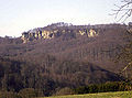
The Hohenstein in the Süntel

The Süntelturm on the Hohen Egge
Way to the Süntelturm
_IMG_2825.jpg)
_IMG_2832.jpg)

_IMG_2812.jpg)
_IMG_2809.jpg)
mountains and valleys
mountains
Mountains and elevations of the Süntel are - with a height in meters above sea level (NHN):
- Hohe Egge (approx. 440 m) with Süntelturm (south) and transmission mast (north, 435.2 m); in the Süntel center
- Bakeder Berg (about 375 m); southwest of Bakede
- Hoher Nacken (or: Hohenacken; about 375 m); northeast of Pötzen
- Dachtelfeld (356.0 m); in the Süntel center
- Cat nose (352.7 m); northeast of Hessisch Oldendorf-Haddessen
- Südwehe (about 350 m)
- Hohenstein (340.5 m); with “Green Altar”, “Teufelskanzel”, “Hirschsprung” and “Kreuzstein” nearby; between Langenfeld and Zersen
- Amelungsberg (about 325 m); northeast of Segelhorst
- Borberg (approx. 320 m), with the Roter Stein rock cliff; north-northeast of Hessisch Oldendorf-Bensen
- Ramsnacken (approx. 320 m), with "Moosköpfklippen"; southwest of Langenfeld
- Riesenberg (about 310 m), with a quarry; south of Langenfeld
- Schrabstein ("Schrabst", 300.2 m); between Rohdental and Langenfeld
- Iberg (about 300 m); between Auetal-Rannenberg and Hessisch Oldendorf-Langenfeld
- Moss heads (about 300 m); southeast of Langenfeld
- Mittelberg (297.0 m); north of Hessisch-Oldendorf-Barksen
- Mattenberg (288.6 m); west of Hamelspringe
- Hasseln (286.5 m)
- Osterberg (260.1 m); northeast of Hessisch Oldendorf-Bensen
- Hünenburg (251.7 m); between Rohdental and Rannenberg
- Westerberg (249.2 m); north of Hessisch Oldendorf-Bensen
- Baumgartenberg (232.1 m); north of Hessisch Oldendorf-Segelhorst
- Hülsebrink (227.2 m); north of Klein Süntel
- Wendgeberg (or: "Wenchenberg", about 223 m), north-northeast of Hessisch Oldendorf-Zersens
Valleys
The valleys of the Süntel include:
- Bleeksgrund
- Hell bottom
- Long Föhrtal
- Snow bed
- Dead Valley
- Wellergrund
- Fischertal
Localities
Municipalities and cities on the Süntel are:
- municipality Auetal
- Hülsede municipality
- City of Bad Münder am Deister
- City of Hessisch Oldendorf
- City of Hameln
Restaurants

The forest restaurants in and on the Süntel include:
- Bergschmiede, near Bad Münder am Deister
- Süntelturm on the Hohen Egge, near Bad Münder am Deister
- Paper mill at Zersen
- Baxmann-Baude, near Zersen
- Weinschänke, in Rohdental
literature
- Fritz Holstein: The statute of the Süntelwaldgenossenschaft Bensen. Forest management of the Süntelwald . O. J.
- Christoph Kaiser: Introduction to the geology of the Hohenstein nature reserve . Ed .: Lower Saxony State Forest Administration, State. Oldendorf Forestry Office, Hessisch-Oldendorf 1979
- Helga Knoke: Forest and Settlement in the Süntel . Schaumburger Studies, No. 22. Verlag C. Bösendahl, Rinteln 1968
- Friedrich Kölling: The Süntelwaldgenossenschaft. A contribution to the legal and economic history of a Schaumburg brand cooperative. Rinteln (Weser): Bösendahl 1962.
- Martin Scheide: The hunt in the Süntel . Schaumburger Heimathefte, No. 10. Verlag C. Bösendahl, Rinteln 1962
Web links
Individual evidence
- ↑ Map services of the Federal Agency for Nature Conservation ( information )
- ↑ "(...) Weser and Wiehengebirge were then [in the year 991] still called Süntel" . Cf. Rüthing, Heinrich: The beginnings of religious life on the Wittekindsberg according to the written sources, p. 45 here .
- ^ Geological map of Lower Saxony, sheet 2018 Kathrinhagen