
Sahlenburg
|
Sahlenburg
Sahlenborg ( Low German ) City of Cuxhaven
|
||
|---|---|---|
 |
||
| Height : | 5 m above sea level NHN | |
| Area : | 9.39 km² | |
| Residents : | 2951 (May 19, 2018) | |
| Population density : | 314 inhabitants / km² | |
| Incorporation : | June 1, 1970 | |
| Postal code : | 27476 | |
| Area code : | 04721 | |
Location of Sahlenburg in Lower Saxony |
||
 Sahlenburg in the city of Cuxhaven
|
||

Sahlenburg ( Low German Sahlenborg ) is a district of the city of Cuxhaven and a resort on the North Sea coast of Lower Saxony . Sahlenburg is one of the tourist centers in Cuxland .
geography
| You | Stickenbüttel | |
.svg)
|
||
| Berensch-Arensch | Holte braces |
(Source:)
history
At 18,000 BC The first finds of flint tools by ice age reindeer hunters in Sahlenburg's Pennworthmoor are dated. In 1325 the Sahlenburg of the Lords of Lappe , a noble family, was first mentioned in a document. Around 1400 the landlords moved their residence to a stone castle in Ritzebüttel . This building is considered to be the forerunner of Ritzebüttel Castle . There is still no reliable explanation for the place name "Sahlenburg".
The communities Arensch , Berensch , Cuxhaven, Döse , Duhnen, Groden , Gudendorf , Holte , Insel Neuwerk , Oxstedt , Ritzebüttel , Sahlenburg, Spangen , Stickenbüttel, Süder- and Westerwisch belonged to the Hamburg office of Ritzebüttel until 1864 and then to the Ritzebüttel estate . In 1871, with the introduction of the Hamburg municipal code, Sahlenburg had its own municipal council.
In September 1906, the first German maritime hospital was opened on a heather plot of around 35 hectares. It was built by the Nordheim Foundation . The Mathilde Emden House from 1914 was donated by the Hamburg merchant Mathilde Emden . The Helios-Seehospital Sahlenburg has been operating the facility since 2006.
In 1926 the municipalities of Arensch, Berensch, Duhnen, Groden, Gudendorf, Holte, Insel Neuwerk, Oxstedt, Sahlenburg, Spangen, Stickenbüttel, Süder- and Westerwisch became part of the Hamburg rulership. With the Greater Hamburg Act from 1 April 1937 were the municipalities Arensch, Berensch, Gudendorf, Oxstedt, Sahlenburg, Holte and bracelets on the county Hadeln , district of Stade of the Prussian province of Hannover . The Johannes Church was consecrated in 1939 .
Sahlenburg was the location of a coastal radio station .
Incorporations
Sahlenburg was incorporated into the city of Cuxhaven on June 1, 1970 .
Population development
|
|

|
politics
Local council
The local council of Sahlenburg consists of two councilors and seven councilors from the following parties:
- CDU : 5 seats
- SPD : 2 seats
- FDP : 1 seat
- The Cuxhaveners : 1 seat
(Status: local election September 11, 2016)
Local mayor
The local mayor of Sahlenburg is Herbert Kihm (CDU). His deputy is Claudia Bönnen (CDU).
coat of arms
|
|
Blazon : “ Wave divided by blue and silver ; above: a silver flying gull ; below: a red battlement wall . " |
| Justification of the coat of arms: The seagull symbolizes the location of the place on the North Sea, as do the waves; both indicate the character of the place as a seaside resort. The battlements are reminiscent of the final syllable in the place name. |
Town twinning
-
 Theix , municipality in France, since 1995
Culture and sights
Buildings
- Johannes Church from 1939 (Nordheimstraße 26)
- New Apostolic Church (Spanger Strasse 24)
- Helios Seehospital (Nordheimstrasse 201)
Photo gallery

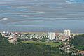 Sahlenburg 2012
 View over the mudflats
to Neuwerk High-rise buildings in Sahlenburg
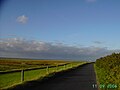 Hiking trail to Duhnen by the sea
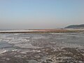 Watt in Sahlenburg in winter


Economy and Infrastructure
Companies
Like Döse, Sahlenburg is a family seaside resort , as the prices are generally lower here than in Duhnen, for example . The Sahlenburg beach and the forest swimming pool are popular with tourists. In addition to the opportunity to swim in the sea at high tide, there are also walks to the Duhner Heide and the Wernerwald , in which the Finkenmoor nature reserve is located, as well as to Duhnen and the island of Neuwerk . Horse-drawn carriages, the so-called Watt wagons, drive to Neuwerk every day . Sahlenburg is characterized by two large campsites. In addition, two high-rise buildings can be seen from a great distance.
education
The Sahlenburg elementary school is located in Sahlenburg.
traffic
Large parts of Sahlenburg are traffic-calmed. There are large public parking spaces for day visitors on Hans-Retzlaff-Straße. There are other public parking spaces along Wernerwaldstrasse and Oskar-von-Brock-Strasse. The public transport connects the district with the train station Cuxhaven (ZOB).
Personalities
People connected to the place
- Marcus Nordheim (1812–1899), Jewish merchant, the Nordheim Foundation was brought into being by his executors and it built the Seehospital, a street in Sahlenburg commemorates the merchant (Nordheimstrasse)
- August Jauch (1848–1930), Holstein landlord and Hamburg politician, was on the board of the Nordheim Foundation in Sahlenburg
- Hugo Groothoff (1851–1918), architect, built the Seehospital
- Karl Waller (1892–1963), teacher and homeland and prehistory researcher of the Elbe-Weser area, cultural curator of the city of Cuxhaven, excavations and emergency rescues and the like took place under his direction. a. held in Sahlenburg
- Rudolf Robbert (* 1947), politician (SPD), was a member of the Sahlenburg local council
Web links
Individual evidence
- ↑ a b c Federal Statistical Office Wiesbaden (ed.): Official municipality register for the Federal Republic of Germany - 1957 edition (population and territorial status September 25, 1956, for Saarland December 31, 1956) . W. Kohlhammer, Stuttgart 1958, p. 188 ( digitized version ).
- ^ A b Heike Leuschner: The districts at a glance. Twelve in one go . In: Nordsee-Zeitung . May 19, 2018, p. 31 .
- ↑ Cuxhaven receives status as a resort. In: Website Nds. Ministry of Economy, Labor, Transport and Digitization. August 15, 2013, accessed July 13, 2018 .
- ↑ Overview map of the Cuxhaven district. In: cuxland-gis.landkreis-cuxhaven.de. November 2016, accessed June 14, 2020 .
- ^ A. Dehlinger: Law on Greater Hamburg and other territorial adjustments (RGBl. 1937 I, Art. 1, p. 91). In: www.verfassungen.de. January 26, 1937, archived from the original on February 1, 2014 ; accessed on July 13, 2018 .
- ↑ a b Statistical Bureau of the Tax Deputation (ed.): The city of Hamburg, the suburbs, municipalities, localities and independently named areas of the Hamburg state . Otto Meissner Verlag, Hamburg 1875, p. 81 ( digitized in Google Book Search [accessed June 14, 2020]).
- ^ Ulrich Schubert: Municipal directory Germany 1900 - Landherrenschaft Ritzebüttel. Information from December 1, 1910. In: gemeindeververzeichnis.de. January 5, 2020, accessed June 14, 2020 .
- ^ A b c Michael Rademacher: German administrative history from the unification of the empire in 1871 to the reunification in 1990. Landkreis Land Hadeln ( see under: No. 48 ). (Online material for the dissertation, Osnabrück 2006).
- ↑ Sahlenburg. In: Website Stadtwiki Cuxhaven. Retrieved July 8, 2019 .
- ↑ a b Sahlenburg local council. In: Website City of Cuxhaven. Retrieved August 7, 2017 .
- ^ Rudolf Lembcke: Land Hadeln district. Past and present . Ed .: District of Hadeln. Buchdruckerei Günter Hottendorff, Otterndorf 1976, p. 60 (coat of arms).
- ↑ Partners / sponsorships. In: Website City of Cuxhaven. Retrieved December 19, 2013 .
Altenbruch | Altenwalde (with Franzenburg , Gudendorf and Oxstedt ) | Berensch-Arensch (with Arensch and Berensch ) | Cuxhaven | Doze | Duhnen | Groden | Holte braces | Lüdingworth | Sahlenburg | Stickenbüttel | Süderwisch-Westerwisch