
Schönfeld / Schullwitz
 with Borsberg, Eschdorf, Krieschendorf, Malschendorf, Reitzendorf, Rossendorf and Zaschendorf Statistical district No. 47 of Dresden |
|
|---|---|
  |
|
| Coordinates | 51 ° 2 '0 " N , 13 ° 54' 23" E |
| height | 175- 383 m above sea level. NN |
| surface | 26.97 km² |
| Residents | 3332 (Dec. 31, 2017) |
| Population density | 124 inhabitants / km² |
| Incorporation | 1999 |
| Post Code | 01328 |
| prefix | 0351 |
| Website | www.dresden.de (PDF; 345 kB) |
| structure | |
| Locality | Schönfeld-Weißig |
| Districts |
Borsberg , Eschdorf , Krieschendorf , Malschendorf , Reitzendorf , Rossendorf , Schönfeld , Schullwitz , Zaschendorf |
| Transport links | |
| Federal road |
|
| bus | 98B, 98C, 226, 228, 229, 261 |
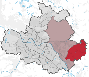
Schönfeld / Schullwitz with Borsberg, Eschdorf, Krieschendorf, Malschendorf, Reitzendorf, Rossendorf and Zaschendorf is a statistical district in the far east of Dresden . The long district name results from the stringing together of nine rather poorly populated districts of the village of Schönfeld-Weißig , which are statistically recorded in this unit.
It is the largest and easternmost inhabited statistical district of Dresden and contains nine villages in the Schönfeld highlands . The Helmholtz Center Dresden-Rossendorf and the Triebenberg laboratory of the TU Dresden are located in Schönfeld / Schullwitz .
structure
This statistical district includes the Schönfeld-Weißiger districts of Borsberg , Eschdorf (with raisin village ), Krieschendorf , Malschendorf , Reitzendorf , Rossendorf , Schönfeld , Schullwitz and Zaschendorf . Schönfeld / Schullwitz is the largest inhabited statistical district in terms of area in Dresden, but it is sparsely populated and, despite the large number of districts, due to its village-rural character, it is also the one with the lowest population density. It is divided into the following eight statistical districts :
- 471 Schönfeld
- 472 Schullwitz
- 473 Borsberg
- 474 Eschdorf
- 475 Rossendorf
- 476 Krieschendorf / Malschendorf
- 477 Reitzendorf
- 478 Zaschendorf
location
Schönfeld / Schullwitz borders on the statistical districts of Hosterwitz / Pillnitz , Gönnsdorf / Pappritz and Weißig . Neighboring northeast to southeast are Radeberg , Dürrröhrsdorf-Dittersbach and Pirna .
The boundaries of the statistical district follow the old corridor boundaries of the villages through the Keppgrund , the Schönfeld highlands or the southern Radeberger Land and along the Dresden Elbe slopes . In the east they are also identical to the Dresden city limits. Schönfeld / Schullwitz lies completely outside the Elbe valley . The Triebenberg is the highest point in the Saxon capital.
traffic
Main streets of are the national highway 6 and the state road 177 that intersect in Rossendorf and the city center or to the highways A 4 and A 17 lead. They are used by various regional bus routes from Dresden and Müller Busreisen , which connect Schönfeld / Schullwitz with Stolpen , Sebnitz , Dresden city center and Bühlau , among others .
Web links
- Statistical district of Schönfeld / Schullwitz (PDF; 345 kB)
Statistical districts: Äußere Neustadt (Antonstadt) | Albertstadt | Bubble joke | Briesnitz | Bühlau / White Deer | Coschütz / Gittersee | Cossebaude / Mobschatz / Oberwartha | Cotta | Airport / industrial area Klotzsche | Friedrichstadt | Gönnsdorf / Pappritz | Gompitz / Old Franconia | Gorbitz-Nord / Neuomsewitz | Gorbitz-East | Gorbitz-Süd | Großzschachwitz | Gruna | Dresden Heath | Hellerau / Wilschdorf | Hellerberge | Hosterwitz / Pillnitz | Inner old town | Inner New Town | Johannstadt-North | Johannstadt-Süd | Kaditz | Kleinpestitz / Mockritz | Kleinzschachwitz | Klotzsche | Langebrück / Schönborn | Leaf guest | Leipzig suburb | Leuben | Leubnitz-Neuostra | Lockwitz | Löbtau-Nord | Löbtau-Süd | Loschwitz / Wachwitz | Mickten | Naußlitz | Niedersedlitz | Pieschen-Nord / Trachenberge | Pieschen-Süd | Pirnaische Vorstadt | Plauen | Prohlis-North | Prohlis-South | Radeberger Vorstadt | Räcknitz / Zschertnitz | Reick | Schönfeld / Schullwitz | Seervorstadt-Ost / Great Garden | Seidnitz / Dobritz | Chasing | Striesen-Ost | Striesen-Süd | Striesen-West | Südvorstadt-Ost | Südvorstadt-West | Tolkewitz / Seidnitz-Nord | Trachau | Weixdorf | Whitish | Wilsdruffer Vorstadt / Seevorstadt-West