Schützenstrasse (Düren)
The Protect road in the district town Düren ( Nordrhein-Westfalen ) is an ancient city road . It runs outside the former city wall parallel to this city fortification .
Schützenstraße connects Kölnstraße in a northerly direction with Bismarckstraße .
In the street you can see some listed buildings:
- the roundabout
- the kiosk from the 1950s
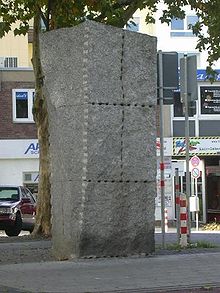
In the middle of the street there is a Rückriem stele . This modern monument commemorates the synagogue that was inaugurated on May 24, 1872 and stood opposite. It was completely destroyed in the November pogroms on November 10, 1938 (called Reichskristallnacht by the National Socialists ) and was never rebuilt. It was to the right of today's parking garage. At the confluence with Bismarckstrasse are the branches of the Kaufhof and the former Dürener Bank , now Commerzbank
history
Schützenstrasse was laid out on the leveled city ramparts. From around 1800 it was called "Köln-Obertor-Promenade". The drained city moats were left to the riflemen . The St. Ewaldus Rifle Guild of 1486 held their target practice here. It was not until 1862 that the shooting range was relocated to Großtivoli (today Willy-Brandt-Park). See the shooting range in Willy-Brandt-Park .
After the deliberations of the city council on May 7, 1889, the street with the long name should be called Frankenstrasse . However, a corresponding decision was not made. Instead, the city council decided on July 31, 1896 to rename it to Schützenstrasse .
See also
swell
- List of streets on the website of the city of Düren (PDF; 58 kB)
- Josef Geuenich: The Düren street names , Düren 1965, published by the city of Düren and the Düren history association
Coordinates: 50 ° 48 ′ 15.7 ″ N , 6 ° 29 ′ 7.7 ″ E


