
Schanze (Schmallenberg)
|
Jump
City of Schmallenberg
Coordinates: 51 ° 7 ′ 50 ″ N , 8 ° 22 ′ 28 ″ E
|
||
|---|---|---|
| Height : | 715.9 (680-732) m above sea level NHN | |
| Residents : | 42 (Dec. 31, 2019) | |
| Postal code : | 57392 | |
Location of Schanze in Schmallenberg |
||
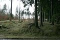
 Aerial photo (2013) with chapel and ski lift
|
||


Schanze is a district of the town of Schmallenberg in the North Rhine-Westphalian Hochsauerlandkreis .
geography
location
Schanze is located a little west of the crest of the Rotkaarkamm, the main ridge of the Rothaargebirge , in the Sauerland-Rothaargebirge Nature Park . It is located 6.5 km southeast of the Schmallenberg core city and 3.7 km southeast of the Schmallenberg district Grafschaft at 680 to 732 m above sea level. NHN ; the town center is 715.9 m above sea level.
Neighborhoods
Neighborhoods of Schanze are: Oberkirchen and Lüttmecke in the north, Vorwald in the northeast, Girkhausen (beyond the Rotkaarkamm) in the east-southeast, Kühhude in the southeast, Latrop in the southwest, Grafschaft in the west-northwest and Almert in the northwest.
history
The name Schanze comes from the medieval Landwehr road barrier , which in 1737 was called the "Langenscheider Schantz". Landguards usually consisted of a simple trench behind which there was an earth wall created from the trench excavation. A hedge was planted on the wall, which was snapped off at man's height. The kinked branches were braided and stuck in the ground to be knocked out again. This created an impenetrable living hedge. Hence the name Knick or Gnick for a Landwehr. Landguards played a role as border fortifications of certain legal districts.
The earth walls of the road barrier at Schanze, which is designated as a cultural monument, were used to control a route from the Sauerland in the Electorate of Cologne to Siegen / Nassau. Parts of it are still there today. The ski jump reached from the steep Siepen of the Grubental over the hilltop into the opposite valley of the Hartmecke. Another ski jump is located below the village from Siepen der Latrop over the hilltop to Siepen der Grafschaft. An old field name above Schanze, Bauernschlag , still reminds of the border crossing with a turnpike. The fortification has given its name to the newly created place in the area of the "Uelmke" desert.
Until the local reorganization, Schanze belonged to the county of Grafschaft. Since January 1st, 1975 it has been part of the town of Schmallenberg.
Until the 20th century, the residents of Schanze (at that time also called "Ulmecke") lived from agriculture and coal-burning. Today the hamlet is a well-known hiking and winter sports destination.
Sights and leisure
The listed former forester's house in Schanze is well worth seeing. The hamlet is located on the Talvariante the Rothaarsteig and the Waldskulpturenweg ; The Kyrillpfad Schanze is attached to the latter and is intended to illustrate the destruction of the forest by Hurricane Kyrill (2007). West of Schanze there is a 550 m long anchor lift with a ski slope. Around the hamlet there is an extensive and natural network of trails with a total of 38 km of cross-country trails; four trails with different levels of difficulty are groomed for beginners and professionals.

Sculpture crook on the forest sculpture trail near Schanze
Road barrier : medieval Landwehr ; Earth walls above Schanze

Ski lift (aerial view)

Viewing platform on the Kyrillpfad

Vegetation 10 years after Kyrill


.jpg)

Individual evidence
- ↑ Population figures Schmallenberg 2019 , accessed on July 2, 2020
- ↑ Topographical Information Management, Cologne District Government, Department GEObasis NRW ( Notes )
- ^ Federal Statistical Office (ed.): Historical municipality directory for the Federal Republic of Germany. Name, border and key number changes in municipalities, counties and administrative districts from May 27, 1970 to December 31, 1982 . W. Kohlhammer, Stuttgart / Mainz 1983, ISBN 3-17-003263-1 , p. 335 f .
- ↑ Der Kyrillpfad - "Storm damage to view" from 2007 , information and photos about the path and hurricane, on lwl.org
literature
- Peter Schneider: In God's own time we'll meet again, April 10, 1942 , crash of a British Hampden near Schanze / Kühhude: In: Wittgenstein, Blätter des Wittgensteiner Heimatverein , 2009, p. 101 ff.
Web links
- Grafschaft / Schanze , on grafschaft-tourismus.de

Almert | Altenhof | Altenilpe | Arpe | Bad Fredeburg | Berghausen | Berghof | Bödefeld | Brabecke | Bracht | Dorlar | Dornheim | Ebbinghof | Felbecke | Fleckenberg | Föckinghausen | Gellinghausen | Gleidorf | County | Grimminghausen | Hanx leather | Harbecke | Lifting basin | Heiminghausen | Herschede | Hiege | High bone | Holthausen | Dog sauces | Huxel | Indian hen | Hunting lodge | Keppel | Kirchilpe | Kirchrarbach | Kückelheim | Landenbeckerbruch | Lanfert | Latrop | Lengenbeck | Lenne | Mailar | Menkhausen | Middle sorpe | Monk child | Nesselbach | Niederberndorf | Niederhenneborn | Niedersorpe | Kidney drop | Nordenau | Oberberndorf | Oberhenneborn | Oberkirchen | Oberrarbach | Obersorpe | Obringhausen | Ohlenbach | Osterwald | Rehsiepen | Rellmecke | Rimberg | Red bush | Jump | Selkentrop | Sellinghausen | Sellmecke | Silberg | Sögtrop | Sonderhof | Störmecke | Twismecke | Forest | Waidmannsruh | Walbecke | Werntrop | Werpe | Westernbödefeld | Westfield | Winkhausen | Wormbach | Wulwesort