
Bruchhausen Castle

Bruchhausen Castle is a noble seat in the southeastern urban area of Olsberg in the Sauerland , North Rhine-Westphalia ( Germany ).
geography

Bruchhausen Castle is located in Bruchhausen (southeastern part of Olsberg) in the valley of the Medebach, a source brook of the Gierskoppbach . It was built on the western slope of the Istenberg ( 721 m above sea level ) or to the west below the Bruchhauser stones at an altitude of about 450 m.
history
Originally the facility was owned by the von Bruchhausen family. After they died out, the property passed to the Gaugreben family in the 15th century . Around 1550 a castle was added to the residential tower from the 14th century and expanded in the following centuries. The three-storey building is located in a small park. The complex is enclosed by a moat . Two bridges lead over this to the castle. The meter thick masonry and the partially 10 m wide moats suggest an originally castle-like structure. A drawbridge gave way to a stone bridge only in 1898. The farm buildings are in the area of the former outer bailey . Among them is the Rentei, built in 1788. A wall encloses the outer bailey. There used to be a chapel attached to it, but it was demolished in the 19th century.

At the beginning of the revolution of 1848/49 , numerous residents of the village of Bruchhausen moved to the castle, singing freedom songs, calling for freedom and justice and demanding “free wood and free pasture”. The pension building was stormed, files and account books burned, windows and furniture smashed. A few days later the unrest was ended by the Prussian military.
The castle remained in the family ownership of the von Gaugreben family until 1937. After the death of the last owner, it came into the possession of Baron Ferdinand von Lüninck by inheritance . He was executed in connection with the assassination attempt on July 20, 1944 . The castle came into the possession of the Barons von Fürstenberg through their daughter .
architecture
.JPG)
The mansion is a compact plastered building on a high base. The outline is irregular. The short north wing with a half-timbered gable and a corner building withdrawn to the northwest is raised like a tower by a tent roof . The complex was heavily reshaped inside and out through numerous renovations in the 19th and 20th centuries. A coat of arms of the Gaugreben family is affixed above the portal and on the tower base .
Rentei
The Rentei is a half-timbered house with dormer windows and a mansard hipped roof. The massive back is marked 1788. The extension on the left comes from a later time. The corner posts are decorated with carved spiral columns, the door frame is carved.
Dairy farm
The so-called dairy is an elongated timber-framed farm building. A half- hip roof is put on it. The rear extension is from the 19th century.
nowadays
.jpg)
The property owned by Baron von Fürstenberg-Gaugreben today includes a castle with a moat, a renting business, a dairy and, in particular, a carriage museum. Documents dating back to the 13th century are kept in the Rentei archive. In the dairy there is a court brewery and an estate café with a rose garden. The Bornsteiner Landbier is brewed in light and dark variants and other varieties. The castle itself can only be viewed from the outside. 700 hectares of forest are looked after from the property, and the products include wood, Christmas trees and game meat.
various
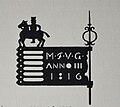
Weather vane from 1816

Weather vane from 1811
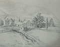
Drawing from 1830

Floor plan of the basement and ground floor

Location map


See also
Individual evidence
- ↑ Ursula Quednau (arrangement): Dehio-Handbuch der Deutschen Kunstdenkmäler, North Rhine-Westphalia, Volume II: Westphalia. Deutscher Kunstverlag, Berlin / Munich 2011, ISBN 978-3-422-03114-2 , p. 831 f.
literature
- Friedhelm Ackermann, Alfred Bruns: Castles and palaces and monasteries in the Sauerland. Strobel Verlag, 1985, ISBN 3-88793-006-14 .
- Klaus Gorzny: Ruhr castles. Marl 2002, ISBN 3-9801776-7-X , pp. 40-42.
- Ursula Quednau (arrangement): Dehio-Handbuch der Deutschen Kunstdenkmäler, North Rhine-Westphalia, Volume II: Westphalia. Deutscher Kunstverlag , Berlin / Munich 2011, ISBN 978-3-422-03114-2 , p. 831 f.
Web links
- Entry by Jens Friedhoff zu Bruchhausen near Olsberg in the scientific database " EBIDAT " of the European Castle Institute
- Fürstenberg-Gaugreben administration
- Online finding aid "Archiv Bruchhausen, Gaugreben-Bruchhausen" , use takes place via the LWL archives office .

Styrum Castle | Broich Castle | Motte Nettelshof | Hugenpoet Castle | Landsberg Castle | Oefte Castle | Luttelnau Castle | Baldeney Castle | New Isenburg | Schellenberg Castle | Holtey Castle | House Horst | Altendorf Castle | Rauendahl Castle | Isenburg | Blankenstein Castle | House Kemnade | Hardenstein Castle | Steinhausen Castle | Volmarstein Castle | Castle weather | Werdringen moated castle | Hohensyburg | House Villigst | House Ruhr (Hengsen) | House Opherdicke | Dahlhausen Castle | Ardey Castle | House Fruits | Hünenknfer Castle | Höllinghofen Castle | Oldenburg Castle | Herdringen Castle | Rüdenburg | Arnsberg Castle | Wildshausen Castle | Stesser Castle | Laer Castle | Hünenburg | Eversberg Castle | Gevelinghausen Castle | Schellenstein Castle | Antfeld Castle | Bruchhausen Castle | Wildenberg Castle
Coordinates: 51 ° 19 ′ 12 " N , 8 ° 31 ′ 50" E