Schmittlotheim
|
Schmittlotheim
Vöhl municipality
Coordinates: 51 ° 9 ′ 11 ″ N , 8 ° 54 ′ 5 ″ E
|
|
|---|---|
| Height : | 265 m above sea level NHN |
| Area : | 8.78 km² |
| Residents : | 264 (2014) |
| Population density : | 30 inhabitants / km² |
| Incorporation : | December 31, 1971 |
| Incorporated into: | Hessenstein |
| Postal code : | 34516 |
| Area code : | 05635 |
|
Location of Schmittlotheim in Vöhl
|
|
|
The place in the evening sun in March
|
|
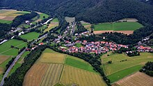
Schmittlotheim is a district of the municipality of Vöhl in the northern Hessian district of Waldeck-Frankenberg .
Geographical location
Schmittlotheim is just under seven kilometers (as the crow flies ) south-southwest of Vöhl, the core town of the municipality, in the Eder valley between the Vöhler districts of Ederbringhausen in the south-southwest and Kirchlotheim in the north. The village is on the Warburg – Sarnau railway line . It is surrounded by the steeply rising mountains of the Ederbergland and by vast beech forests of the Kellerwald low mountain range , in the northern part of which the Kellerwald-Edersee National Park is located. This is framed by the Kellerwald-Edersee nature park , in which the Edersee reservoir extends . The village is traversed by the Lorfe (Lorfebach), which flows into the Eder below Schmittlotheim.
history
The ending “-heim” suggests a Frankish-Chattic settlement of the area between the 5th and 8th centuries. This is supported by the mention of the 8th century Altburgstelle Burg am Ofen, about one kilometer north of Schmittlotheim .
The place was first mentioned in a document in 1264 as "Smedelotheim" (Lotheim with the smithy). Schmittlotheim belonged to the Itter rule and was part of the Bailiwick of the Bailiffs of Keseberg .
At 31 December 1971 in the wake of were municipal reform in Hesse , the previously independent municipalities Schmittlotheim, Buchenberg , Ederbringhausen , Harbshausen , Kirchlotheim , Niederorke and Oberorke dissolved and merged to Hessenstein together .
On January 1, 1974, the municipality of Hessenstein was again merged by state law with Ittertal (consisting of the former municipalities of Dorfitter , Herzhausen and Thalitter ), Marienhagen , Obernburg and Vöhl to form the new large municipality of Vöhl. Local districts were established for all formerly independent communities .
The Warburg – Sarnau railway was opened in 1900 with a station in Schmittlotheim, but was shut down in 1987. Trains have stopped here again since September 11, 2015, the line connects Brilon and Korbach via Schmittlotheim with Frankenberg (Eder) and Marburg (Lahn), and there is a connection to Kassel in Korbach.
Townscape
Half-timbered houses that are well worth seeing characterize the town center, which today still reflect the village character of Schmittlotheim.
Individual evidence
- ↑ a b The place on the website of the municipality of Vöhl , accessed in April 2016.
- ↑ a b Federal Statistical Office (ed.): Historical municipality register for the Federal Republic of Germany. Name, border and key number changes in municipalities, counties and administrative districts from May 27, 1970 to December 31, 1982 . W. Kohlhammer, Stuttgart / Mainz 1983, ISBN 3-17-003263-1 , p. 390-391 .
- ↑ Law on the reorganization of the districts of Frankenberg and Waldeck (GVBl. II 330-23) of October 4, 1973 . In: The Hessian Minister of the Interior (ed.): Law and Ordinance Gazette for the State of Hesse . 1973 No. 25 , p. 359 , § 6 ( online at the information system of the Hessian state parliament [PDF; 2,3 MB ]).
Web links
- The place on the website of the municipality of Vöhl
- Schmittlotheim, Waldeck-Frankenberg district. Historical local dictionary for Hessen. In: Landesgeschichtliches Informationssystem Hessen (LAGIS).
- Literature on Schmittlotheim in the Hessian Bibliography


