
Sichelbach basin
| Sichelbach basin | |||||||||
|---|---|---|---|---|---|---|---|---|---|
 |
|||||||||
|
|||||||||
|
|||||||||
| Coordinates | 51 ° 19 '3 " N , 9 ° 22' 42" E | ||||||||
| Data on the structure | |||||||||
| Construction time: | Early 18th century | ||||||||
| Height above foundation level : | approx. 10 m | ||||||||
| Crown length: | approx. 250 m | ||||||||
| Data on the reservoir | |||||||||
| Altitude (at congestion destination ) | approx. 540 m above sea level NHN | ||||||||
| Water surface | approx. 6,300 m² | ||||||||
| Reservoir length | approx. 90 m | ||||||||
| Reservoir width | approx. 70 m | ||||||||
| Storage space | approx. 40,000 m³ | ||||||||
| Particularities: |
Main storage basin of the baroque part of the Kassel water features |
||||||||

The Sichelbach basin (also Sichelbach reservoir or Sichelbachteich ) is a reservoir in the Hohen Habichtswald, west of the north Hessian city of Kassel .
It is the main storage basin of the oldest, baroque part of the Kassel water features in the Bergpark Wilhelmshöhe and was created when construction work on the Hercules began around 1700.
Geographical location
The Sichelbach basin is located on the high altitude of the Hohen Habichtswald in the Habichtswald Nature Park . In the west of the Kassel city area, it is right on the border with the Habichtswald community 1,050 m (as the crow flies ) west of the Hercules at around 540 m above sea level. NHN on the wooded eastern foothills of the 597 m high stone pile .
description
The rectangular, up to 7 m deep Sichelbach basin, which as a reservoir has a capacity of around 40,000 m³ and a surface area of 6,300 m², is fed by surface and spring water from the adjacent high plateau to which the Essigberg also belongs. The embankment of the basin is about 250 m long.
From the Sichelbach basin, the water reaches the underground through the valley basin through a pipe based on the principle of communicating pipes to the rectangular extinguishing water pond , the walled reservoir between the “Oktogon” and the upper parking lot at the “Zum Herkules” restaurant. The eponymous Sichelbach, on the other hand, flows around this hollow in a sickle shape and flows into the partially underground "Unglücksteich", which is located a little below the Octagon of Hercules, to the left of the "Artichoke Basin". The last 100 m of this brook were built underground from the beginning, only in the 20th century further sections of the brook were banned from the surface. Both pools - the "Löschwasserteich" and the "Unglücksteich" - feed the water features in Bergpark Wilhelmshöhe.
Vorwerk Sichelbach
Immediately below the Sichelbach Basin dam, which surrounds the reservoir on three sides, is the Sichelbach Vorwerk , whose predecessor building was built as a stable during construction work between 1701 and 1717. Today there is a brick building from the second half of the 19th century next to the house .
inflow
Essigberg trench system
With the construction of the Sichelbach Reservoir, a system of ditches was also created, which was used to collect water on the Essigberg , especially when the snow was melting . Today's spruce monocultures east of the radio tower are likely to have been hat areas at that time and may have already had a network of drainage ditches that was expanded and developed. The water still flows from there to the north, to the western end of Kastanienallee on the former Bundeswehr site.

approx. 200 m east of the radio tower (2019)

approx. 300 m northeast of the radio tower (2019)

approx. 450 m northeast of the radio tower (2019)

approx. 600 m northeast of the radio tower (2019)

approx. 950 m northeast of the radio tower, meadow on Kastanienallee (2019)


Tributary ditch
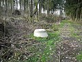
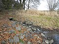
In the pasture at the western end of Kastanienallee, by the former Bundeswehr area, the water of the Essigberg is divided: into the course of the ancestor and into the inflow into the Sichelbach reservoir. This inflow has been underground piping since the 1960s. The historic, open tributary ditch is still preserved alongside this piping, but is no longer used. Long stretches of the historic ditch have been almost filled in due to forest work. In some places there are also inflows from the forest area south of the inflow ditch into the piping. The underground piping only ends immediately before the Sichelbach reservoir.

Historic remains of a moat south of Kastanienallee (2019)
Inspection shaft of the piping, the trench to the left of it filled (2019)

Timber harvest at the historic tributary ditch (2019)

Inflow ditch directly west of the Sichelbach Reservoir (2019)
Outlet of the piping at the Sichelbach reservoir (2019)


Individual evidence
- ↑ a b Map services of the Federal Agency for Nature Conservation ( information )
- ↑ according to Siegfried Hoß: 2.3.1. The water arts and their catchment area in Park Wilhelmshöhe Kassel Parkpflegewerk , 2007, pp. 256–259
- ↑ cf. Siegfried Hoß: 2.3.1. The water arts and their catchment area in Park Wilhelmshöhe Kassel Parkpflegewerk , 2007, pp. 259–260
literature
- Paul Heidelbach: The history of Wilhelmshöhe. Klinkhardt & Biermann, Leipzig 1909
- Facsimile, Ed .: Dieter Carl, Vellmar 2005