
Seven Reasons
| The seven reasons of the Elbe | |
|---|---|
| The Elbe rises from eleven wells ... (top right "Rübezahls Nest" near Mittagstein .) |
|
.jpg)
|
|
| Text from the "New Pocket Book for Travelers" |
.jpg)
The Siebengrund ( Czech Sedmidolí ) denote an area rich in myths from which the source streams of the Elbe feed. The adjacent section of the oldest map of the Giant Mountains by Simon Hüttel , which was created between 1576 and 1585, shows eleven headwaters of the Elbe. (The full view of the map can be seen here .)
backgrounds
It is not entirely unambiguous to clarify which place is denoted by the name. There are passages in the text that locate the area between the Elbe meadow and the Koppenplan ( Równia pod Śnieżką ) on the southern slope of the Silesian Ridge . There, however, the term seems to be used in a more figurative sense. A more plausible explanation is usually provided by older writings, which only summarize the southern transverse valleys of the eastern main ridge under this term.
In this context, other headwaters of the Elbe are of course also important. Some texts report on eleven sources that converge on the Elbwiese. "It comes from eleven wells, the most distinguished of which are the Elb-Brunn, Weißbrunn and Mehdelgrund", claims the "Historical and Geographical Description of the Kingdom of Böheim" from 1746. The Hüttel map mentioned above seems even more precise, but it is called also "the devil personally drilled eleven springs on the Elbe".
At the end of the 17th century it was decided to “relocate” the source of the Elbe from the White White ( Bílá louka ) to the Elbe meadow ( Labská louka ). This was done with the intention of settling centuries-old border disputes between the Counts Harrach , Morzin and Schaffgotsch . This has not helped to simplify the question of where to find the seven reasons, and it is often not possible to know exactly what you are talking about. The adjacent illustration of a travel guide from 1837 shows without a doubt that the white water ( Bílé Labe ) is named as the actual source river and is equated with the "Elbe".
From a hydrological point of view, this is undisputed, because the headwaters of the White Elbe , the literal translation of the Czech name, is not only higher, but also longer. In addition, it carries more water at the mouth than the Elbseifen or Elbbach, which was called Labe in Bohemian early on , i.e. Elbe. According to the standards mentioned, it actually wrongly bears the name of the main river.
Seven reasons
- In the "Weißwassergrund" ( Důl Bílého Labe ), the probably wildest tributary of the Elbe rushes. The white water, the largest spring stream, rises 1400 meters high on the southern edge of the marshy white meadow, near the meadow hut ( Luční bouda ). After the torrent has taken its way down into the valley with a steep gradient, a number of smaller streams strengthen it. The most important of these so-called fins and soaps or their valleys are, sorted according to their confluence with the white water, the following:
- Silver water (Stříbrná bystřina) flows through the "Silbergrund". The first right-hand white water tributary rises in the area of the Teufelswiese ( Čertovy Louky ) between Mittagsberg (Polish Smogornia , Czech Stříbrný hřbet ) and the western slope of the White Meadow.
- The “Devil's Ground” ( Čertův důl ) was cut deep into the southern slope of the Little Balaclava by the Devil's Stream ( Čertova struha ). The Krummseifen, as another name of the brook is, is fed from several sources on the Teufelswiese.
- The "storm ditch" (also balaclava ground ) is drained by the balaclava water ( Hřímavá bystřina ), which rises at an altitude of 1185 meters under the west side of the Great Balaclava , about 250 meters from the Spindler pass.
- The “black ground”, through which the black water ( Černý potok ) flows, is also on the west side of the Great Balaclava. The source of the brook, which is also called Schwarzfloss or Schwarzbach, is located here at an altitude of 1040 meters.
- The "Löchelgraben" houses the water-rich Löchelfloss ( Dírečka ). This brook has its source at the Löchel , the deepest point of the main ridge at 1178 meters, and flows into the red raft at the Leierbauden ( Jeleni boudy ).
- The "Mädelgrund" ( Dívčí stráň ) is the deeply cut valley of the Rotbach (also Rotfloss or Rothwasser, Czech Červený potok ). The mountain stream is reinforced by the sources around the Vogelstein ( Ptačí kámen ) and rises at an altitude of about 1260 meters on the east side of the Mädelwiese, near the former Peterbaude below the Mädelsteine ( Śląskie Kamienie in Polish , Dívčí Kameny in Czech ). From where it flows into the Weißwasser, the valley no longer bears the usual name, but is also referred to as the Mädelgrund up to the confluence with the Elbseifen at the Mädelsteg.
Four more reasons
- In the " Elbgrund " ( Labský důl ) flows the Elbseifen or Elbbach, whose sources lie on the Elbe meadow , where many small water veins are contained in the so-called Elbe fountain at an altitude of 1386 meters . This source of the smaller Elbquellbach has been regarded as the source of the Elbe since the inauguration by the Bishop of Königgrätz , Johann Franz Christoph von Talmberg , on September 19, 1684. About one kilometer for the source of the water falls as Elbfall 40 meters deep in the rocky valley of Elbkessels ( Labská jáma ) and continues to flow in the southeastern direction. In this way, the young Elbe absorbs the water from the following valleys, i.e. grounds or ditches:
- The "Pudelgraben" is formed by the Pudelgrundbach ( Pudlava ), which rises from the Pudelbaude below the Hohen Rades ( Wielki Szyszak in Polish , Vysoké Kolo in Czech ). Its water falls over the 38 meter high Pudelfall ( Pudlavský vodopád ) before it merges with the Elbe soap.
- The "Hofgraben" (also Martinsgrund) is the valley floor of the Hofbach (or Martinswasser, Czech Dvorský potok ), the headwaters of which can be found below the southern slope of the Hohen Rad near the Martinsbaude ( Martinova bouda ). Here, too, there is a waterfall to be admired: in the Hofgrabenfall ( Dvorský vodopád ) the stream plunges 68 meters into the depth and a little later also flows into the Elbe soap.
- The "Bärengrund" is the bed of the Bärenbach (also Bärenwasser and formerly Bärenbad, Medvědí potok in Czech ), whose water comes from the swampy ground of the Mädelwiese. The wet meadow , which is also called Bärenbrunn, is located between the Hohe Rad and the Kleiner Sturmhaube ( Maly Sisak ). From here the brook falls more than it flows over several stone cascades before its water is absorbed by the Elbe soap.
A twelfth reason?
Regardless of where the Siebengrunds are to be found, the Pančava brook was not included in all descriptions of the Sedmidolí, presumably because of the comparatively small amount of water. It rises on the Pantschewiese ( Pančavská Louka ) south of the Elbe Meadow and is the only flow to Elbseifen from the right. It is famous for the 148 meter high Pantschefall .
Historical map

gallery

The Pantschefall with a view of the Elbe Valley

The white water at the Mädelsteg

The Löchelfloss in the Löchelgraben

The Elbwiese near the source of the Elbe
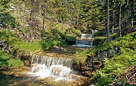
The Teufelsbach


.jpg)


Web links
Individual evidence
- ↑ The area of the Seven Reasons (PDF, 9 MB)
- ^ Historical and geographic description of the Kingdom of Böheim
- ↑ Illustrated guide through the Giant Mountains
- ↑ The sources of the Elbe (PDF, 6 MB)
- ^ Educational trail "Devil's Ground - Čertův důl"
- ↑ a b The Kingdom of Bohemia, presented statistically and topographically by Johann Gottfried Sommer