Sioux City
| Sioux City | |
|---|---|
 In the center of Sioux City |
|
| Location of Sioux City in Iowa | |
| Basic data | |
| Foundation : | 1854 |
| State : | United States |
| State : | Iowa |
| Counties : |
Woodbury County Plymouth County |
| Coordinates : | 42 ° 30 ′ N , 96 ° 24 ′ W |
| Time zone : | Central ( UTC − 6 / −5 ) |
|
Inhabitants : - Metropolitan Area : |
82,872 (as of 2016) 169,140 (as of 2016) |
| Population density : | 557.9 inhabitants per km 2 |
| Area : | 151.5 km 2 (approx. 58 mi 2 ) of which 148.54 km 2 (approx. 57 mi 2 ) is land |
| Height : | 366 m |
| Postcodes : | 51101-51106, 51108, 51109, 51111 |
| Area code : | +1 712 |
| FIPS : | 19-73335 |
| GNIS ID : | 0461653 |
| Website : | www.sioux-city.org |
| Mayor : | Bob Scott |
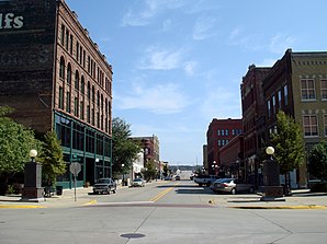
 Historic Fourth Street |
|
Sioux City [ ˌsuːsɪti ] is a city (with the status " City ") and the administrative seat of Woodbury County in the US -amerikanischen State Iowa . A small portion of the urban area extends into neighboring Plymouth County . In 2010 Sioux City had 82,684 inhabitants, the number of which changed little until 2016 (2016 estimate, US Census Bureau ). This makes Sioux City the fourth largest city in the state.
The KCAU television transmission mast erected here was one of the tallest structures on earth in 2009 with its 609.6 m.
Sioux City is located in the center of the Sioux City Metropolitan Area , which stretches from Iowa to the neighboring states of South Dakota and Nebraska .
geography
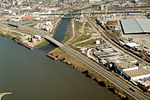
Sioux City is located in western Iowa at the confluence of the Big Sioux River with the Missouri . The Big Sioux River forms the border between Iowa and South Dakota and the Missouri the border with Nebraska . The Floyd River also flows into the Missouri in Sioux City . The navigability of the Missouri begins in Sioux City.
The geographical coordinates of Sioux City are 42 ° 29'53 "north latitude and 96 ° 23'44" west longitude. The urban area extends over an area of 151.5 km², which is spread over 148.54 km² of land and 2.96 km² of water. The city does not belong to any township .
Neighboring towns to Sioux City are Hinton (11 miles northeast), Lawton (12 miles east), Bronson (12 miles southeast), Sergeant Bluff (on the southern outskirts), South Sioux City (on the opposite bank of the Missouri in Nebraska) , Dakota City (10.7 km south), Dakota Dunes in South Dakota and North Sioux City in South Dakota (on the western city limits) and Jefferson in South Dakota (14.6 km northwest).
The closest major cities are the Twin Cities in Minnesota ( Minneapolis and Saint Paul ) (435 km northeast), Rochester , Minnesota (437 km east-northeast), Cedar Rapids (425 km east), Iowa's capital Des Moines (305 km east-southeast), Nebraskas largest city Omaha (162 km south-southeast), Kansas City in Missouri (448 km in the same direction), Nebraska's capital Lincoln (205 km south) and South Dakota's largest city Sioux Falls (140 km north-northwest).
Climate table
| Sioux City, Iowa | ||||||||||||||||||||||||||||||||||||||||||||||||
|---|---|---|---|---|---|---|---|---|---|---|---|---|---|---|---|---|---|---|---|---|---|---|---|---|---|---|---|---|---|---|---|---|---|---|---|---|---|---|---|---|---|---|---|---|---|---|---|---|
| Climate diagram | ||||||||||||||||||||||||||||||||||||||||||||||||
| ||||||||||||||||||||||||||||||||||||||||||||||||
|
Average monthly temperatures and rainfall for Sioux City, Iowa
|
|||||||||||||||||||||||||||||||||||||||||||||||||||||||||||||||||||||||||||||||||||||||||||||||||||||||||
traffic
Interstate Highway 29 runs through the center of Sioux City and runs along the Missouri, making it the shortest connection from Kansas City to the Canadian border. The I 129 leads over a bridge over the Missouri and forms the western arterial road from Sioux City. US Highways 20 , 75 and 77 and Iowa State Highway 12 continue to meet in the urban area . All other roads are subordinate country roads, some unpaved roads and inner-city connecting roads.
Sioux City is a rail hub where several lines of the BNSF Railway , the Union Pacific Railroad (UP) and the Canadian National Railway (CN) meet. In addition, the Sioux City Bridge, a railway bridge that crosses the Missouri, goes back to one of the first bridges over the river in 1888.
The Sioux Gateway Airport in the south of the city is the fourth largest airport in Iowa by passenger volume. The city and the airport gained a certain prominence in Europe as the setting for the film Disaster Flight 232 , which is based on United Airlines Flight 232 .
Colleges
| Population development | |||
|---|---|---|---|
| Census | Residents | ± in% | |
| 1870 | 3965 | - | |
| 1880 | 7366 | 85.8% | |
| 1890 | 37,806 | 413.3% | |
| 1900 | 33.111 | -12.4% | |
| 1910 | 47,828 | 44.4% | |
| 1920 | 71,227 | 48.9% | |
| 1930 | 79.183 | 11.2% | |
| 1940 | 82.364 | 4% | |
| 1950 | 83.991 | 2% | |
| 1960 | 89,159 | 6.2% | |
| 1970 | 85,925 | -3.6% | |
| 1980 | 82.003 | -4.6% | |
| 1990 | 80.505 | -1.8% | |
| 2000 | 85.013 | 5.6% | |
| 2010 | 82,684 | -2.7% | |
| 2016 estimate | 82,872 | 0.2% | |
| 1870-2000 2010-2016 | |||
population
According to the 2010 census , Sioux City had 82,684 people in 31,571 households. The population density was 556.6 inhabitants per square kilometer. Statistically, 2.54 people lived in each of the 31,571 households.
The racial the population was composed of 80.6 percent white, 2.9 percent African American, 2.6 percent Native American, 2.7 percent Asian, 0.1 percent Polynesian and 7.4 percent from other ethnic groups; 3.7 percent were descended from two or more races. Hispanic or Latino of any race was 16.4 percent of the population.
26.6 percent of the population were under 18 years old, 61.0 percent were between 18 and 64 and 12.4 percent were 65 years or older. 50.8 percent of the population were female.
The average annual income for a household was 43,449 USD . The per capita income was $ 22,143. 16.9 percent of the population lived below the poverty line.
tragedies
On 19th July 1989 a crashed McDonnell Douglas DC-10 flight United Airlines Flight 232 at the emergency landing on the Sioux Gateway Airport from. It broke and went up in flames. The reason was a complete loss of pressure in the hydraulic systems due to a broken component of the low-pressure compression in the rear engine . 110 of the 285 people on board were killed.
sons and daughters of the town
- William Edwards Deming (1900–1993), pioneer in the field of quality management
- Morgan Taylor (1903-1975), track and field athlete
- Peggy Gilbert (1905-2007), jazz musician
- Winifred Asprey (1917–2007), mathematician and computer scientist
- Pauline Phillips (1918–2013), newspaper columnist
- John Melcher (1924–2018), Democratic Party politician
- Alan J. Heeger (* 1936), Nobel Laureate
- Tommy Bolin (1951-1976), rock guitarist
- David Loebsack (* 1952), politician
- Lawrence Zoernig (1960–2017), cellist and composer
- Ryan Kisor (* 1973), jazz trumpeter
- Kirk Hinrich (* 1981), basketball player
- Ben Jacobson (born 1983), basketball player
Town twinning
-
 Lake Charles , United States, since 1995
 -
 Yamanashi , Japan, since 2003
Individual evidence
- ↑ City of Sioux City - City Council ( Memento of the original from January 17, 2015 in the Internet Archive ) Info: The archive link was inserted automatically and has not yet been checked. Please check the original and archive link according to the instructions and then remove this notice. Retrieved January 16, 2015
- ↑ Distance information according to Google Maps. Accessed on January 16, 2015
- ↑ Sioux Gateway Airport.Retrieved January 16, 2015
- ↑ AirNav.com - Sioux Gateway Airport Accessed on January 16, 2015
- ↑ State Data Center of Iowa (PDF; 86 kB) Retrieved January 16, 2015
- ↑ a b American Fact Finder. Retrieved January 16, 2015

