
Slovenská Ľupča
| Slovenská Ľupča | |||
|---|---|---|---|
| coat of arms | map | ||

|
|
||
| Basic data | |||
| State : | Slovakia | ||
| Kraj : | Banskobystrický kraj | ||
| Okres : | Banská Bystrica | ||
| Region : | Horehrony | ||
| Area : | 32.325 km² | ||
| Residents : | 3,257 (Dec. 31, 2019) | ||
| Population density : | 101 inhabitants per km² | ||
| Height : | 378 m nm | ||
| Postal code : | 976 13 | ||
| Telephone code : | 0 48 | ||
| Geographic location : | 48 ° 45 ' N , 19 ° 14' E | ||
| License plate : | BB | ||
| Kód obce : | 509001 | ||
| structure | |||
| Community type : | local community | ||
| Administration (as of November 2018) | |||
| Mayor : | Roland Lamper | ||
| Address: | Obecný úrad Slovenská Ľupča Nám. SNP 13 97613 Slovenská Ľupča |
||
| Website: | www.slovenskalupca.sk | ||
| Statistics information on statistics.sk | |||

Slovenská Ľupča (until 1927 Slovak also "Zvolenská Ľupča"; German Slovak Liptsch or older Bohemian Luptsch , Hungarian Zólyomlipcse - until 1882 also Tótlipcse ) is a municipality in central Slovakia . It is located in the Grant Valley at the foot of the Low Tatras and Poľana, about 12 km from Banská Bystrica .
The place was first mentioned in writing in 1250. In 1944 the village of Ľupčianska Ulica was incorporated.
Attractions
- Gothic Roman Catholic Church of the Holy Trinity
- the Liptsch Castle from the 13th century
Sons and daughters of the church
- Tibor Andrašovan (1917–2001), composer and conductor
- Emil Belluš (1899–1979), architect
- Samuel Czambel (1856–1909), linguist and translator
- Bohuslav Cambel (1919–2006), geologist and university professor
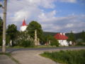
View of the church in the village

Municipal office in Slovenská Ľupča
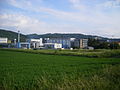
The factories of Evonik Fermas, sro and Biotika near the place

Lipch Castle


Web links
Commons : Slovenská Ľupča - collection of pictures, videos and audio files