
Solar eclipse of October 14, 2023
| Solar eclipse of October 14, 2023 | |
|---|---|

|
|
| classification | |
| Type | Ring-shaped |
| area |
North , Central and South America , Eastern Pacific , Western Atlantic Annular: Southwest USA , Gulf of Mexico , Yucatán , Central America , Colombia , northern Brazil |
| Saros cycle | 134 (44 of 71) |
| Gamma value | +0.3752 |
| Greatest eclipse | |
| Duration | 5 minutes 17 seconds |
| place | Caribbean Sea off the coast of Nicaragua |
| location | 11 ° 22 ′ N , 83 ° 4 ′ W |
| time | October 14, 2023 5:59:21 PM UT |
| size | 0.9520 |

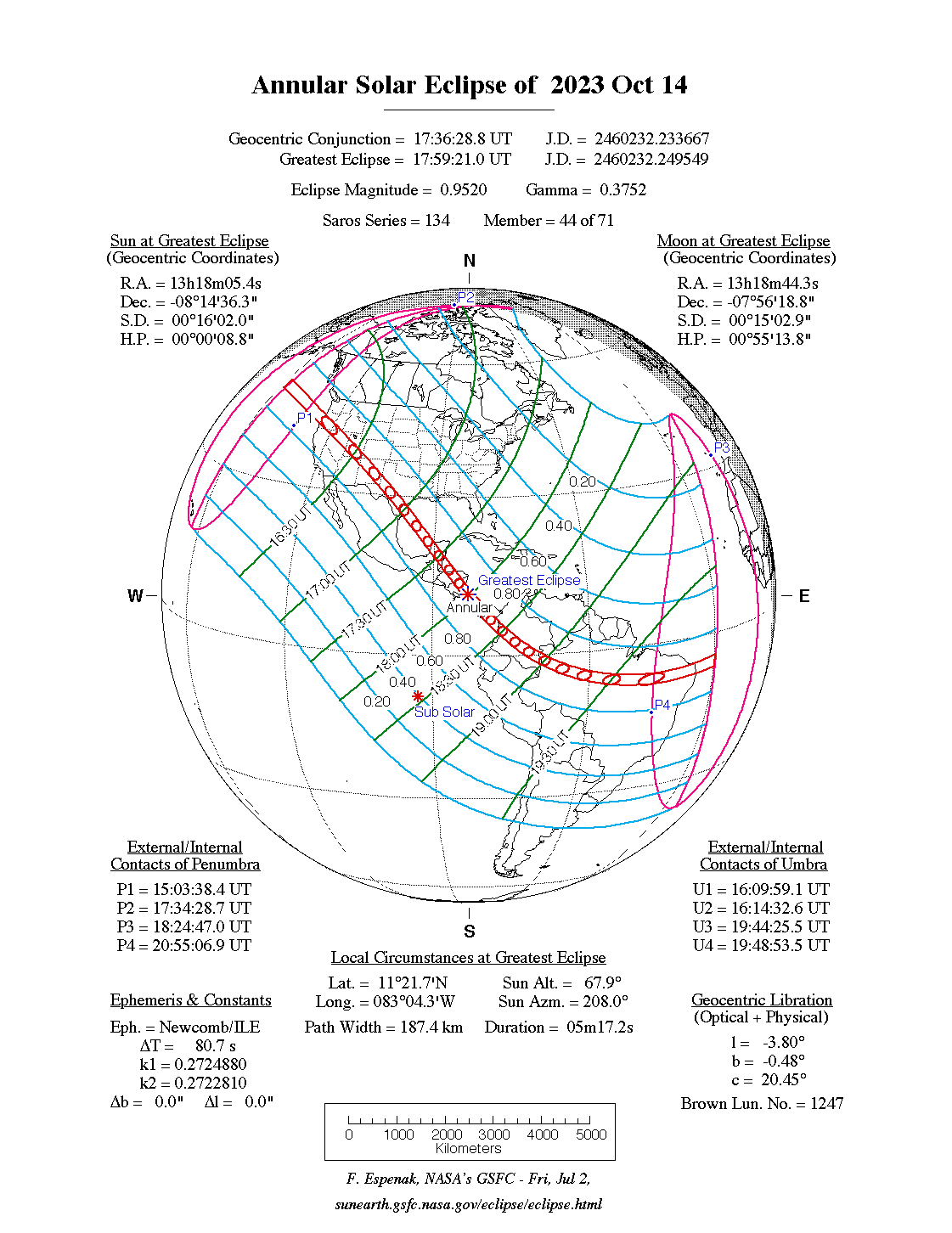
The annular solar eclipse of October 14, 2023 takes place largely over North , Central and South America .
The maximum of the eclipse is in Central America , with the place of greatest occultation off the east coast of Nicaragua and the place of the longest duration of the eclipse just off the south coast of Panama . There the duration of the ring-shaped occultation is 5 minutes and 17 seconds, the sun is 66.8 ° above the horizon.
The solar eclipse belongs to the Saros cycle 134 and is the successor to the solar eclipse of October 3, 2005 .
course
The zone of annular visibility first reaches Earth in the eastern Pacific at 146 ° 14 ' west longitude and 49 ° 14' north latitude at 16h 12m UT . On the way to the southeast, the shadow meets the coast of the USA at Coos Bay . The shadow path then crosses the mainland and the American states of Oregon, Nevada, Utah, New Mexico and Texas. It then passes through the western Gulf of Mexico , the Yucatán peninsula and northeastern Honduras , passes the coast of Costa Rica , crosses the Isthmus of Panama west of the Panama Canal and continues across the ocean to Colombia. The shadow moves to the Colombian coast through sparsely populated areas, first over the Andes and then along the Rio Solimões in Brazil, where it only reaches more densely populated areas again in the northeastern states . Here, however, the sun is already very close to the western horizon. The moon's shadow leaves the earth again at 29 ° 46 ′ west longitude and 5 ° 46 ′ south latitude at 19h 46m UT shortly before the Brazilian east coast.
The zone of circular visibility touches many national parks and other protected areas. In the USA Crater Lake , Great Basin , Capitol Reef , Canyonlands and Padre Island , in Panama Santa Fe , Omar Torrijos , Sarigua , in Colombia Uramba , Cordillera de los Picacho , Serranía de la Macarena , Chiribiquete , in Brazil Jaú , Amazônia , Jamanxim , Serra do Pardo .
About 100 km west of the Texas city of Austin , near the town of Vanderpool in Bandera County , is the intersection of the central line of the total solar eclipse of April 8, 2024 , so that two central solar eclipses can be seen here less than 6 months apart. For Albuquerque , this eclipse is the second annular solar eclipse in 11 years, here the shadow path of the solar eclipse of May 20, 2012 is crossed.
Places in the zone of circular visibility
| country | place | Duration | Time ( UT ) | comment |
|---|---|---|---|---|
| United States | Coos Bay | 4m 00s | 16h 18m | first contact with land |
| United States | Eugene | 3m 54s | 16h 19m | |
| United States | Medford | 1m 13s | 16h 19m | at the edge of the annular zone |
| United States | Electrolytic capacitor | 4m 18s | 16h 25m | |
| United States | Albuquerque | 4m 50s | 16h 37m | |
| United States | Santa Fe | 2m 49s | 16h 37m | at the edge of the annular zone |
| United States | Roswell | 4m 41s | 16h 41m | |
| United States | Odessa | 4m 48s | 16h 45m | |
| United States | Vanderpool | 4m 59s | 16h 52m | Crossing point to the central line of the total solar eclipse of April 8, 2024 |
| United States | San Antonio | 4m 24s | 16h 54m | |
| United States | Corpus Christi | 5m 02s | 16h 58m | |
| Mexico | Campeche | 4m 33s | 17h 25m | |
| Belize | Belize City | 5m 11s | 17h 34m | |
| Honduras | La Ceiba | 5m 11s | 17h 41m | |
| Honduras | Catacamas | 5m 15s | 17h 45m | |
| Panama | Santiago de Veraguas | 4m 09s | 18h 12m | |
| Colombia | Cali | 3m 44s | 18h 33m | |
| Colombia | Neiva | 5m 09s | 18h 37m | |
| Brazil | Araguaína | 4m 09s | 19h 39m | |
| Brazil | Juazeiro do Norte | 3m 52s | 19h 45m | only about 10 ° above the horizon |
| Brazil | Campina Grande | 3m 04s | 19h 46m | only about 7 ° above the horizon |
| Brazil | natal | 3m 32s | 19h 45m | only about 6 ° above the horizon |
The cities of Tegucigalpa , Panama City , Bogotá , Manaus, and the northeast coast of Costa Rica are just missed by the zone of circular visibility.
Web links
- solar-eclipse.de: The annular solar eclipse from October 14th, 2023
- NASA: Annular Solar Eclipse of 2023 Oct 14
- NASA: Google Maps and Solar Eclipse Paths: 2021-2040
- NASA: Solar Eclipses of Saros 134
- NASA: Interactive Map for Annular Solar Eclipse of 2023 Oct 14
- NASA: Path of Annular Solar Eclipse of 2023 Oct 14
Individual evidence
- ^ A b Fred Espenak: Fifty Year Canon of Solar Eclipses: 1986-2035 . Ed .: NASA . 2nd Edition. Sky Publishing, Belmont 1994, ISBN 0-933346-45-X , pp. 121, 225 .
- ↑ a b The duration of the totality and the time of the middle of the totality were determined with the interactive map of NASA.
|
Previous solar eclipses:
|
Later solar eclipses:
|
|||||||||
|
June 10, 2021 (circular) |
4 December 2021 (total) |
April 30, 2022 (partial) |
October 25, 2022 (partial) |
April 20, 2023 (hybrid) |
October 14, 2023 (ring-shaped) |
April 8, 2024 (total) |
October 2, 2024 (ring-shaped) |
March 29, 2025 (partial) |
September 21, 2025 (partial) |
February 17, 2026 (ring-shaped) |
|
|
|
|
|
|
|
|
|
|
|
|
| Lists: 20th century • 21st century • All lists | ||||||||||