South Tarawa
| South Tarawa | ||
|---|---|---|
|
|
||
| Coordinates | 1 ° 20 ′ N , 172 ° 59 ′ E | |
| Basic data | ||
| Country | Kiribati | |
| Gilbert Islands | ||
| ISO 3166-2 | KI-G | |
| Residents | 56,388 (2015) | |
|
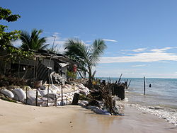
Coastal erosion from rising seas in South Tarawa
|
||
South Tarawa (also Teinainano Urban Council or TUC ) is the capital of the Republic of Kiribati in the central Pacific . It has around 56,400 inhabitants (as of 2015).
The island of Bairiki was also referred to as the capital of the island state because of the earlier concentration of government agencies, which are now mainly distributed over three islands.
During World War II, South Tarawa with Betio was the focus of the battle for the Gilbert Islands .
geography
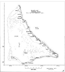
South Tarawa comprises the southern islands of the Tarawa Atoll , from east to west: Tanaea , Bonriki (with airport and Bikenibeu ), Eita , Ambo (with parliament building), Nanikai and Bairiki . The total area of the district is 14.09 km² (excluding Betio). Betio has been forming its own district (Betio Town Council) for some time and is no longer part of the South Tarawa district.
Consequences of climate change
In South Tarawa, the consequences of climate change are already being felt, as sea levels rise, causing coastal erosion and salinization of freshwater sources. Since the situation on many neighboring atolls is even more precarious, many people have fled from the surrounding atolls to South Tarawa. Due to the constant influx, South Tarawa has to contend with overpopulation, as the population density is now comparable to that in Tokyo . Supplying the growing population with food, water and sanitation is now becoming difficult.
population
With almost 56,400 inhabitants (as of 2015), more than half of the total population of the island republic live in the South Tarawa district . The populated area extends over several islands of the atoll connected by navigable dams and has an extension of almost 30 km in length with a maximum width of just over one kilometer.
Demographic statistics
| census | place | 1978 | 2005 | 2010 | 2015 |
|---|---|---|---|---|---|
| east | Tanaea | 27 | 91 | 279 | 198 |
| Bonriki | 635 | 2119 | 2355 | 2829 | |
| Temwaiku | - | 2011 | 3135 | 4072 | |
| Causeway | - | 1780 | 2054 | 1843 | |
| Bikenibeu | 3971 | 6170 | 6568 | 7575 | |
| Abarao | 322 | 908 | 1665 | 1761 | |
| Eita | 612 | 2299 | 3061 | 3395 | |
| Tangintebu | 128 | 94 | 89 | 150 | |
| Taborio | 187 | 955 | 1282 | 1293 | |
| west | Ambo | - | 1688 | 2200 | 2780 |
| Banraeaba | 501 | 1789 | 1969 | 2072 | |
| Antebuka | 504 | 390 | 1087 | 1615 | |
| new campus | Teaoraereke | 848 | 3939 | 4171 | 5105 |
| Nanikai | 604 | 803 | 988 | 1152 | |
| Bairiki | 1956 | 2766 | 3524 | 3218 | |
| Betio | Betio | 7626 | 12,509 | 15,755 | 17,330 |
| total | 17,921 | 40,311 | 50,182 | 56,388 |
Population development
| census | 1947 | 1963 | 1968 | 1973 | 1978 | 1985 | 1990 | 1995 | 2000 | 2005 | 2010 a |
|---|---|---|---|---|---|---|---|---|---|---|---|
| total | 1,671 | 6.101 | 10,616 | 14,861 | 17,921 | 21,393 | 25,380 | 28,350 | 36,717 | 40,311 | 50.182 |
a 2010: without Betio 34,427 , including Betio 50,182 inhabitants.
Economy and Infrastructure
South Tarawa's largest employer is a naval school for seafarers. In addition, South Tarawa is the tourist center of Kiribati, which mainly attracts New Zealand tourists.
- Aviation: The airport Bonriki International Airport of Kiribati is located on the island Bonriki.
- Shipping: The main port of the island state is on Betio, from which the ferry traffic to the islands outside also departs, while the ferry traffic within Tarawa is served from Bairiki.
education
On Bairiki there is a campus of the University of the South Pacific near Teaoraereke , which is visited by more than 3,000 students.
Buildings
Web links
- Area map with islands and locations from South Tarawa Kiribati National Tourist Office
Individual evidence
- ↑ a b c Population and No of Households by Island: 2010, 2015. Population and Housing Census, 2015. Retrieved May 16, 2018.
- ^ Report on the Kiribati 2010 Census of Population and Housing. Vol 1: Basic Information and Tables. Appendix 5: Land Area of Islands in Kiribati. Pp. 223/224. ( Memento of the original from November 7, 2016 in the Internet Archive ) Info: The archive link was inserted automatically and has not yet been checked. Please check the original and archive link according to the instructions and then remove this notice. Retrieved November 12, 2016.
- ^ A b Vacation in South Tarawa. Retrieved January 6, 2018 (German).
- ↑ Julian Siddle: Tiny island's struggle with overpopulation . In: BBC News . February 3, 2014 ( bbc.com [accessed January 6, 2018]).
- ^ Report of the 1978 Census of Population and Housing. Republic of Kiribati 1980, Vol. 1, pp. 6-7.
- ↑ Kiribati 2005 Census of Population and Housing. Provisional tables. Retrieved March 29, 2010 (English).
- ↑ a b Report on the Kiribati 2010 Census of Population and Housing. Vol 1: Basic Information and Tables. Part B: Personal (Population) Tables. Table 1a: Population and No. of Households by Island, Ethnicity, and Land Area - 2010. p. 31. ( Memento of the original from November 7, 2016 in the Internet Archive ) Info: The archive link has been inserted automatically and has not yet been checked. Please check the original and archive link according to the instructions and then remove this notice. Retrieved November 12, 2016.
- ↑ Kiribati: 2005 Census. Vol. 2: Analytical Report. 2007. Final Report, p. 110. ( Memento of the original from January 13, 2014 in the Internet Archive ) Info: The archive link was inserted automatically and has not yet been checked. Please check the original and archive link according to the instructions and then remove this notice. Retrieved April 17, 2010.
- ^ Tarawa - Wikitravel. Retrieved January 6, 2018 .
- ↑ USP Kiribati Campus. Retrieved January 6, 2018 .


