Spaar Mountains
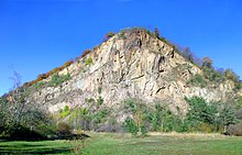
The Spaargebirge is a small up to 191.1 m above sea level. NHN high ridge about three kilometers east of Meißen and about two kilometers west of Coswig above the Elbe valley in Saxony .
geography
location
The Spaargebirge is located in the Saxon district of Meißen in the Elbe Valley landscape protection area on the northern side of the Elbe between the Coswig district of Sörnewitz in the southeast and the Meißner districts of Oberspaar in the northwest and Zaschendorf in the northeast. It is considered to be the smallest mountain range in Saxony (around three kilometers long and barely 200 meters wide), even if it is not actually a mountain range.
The highest elevation of the Spaargebirge is 191.1 m above sea level in the Oberspaar area . NHN high Karlshöhe with the Juchhöh viewpoint to the south . The Boselweg runs over the ridge in an approximately north-south direction to the Deutsche Bosel lookout point ( 182 m ), which is about 80 meters above the Elbe Valley and offers a view of Dresden and, if the visibility is good, Saxon Switzerland . A hiking trail continues to the Boselspitze in the southeast .
To the northeast of the Deutsche Bosel, separated by a valley, is the lower and much less known Roman Bosel ( 167.5 m above sea level ).
geology
The ridge was created by erosion of a tectonic disruption zone and was separated from the rest of the Meißner granite area like an island by a left tributary of the Ur-Elbe, which flowed north of the Spaargebirge through the Nassau . During the floods of spring 1845 , the Spaar Mountains were enclosed by the Elbe.
Development
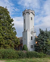
The 17 m high Bosel Tower was built near the Deutsche Bosel in 1898 ( ⊙ ), a listed observation tower that has been open to the public again since 2012 after extensive renovation.
A little further southeast is the Boselgarten , a botanical garden of the Technical University of Dresden . It was laid out in 1910 on the recommendation of the Dresden botanist Oscar Drude after the Saxon Heritage Protection Association bought the site to protect the rare plants growing here from the threat of rock mining.
A quarry used to be operated on the steeply sloping, rocky eastern tip. The formerly natural vegetation (subatlantic sand plants and south-east European dry grass plants) had to give way to today's fine fruit and wine cultivation. Due to the exceptionally favorable climatic conditions in the Elbe Valley, farms, knighthoods and wineries have been settling here since time immemorial (documented from 1352). The Saxon Wine Route and the Elbe Cycle Path run below the Spaar Mountains .
FFH protected area
Parts of the Spaargebirge are located in the fauna-flora-habitat area Bosel and Elbe slopes north of Meissen (FFH no. 4746-303; 1.57 km²).
Others
During the GDR era, the VEB lignite combine Lauchhammer ran a holiday camp for the children of its employees on the Boselspitze .
Individual evidence
- ↑ a b c d e Map services of the Federal Agency for Nature Conservation ( information )
- ↑ The Bosel Tower on the website of the Boselspitze guest house
- ↑ Facebook entry
literature
- Lössnitz and Moritzburg pond landscape (= values of our homeland . Volume 22). 1st edition. Akademie Verlag, Berlin 1973.
Coordinates: 51 ° 9 ′ N , 13 ° 30 ′ E


