
Spandau suburb

I Alt-Berlin II Alt-Kölln (Spreeinsel) III Friedrichswerder IV Dorotheenstadt V Friedrichstadt XI Luisenstadt XII Neu-Kölln XIII Stralauer Vorstadt XIV Royal Town XV Spandauer Vorstadt XVI Rosenthaler Vorstadt XVII Oranienburger Vorstadt XVIII Friedrich-Wilhelm-Stadt Sources: Contents: Berlin address book, map base: District Office Mitte von Berlin


The Spandauer Vorstadt (formerly also called Spandauer Viertel ) is a historic district in what is now Berlin 's Mitte district in the district of the same name .
geography
The Spandauer Vorstadt is bordered in the south by the Spree and the viaduct of the Stadtbahn , in the east by Karl-Liebknecht-Strasse and the adjacent Königsstadt , in the north by Torstrasse and the adjacent Rosenthaler and Oranienburger Vorstadt and in the west by Friedrichstrasse and the Friedrich Wilhelm City .
The Spandau suburb is connected to Dorotheenstadt via the Weidendammer Bridge , the Ebert Bridge and the Monbijou Bridge .
history
Explanation of the name
The suburb that developed in front of the Spandauer Tor soon also bore the name Spandauer Vorstadt or Spandauer Viertel . For the quarters that emerged beyond today's Torstrasse, the term Äußere Spandauer Vorstadt was used at times . In the end these quarters belonged to the Oranienburger and Rosenthaler Vorstadt.
The part of the Spandauer Vorstadt east of Rosenthaler Strasse is also known as the Scheunenviertel ; a name that is often erroneously extended to streets to the west of it because of the shtetl that was located there around 1900 , above all Oranienburger Strasse with the synagogue .
17th century to 19th century
The Spandauer Vorstadt developed north of the Spandauer Tor of the Berlin city wall . It has its origins in the Middle Ages and was initially a loose settlement in which Berliners operated gardening and agriculture for self-sufficiency. There was a similar use of the land in front of all city gates. With the construction of the fortress in the middle of the 17th century, the Spandauer Tor was moved slightly to the east in the area around today's Hackescher Markt , but the name was retained.
On the occasion of her marriage in 1668, Electress Dorothea received property in the area of the Spandauer Vorstadt and the Tiergartenvorwerk, which later became Dorotheenstadt , as a gift. She converted both sites into building land in order to obtain funds independently of the electoral court. In 1685, following the example of Dorotheenstadt, she had some streets built here, parceled out land and sold these to Berlin citizens and - on the basis of the Edict of Potsdam issued in the same year - to Huguenots .
The Weidendammer Bridge was also built in 1685. It led the then cross street of Dorotheenstadt over the Spree and thus connected the two lands of the Electress. As a continuation of this street to the north, the Dammstraße was laid out as a well-passable and representative avenue up to the country road to Oranienburg . The Dorotheenstadt was therefore much easier to reach from the north, just like the western Spandau suburb without a detour via the castle district . When the Friedrichstadt was laid out, the entire street was named Friedrichstrasse around 1705 .
Around 1700, on the Spandauer Heerweg , an old country road in front of the Monbijou Castle , which was later built , the Oranienburger Straße was expanded as a representative avenue. A plague house was built in the extreme northwest corner of the Spandau suburb in 1710 , from which the Charité emerged . In 1710 there were already around 500 residential buildings in the Spandau suburb. In 1712 it received its own parish church, the Sophienkirche in Große Hamburger Straße, which was donated by Queen Sophie Luise, Friedrich I's third wife .
In 1750, on the instructions of King Friedrich II , the Berlin customs wall was extended in the north to the line Prenzlauer Tor - Schönhauser Tor - Rosenthaler Tor - Hamburger Tor - Oranienburger Tor - (1836 New Gate) - Unterbaum (Spree). This course can still be clearly seen between Linienstraße (inside) and Torstraße (outside). Today's Hannoversche Strasse formed the further course. The facility was managed by the commander of Berlin, Hans Christoph v. Hacke (hence: Hackescher Markt ). The area between the Oranienburger Tor and Rosenthaler Tor was later named Oranienburger Vorstadt and Rosenthaler Vorstadt . In 1751 the fortress was leveled in this area except for a sewer ditch; the street name Am Zwirngraben still reminds of it today. A new Jewish quarter was also laid out in the eastern Spandau suburb (known today as the 'Scheunenviertel').
Since 1822, the Friedrich-Wilhelm-Stadt was built in the area west of Friedrichstraße, which was previously mainly used for horticulture . In 1828 it was separated from the Spandau suburb and since then has formed its own district. In the years before the First World War , a large part of the old Scheunenviertel was demolished and modernized as part of a renovation .
Since the 20th century
When Greater Berlin was formed in 1920, the Spandau suburb became part of the newly formed Mitte district. The Second World War caused comparatively little damage in the Spandau suburb. Some important historical buildings such as Monbijou Castle were destroyed and later demolished. The maintenance of the historical old building was neglected for decades, which led to vacancy and decay. Sophienstrasse was not reconstructed until the 1980s; At the same time, renovation began in places through demolition and new construction.
The Spandauer Vorstadt area is now a listed building ensemble and is considered the largest and best preserved historical district of Berlin. Since the German reunification in 1990, a large part of the building has been renovated and the Spandau suburb has developed into an attractive residential, business and trendy district with a clear tendency towards gentrification .
population
In 1890 the Spandauer Vorstadt (in the 18th and 19th centuries mainly called Spandau Quarter ) reached its highest population with 78,953.
politics
The Left Party has its headquarters on Rosa-Luxemburg-Platz at 28 Kleine Alexanderstraße . The Karl-Liebknecht-Haus was the headquarters of the Communist Party of Germany from 1926 to 1933 .
Culture and sights
Museums and galleries
In the Spandauer Vorstadt there are a number of museums that deal with the Jewish history of the quarter. The New Synagogue - Centrum Judaicum , opened in 1995, is located at Oranienburger Straße 28–30 , a center dedicated to the care and preservation of Jewish culture. In addition, the archive and library should serve research. The Anne Frank Center and the Otto Weidt workshop for the blind are located near Hackescher Markt at Rosenthaler Straße 39 .
Auguststrasse is known beyond the borders of Berlin for its gallery scene. Probably the most famous gallery, Kunst-Werke Berlin , is located at Auguststrasse 64.
Theater and variety
The Volksbühne, built between 1913 and 1914 according to plans by Oskar Kaufmann, is located on Rosa-Luxemburg-Platz, the former Bülowplatz .
The Friedrichstadtpalast has the largest theater stage in the world and a long tradition. Its story began at Am Zirkus 1, next to today's Berliner Ensemble . In 1984 the Friedrichstadtpalast moved to the newly built revue theater at Friedrichstrasse 107.
In the Hackesche Höfe, Rosenthaler Straße 40/41, there is the Chameleon variety theater , founded in 1991 , which shows changing programs.
Another performance location for theater and dance are the Sophiensæle in the craftsmen's association built in 1904/1905 .
Others
The ruins of the former Passage department store on Oranienburger Strasse had been occupied by artists in 1992 and made a name for itself as the Kunsthaus Tacheles . In 2012 the artists had to leave the house despite numerous protests. After the renovation and inclusion in the urban development project between Friedrichstrasse, Johannisstrasse and Oranienburger Strasse, the Tacheles is to be used again for cultural purposes.
Clärchens Ballhaus is located on Auguststrasse , an institution that has been dancing non-stop for over 100 years.
Special buildings
Buildings no longer in existence
Between 1703 and 1706, King Friedrich I had the court architect Eosander von Göthe built a small pleasure palace in the late Baroque style on the northern bank of the Spree beyond the Spandauer Tor. The Monbijou Castle last housed the Hohenzollern Museum. The two-storey gatehouses on Monbijouplatz shaped the cityscape. The castle and gatehouses were badly damaged in World War II and the ruins were torn down in 1959.
In 1859, the building of the Cathedral Candidate Foundation, built according to plans by Stüler , was inaugurated at Oranienburger Strasse 76a . Various parts of the building were grouped around an inner courtyard and a tower in the street front formed the distinctive highlight. The building complex, which had burned out during World War II, was demolished in 1972.
In 1884, on the grounds of Monbijou Castle , the St. George's Church (English Church), built according to plans by Julius Raschdorff , was inaugurated. The church, in the style of 19th century English churches, was destroyed in World War II.
In 1909, which was in the Friedrichstrasse 110-112 Friedrichstrasse Passage opened, connecting the Friedrichstrasse Oranienburgerstrasse. The portal buildings on both street fronts and the mighty domed hall inside the block were striking. In 1983 the building, which was last called the "House of Technology" and was badly damaged in World War II, was blown up. Only the front building on Oranienburger Strasse remained standing and became known as the Kunsthaus Tacheles .
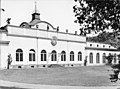
Monbijou Castle, Spreefront

English church
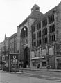
Friedrichstrasse Passage, Friedrichstrasse 110–112, shortly before the demolition


._Fortepan_50883.jpg)
Listed buildings

1. Hof der Hackesche Höfe

.jpg)


.jpg)
Modern buildings

In the years 1999–2000, an ensemble of twelve individual houses was built on the east side of Hackescher Markt on the corner of Dircksenstrasse, which by means of the plot division and design refer to the architecture of the area. Shops are located on the ground floors and the upper floors are mainly used for living. The architecture firm Bellmann & Böhm developed the master plan. Three other architectural offices were involved in the work through.
literature
- Spandauer Vorstadt in Berlin-Mitte. An art and monument guide . Michael Imhof Verlag, Petersberg 2006 (3rd edition), ISBN 3-937251-01-4 .
- Right through the middle. The Spandau suburb . Haude and Spener, Berlin 1998, ISBN 3-77590425-5 .
- Laurenz Demps : The Oranienburger Strasse . ISBN 3-932529-20-0 .
- Christian Krajewski: Urban transformation processes in city quarters close to the center - gentrification and internal differentiation using the example of the Spandauer Vorstadt and the Rosenthaler Vorstadt in Berlin . IfG. Münster 2006. ISBN 3-9809592-2-8 .
- The Spandau suburb - utopias and realities between Scheunenviertel and Friedrichstraße . Argon Verlag, Berlin 1995. ISBN 3-87024-327-9 .
- Herbert Schwenk: Lexicon of Berlin Urban Development. Haude and Spener, Berlin 2002, ISBN 3-7759-0472-7 .
Web links
- Literature about the Spandauer Vorstadt in the catalog of the German National Library
- Entry in the Berlin State Monument List with further information
- Christian Krajewski: Spandauer and Rosenthaler Vorstadt ( Memento from June 12, 2007 in the Internet Archive ) (PDF). Urban transformation processes between “trendy” and “living quarters”. Münster 2004. On page 220 there is a location map to classify the two suburbs.
- Klaus Bädicker: Photographs of the Spandau suburb from the 1980s and 1990s
- Torsten Elger: Panoramas of important places in the Spandau suburb
Individual evidence
- ^ Friedrich Leyden: Greater Berlin. Geography of the cosmopolitan city . Hirt, Breslau 1933 (therein: Development of the population in the historic districts of Old Berlin , p. 206)
Coordinates: 52 ° 31 '31 " N , 13 ° 23' 55" E