
St. Moritz lake
| St. Moritz lake | |||||||||
|---|---|---|---|---|---|---|---|---|---|
 |
|||||||||
|
|||||||||
|
|||||||||
| Coordinates | 784 779 / 152071 | ||||||||
| Data on the structure | |||||||||
| Data on the reservoir | |||||||||
| Water surface | 78 ha | ||||||||
| Reservoir length | 1.6 km | ||||||||
| Reservoir width | 600 m | ||||||||
| Maximum depth | 44 m (mean depth 26 m) | ||||||||
| Total storage space : | 20,000,000 m³ | ||||||||
| Catchment area | 171 | ||||||||

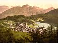
Lake St. Moritz ( Rhaeto-Romanic ) in the Upper Engadine is the northeasternmost and smallest of the four lakes in the Engadine Lake District.
geography
Lake St. Moritz, like Lake Sils , Lake Silvaplana and Lej da Champfèr, is traversed by the Inn . It lies at 1768 m above sea level. M. The center of St. Moritz is situated high above the North Shore, at its west end are the healing springs of St. Moritz-Bad.
The lake lies between the Piz Rosatsch ( 3123 m above sea level ) in the south and the Piz Nair ( 3056 m above sea level ) in the north. To the north of the lake, a bar blocks the Inn Valley, through which the river has dug an exit in the form of the narrow Charnadüra Gorge .
Energy use
As soon as it emerged from the lake, the Inn used to fall over a waterfall that no longer exists today. Since 1932, two 14 meter wide roof weirs have been regulating the outflow from the lake and keeping the lake level constant. The water is dammed 120 centimeters high. A fish ladder enables fish to overcome the weir.
From 1892, the Charnadüra power station used the water from the lake and processed the water in a machine house 21.5 meters deeper in the Charnadüra . It was replaced in 1932 by the Islas power station , which uses the entire gradient between Lake St. Moritz and the valley floor near Celerina.
tourism

The lake is mainly known because in winter, when it is frozen over, numerous events take place on the ice. These include the White Turf horse races , which take place every February. Well over 200 tons of material are placed on the ice, which must be at least 30 centimeters thick. The Engadine Ski Marathon route also runs across the lake.
With the rise of tourism, St. Moritz has expanded more and more towards the lake. In 1904 the Rhaetian Railway station , the terminus of the Albula line , opened at the outflow on the north bank. Most of the southern bank areas and the eastern end of the lake, which extends to the Stazerwald , are still undeveloped .
photos
St. Moritz Dorf around 1900

St. Moritz Bad around 1900

St. Moritz 1962

Eastern part of the lake


Web links
- Lake St. Moritz water level (Federal Office for the Environment)
- Charles Knapp, Maurice Borel, Victor Attinger, Heinrich Brunner, Société neuchâteloise de géographie (editors): Geographical Lexicon of Switzerland . Volume 4: Plessur - Switzerland . Verlag Gebrüder Attinger, Neuenburg 1906, p. 466 f., Keyword Sankt Moritzersee ( scan of the lexicon page ).
Individual evidence
- ↑ Hydrological basics and data - station data St.Moritzersee - St.Moritz. In: Federal Office for the Environment. Retrieved March 6, 2013 .
- ^ Charles Knapp, Maurice Borel, Victor Attinger, Heinrich Brunner, Société neuchâteloise de geographie (editor): Geographical Lexicon of Switzerland . Volume 4: Plessur - Switzerland . Verlag Gebrüder Attinger, Neuenburg 1906, p. 466 f., Keyword Sankt Moritzersee ( scan of the lexicon page ).
- ^ A b Franco Milani: The white coal of St. Moritz and Celerina: 100 years since the integration of the power station into the municipality of St. Moritz, 135 years of electric light in St. Moritz . Ed .: St. Moritz Energie. 1st edition. Montabella, St. Moritz 2014, ISBN 978-3-907067-42-0 , p. 48 ff., 60 f . ( stmoritz-energie.ch [PDF; accessed on May 28, 2020]).
- ^ Brigit Weibel: Frozen Lake St. Moritz. In: Einstein. Swiss radio and television , February 14, 2013, accessed on May 28, 2020 .